File:NYCS map 7.svg
Salta a la navegació
Salta a la cerca

Mida d'aquesta previsualització PNG del fitxer SVG: 490 × 599 píxels. Altres resolucions: 196 × 240 píxels | 393 × 480 píxels | 628 × 768 píxels | 838 × 1.024 píxels | 1.676 × 2.048 píxels | 648 × 792 píxels.
Fitxer original (fitxer SVG, nominalment 648 × 792 píxels, mida del fitxer: 379 Ko)
Llegendes
Llegendes
Afegeix una explicació d'una línia del que representa aquest fitxer
Resum[modifica]
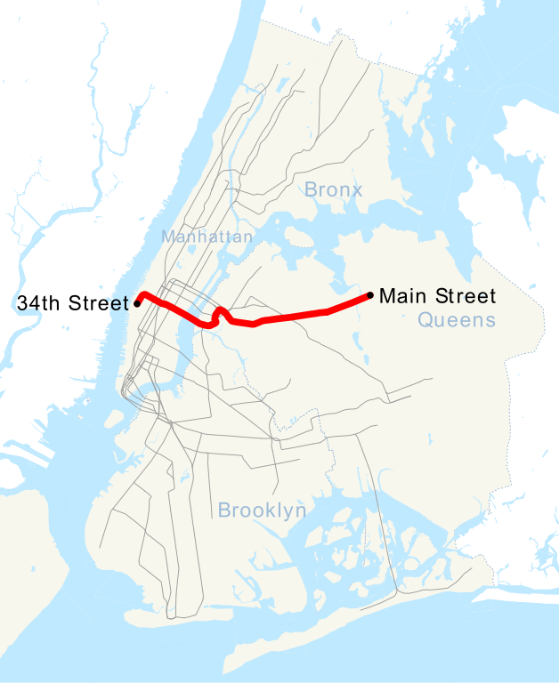
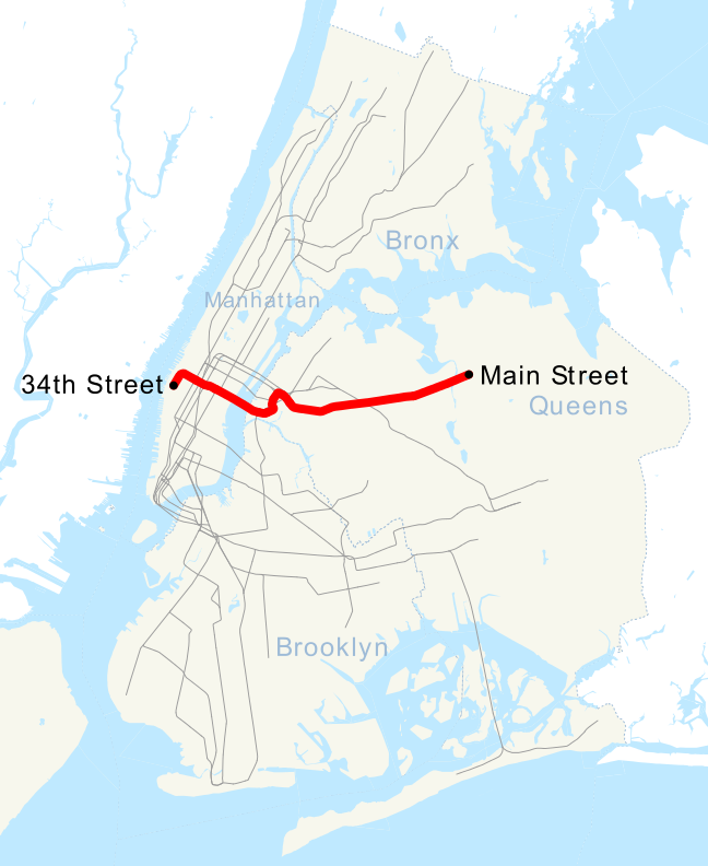
| Descripció | This is a map showing the New York City Subway's 7 service. It was created with TIGER/Line GIS data (water and boundaries) and my own data (subway lines and stations, traced on TIGER/Line road data). If you would like a copy of the subway data, email me. |
| Data | 1r de maig de 2007 (original upload date) |
| Font | No machine-readable source provided. Own work assumed (based on copyright claims). |
| Autor | No machine-readable author provided. NE2 assumed (based on copyright claims). |
Llicència[modifica]
| Jo, el titular del copyright d'aquesta obra, l'allibero al domini públic. Això s'aplica a tot el món. En alguns països això pot no ser legalment possible, en tal cas: Jo faig concessió a tothom del dret d'usar aquesta obra per a qualsevol propòsit, sense cap condició llevat d'aquelles requerides per la llei. |
Historial del fitxer
Cliqueu una data/hora per veure el fitxer tal com era aleshores.
| Data/hora | Miniatura | Dimensions | Usuari/a | Comentari | |
|---|---|---|---|---|---|
| actual | 06:49, 12 set 2015 | | 648 × 792 (379 Ko) | Jc86035 (discussió | contribucions) | moved text marker for 34th St |
| 06:38, 12 set 2015 |  | 648 × 792 (377 Ko) | Jc86035 (discussió | contribucions) | fixed text (sans-serif to Arial) to match and changed it to path, fixed/simplified path of 7 extension, cleaned up with SVGCleaner | |
| 19:27, 11 set 2015 |  | 648 × 792 (380 Ko) | DMacks (discussió | contribucions) | remove "Times Square" label (previously-removed box had covered it) | |
| 15:29, 11 set 2015 |  | 648 × 792 (390 Ko) | DMacks (discussió | contribucions) | remove white rectangle just above "Times Square" | |
| 15:45, 2 set 2015 |  | 648 × 792 (390 Ko) | FlushingLocal (discussió | contribucions) | Reverted to version as of 15:43, 2 September 2015 | |
| 15:45, 2 set 2015 |  | 648 × 792 (390 Ko) | FlushingLocal (discussió | contribucions) | Updated again to an issue with the original file. | |
| 15:43, 2 set 2015 |  | 648 × 792 (390 Ko) | FlushingLocal (discussió | contribucions) | Updated 7 Train Map to 34 St - Hudson Yards as the new terminal and removed Times Square | |
| 10:48, 29 oct 2011 |  | 648 × 792 (464 Ko) | Robot8A (discussió | contribucions) | text to path because you can't see it properly in article | |
| 00:04, 1 maig 2007 |  | 648 × 792 (389 Ko) | NE2 (discussió | contribucions) | == Summary == This is a map showing the New York City Subway's 7 service. It was created with TIGER/Line GIS data (water and boundaries) and my own data (subway lines and stations, traced on TIGER/Line road data). If you would like a copy of the subway da |
No podeu sobreescriure aquest fitxer.
Ús del fitxer
Les 7 pàgines següents utilitzen aquest fitxer:
- User:Chumwa/OgreBot/Public transport information/2015 September 1-10
- User:Chumwa/OgreBot/Public transport information/2015 September 11-20
- User:Chumwa/OgreBot/Transport Maps/2015 September 1-10
- User:Chumwa/OgreBot/Transport Maps/2015 September 11-20
- Category:7 (New York City Subway service)
- Category:IRT Flushing Line
- Category:Views from the IRT Flushing Line
Ús global del fitxer
Utilització d'aquest fitxer en altres wikis:
- Utilització a ca.wikipedia.org
- Utilització a de.wikipedia.org
- Utilització a en.wikipedia.org
- Utilització a es.wikipedia.org
- Utilització a et.wikipedia.org
- Utilització a fi.wikipedia.org
- Utilització a fr.wikipedia.org
- Utilització a he.wikipedia.org
- Utilització a ja.wikipedia.org
- Utilització a ko.wikipedia.org
- Utilització a lmo.wikipedia.org
- Utilització a nl.wikipedia.org
- Utilització a no.wikipedia.org
- Utilització a pl.wikipedia.org
- Utilització a pt.wikipedia.org
- Utilització a ru.wikipedia.org
- Utilització a www.wikidata.org
- Utilització a zh.wikipedia.org