File:NY Metropolitan Area.png
Jump to navigation
Jump to search

Size of this preview: 800 × 591 pixels. Other resolutions: 320 × 237 pixels | 640 × 473 pixels | 1,024 × 757 pixels | 1,280 × 946 pixels | 2,560 × 1,893 pixels | 4,200 × 3,105 pixels.
Original file (4,200 × 3,105 pixels, file size: 2.72 MB, MIME type: image/png)
Captions
Captions
Add a one-line explanation of what this file represents
Summary
[edit]
| Description |
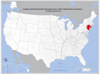
English: Map of Counties with New York Metropolitan Area highlighted. |
| Date | |
| Source | https://www2.census.gov/geo/maps/general_ref/us_base/stco2010/USstcou2010_wallmap.pdf |
| Author | US Census Bureau, Edited by user Andololol to highlight New York Metropolitan Area. |
Licensing
[edit]
This image or file is a work of a United States Census Bureau employee, taken or made as part of that person's official duties. As a work of the U.S. federal government, the image is in the public domain.
|
 |
File history
Click on a date/time to view the file as it appeared at that time.
| Date/Time | Thumbnail | Dimensions | User | Comment | |
|---|---|---|---|---|---|
| current | 19:20, 8 December 2020 | | 4,200 × 3,105 (2.72 MB) | Brianski (talk | contribs) | file is painfully slow to download; remove alpha channel, light optimization |
| 03:18, 25 March 2016 |  | 4,200 × 3,105 (4.85 MB) | Andololol (talk | contribs) | User created page with UploadWizard |
You cannot overwrite this file.
File usage on Commons
The following page uses this file:
File usage on other wikis
The following other wikis use this file:
- Usage on ar.wikipedia.org
- Usage on ast.wikipedia.org
- Usage on bg.wikipedia.org
- Usage on bn.wikipedia.org
- Usage on ca.wikipedia.org
- Usage on en.wikipedia.org
- Usage on eo.wikipedia.org
- Usage on et.wikipedia.org
- Usage on fa.wikipedia.org
- Usage on fi.wikipedia.org
- Usage on fr.wikipedia.org
- Usage on he.wikipedia.org
- Usage on ko.wikipedia.org
- Usage on pt.wikipedia.org
- Usage on sh.wikipedia.org
- Usage on tl.wikipedia.org
- Usage on uk.wikipedia.org
- Usage on www.wikidata.org