File:NZL orthographic NaturalEarth labelled en.svg
跳转到导航
跳转到搜索

此SVG文件的PNG预览的大小:553 × 553像素。 其他分辨率:240 × 240像素 | 480 × 480像素 | 768 × 768像素 | 1,024 × 1,024像素 | 2,048 × 2,048像素。
原始文件 (SVG文件,尺寸为553 × 553像素,文件大小:734 KB)
说明
说明
添加一行文字以描述该文件所表现的内容
摘要[编辑]
| 描述 |
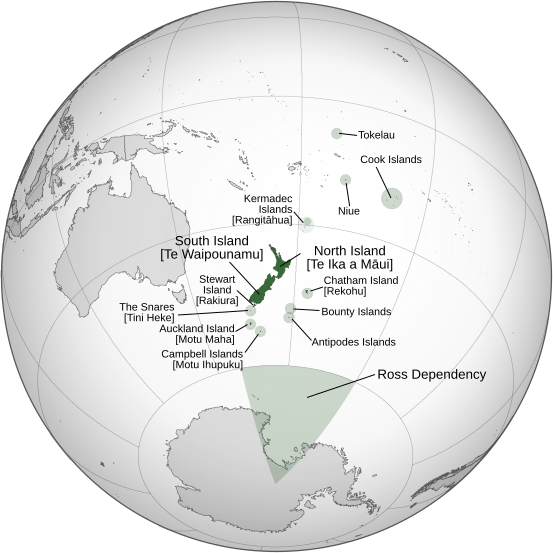
English: A map of the hemisphere centred on Wellington, New Zealand, using an orthographic projection, created using gringer's Perl script with Natural Earth Data (1:50000 resolution, simplified to 0.25px) and LINZ Data. New Zealand is highlighted in green. This map has been additionally annotated with Māori and English names for islands within the Realm of New Zealand. |
| 日期 | |
| 来源 | 自己的作品 |
| 作者 | Gringer |
| 其他版本 |
[]
|


许可协议[编辑]
我,本作品著作权人,特此采用以下许可协议发表本作品:
| 本作品采用知识共享CC0 1.0 通用公有领域贡献许可协议授权。 | |
| 采用本宣告发表本作品的人,已在法律允许的范围内,通过在全世界放弃其对本作品拥有的著作权法规定的所有权利(包括所有相关权利),将本作品贡献至公有领域。您可以复制、修改、传播和表演本作品,将其用于商业目的,无需要求授权。
|
文件历史
点击某个日期/时间查看对应时刻的文件。
| 日期/时间 | 缩略图 | 大小 | 用户 | 备注 | |
|---|---|---|---|---|---|
| 当前 | 2018年3月10日 (六) 13:33 | | 553 × 553(734 KB) | Gringer(留言 | 贡献) | Shifted sea base down to match circle |
| 2018年3月10日 (六) 13:15 |  | 553 × 553(734 KB) | Gringer(留言 | 贡献) | User created page with UploadWizard |
您不可以覆盖此文件。
文件用途
以下5个页面使用本文件:
全域文件用途
以下其他wiki使用此文件:
- ar.wikipedia.org上的用途
- en.wikipedia.org上的用途
- es.wikipedia.org上的用途
- fa.wikipedia.org上的用途
- fr.wikipedia.org上的用途
- he.wikipedia.org上的用途
- hy.wikipedia.org上的用途
- ko.wikipedia.org上的用途
- pl.wikipedia.org上的用途
- pt.wikipedia.org上的用途
- th.wikipedia.org上的用途
- tr.wikipedia.org上的用途
- uk.wikipedia.org上的用途
- vi.wikipedia.org上的用途
- www.wikidata.org上的用途
- zh.wikipedia.org上的用途