File:N 206-08008).jpg
Jump to navigation
Jump to search

Size of this preview: 800 × 449 pixels. Other resolutions: 320 × 180 pixels | 640 × 359 pixels | 1,024 × 575 pixels | 1,280 × 719 pixels | 2,560 × 1,438 pixels | 4,015 × 2,255 pixels.
Original file (4,015 × 2,255 pixels, file size: 3.04 MB, MIME type: image/jpeg)
Captions
Captions
Add a one-line explanation of what this file represents
Summary
[edit].jpg&action=edit§ion=1)
| Description |
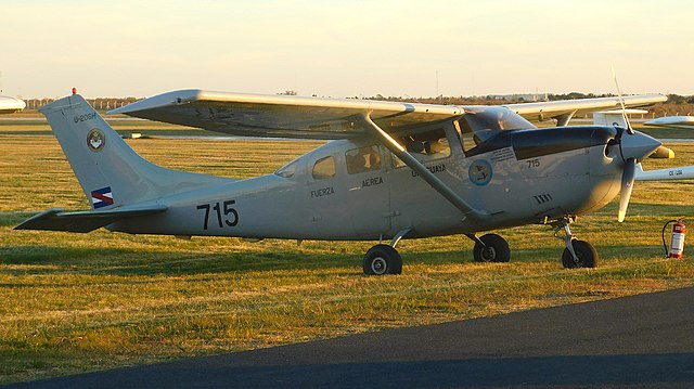
Español: Cessna U-206H Stationair matrícula FAU 715 (s/n 206-08008) perteneciente al Escuadrón Aéreo N.° 7 (Observación y Enlace) de la Fuerza Aérea Uruguaya. Esta aeronave de origen estadounidense fue adquirida completamente nueva, mediante una licitación pública junto a otras nueve de su mismo tipo, dentro del contexto de un plan de reequipamiento de aeronaves de enlace por parte de la Fuerza Aérea de la República Oriental del Uruguay. Fue trasladada en vuelo desde el día 8 de diciembre del año 1998, partiendo desde Independence, Kansas, Estados Unidos de América, al mando de tripulaciones uruguayas, arribando a Uruguay el día 22 de diciembre del año 1998, tras diversas escalas. Fue asignada a la entonces Brigada de Seguridad Terrestre mediante la Orden del Comando General de la Fuerza Aérea N.° 4.425, pero con la creación del Escuadrón Aéreo N.° 7 (Observación y Enlace) el día 16 de abril del año 1999, mediante el Artículo 2 del Decreto del Poder Ejecutivo N.° 113/99, fue transferida a esa unidad, en donde se ha encontrado prestando servicios al año 2023. La aeronave luce la insignia de la Unidad sobre su estabilizador vertical. |
| Date | |
| Source | https://www.flickr.com/photos/sebastianlaguna/52544641972/ |
| Author | Sebastián Laguna |
| Camera location | | View this and other nearby images on: OpenStreetMap |
|---|
.jpg¶ms=-34.785479_N_-056.263228_E_globe:Earth_type:camera__&language=en)
Licensing
[edit].jpg&action=edit§ion=2)
This file is licensed under the Creative Commons Attribution 2.0 Generic license.
- You are free:
- to share – to copy, distribute and transmit the work
- to remix – to adapt the work
- Under the following conditions:
- attribution – You must give appropriate credit, provide a link to the license, and indicate if changes were made. You may do so in any reasonable manner, but not in any way that suggests the licensor endorses you or your use.
| This image was originally posted to Flickr by Sebastián Laguna. at https://flickr.com/photos/192917376@N05/52544641972. It was reviewed on 5 December 2022 by FlickreviewR 2 and was confirmed to be licensed under the terms of the cc-by-2.0. |
File history
Click on a date/time to view the file as it appeared at that time.
| Date/Time | Thumbnail | Dimensions | User | Comment | |
|---|---|---|---|---|---|
| current | 20:45, 5 December 2022 | | 4,015 × 2,255 (3.04 MB) | Sebiiyaa (talk | contribs) | Uploaded a work by Sebastián Laguna from https://www.flickr.com/photos/sebastianlaguna/52544641972/ with UploadWizard |
You cannot overwrite this file.
File usage on Commons
There are no pages that use this file.
File usage on other wikis
The following other wikis use this file:
- Usage on en.wikipedia.org
- Usage on es.wikipedia.org
.jpg&oldid=894536860)