File:Namibia map.png
Jump to navigation
Jump to search
No higher resolution available.
Namibia_map.png (326 × 349 pixels, file size: 19 KB, MIME type: image/png)
Captions
Captions
Add a one-line explanation of what this file represents
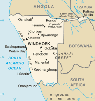
CIA map of Namibia
- See also the 2004 version.
.png)
This image is in the public domain because it contains materials that originally came from the United States Central Intelligence Agency's World Factbook.
|
 |
derivative works[edit]
Derivative works of this file: Namibia map-sv.png
File history
Click on a date/time to view the file as it appeared at that time.
| Date/Time | Thumbnail | Dimensions | User | Comment | |
|---|---|---|---|---|---|
| current | 10:17, 17 January 2022 | | 326 × 349 (19 KB) | Lojwe (talk | contribs) | Cropped 1 % horizontally, 1 % vertically using CropTool with precise mode. |
| 07:59, 21 July 2007 |  | 328 × 353 (20 KB) | Hoshie (talk | contribs) | Updated map of Namibia from the CIA World Factbook, 14 June 07 rev. Src: https://www.cia.gov/library/publications/the-world-factbook/maps/wa-map.gif | |
| 20:51, 4 March 2005 |  | 330 × 355 (9 KB) | Alfio (talk | contribs) | CIA map of Namibia |
You cannot overwrite this file.
File usage on Commons
The following 4 pages use this file:
File usage on other wikis
The following other wikis use this file:
- Usage on af.wikipedia.org
- Usage on ar.wikipedia.org
- Usage on bg.wikipedia.org
- Usage on ca.wikipedia.org
- Usage on da.wikipedia.org
- Usage on de.wikipedia.org
- Usage on dsb.wikipedia.org
- Usage on en.wikipedia.org
- Usage on fi.wikipedia.org
- Usage on fr.wikipedia.org
- Usage on hif.wikipedia.org
- Usage on hr.wikipedia.org
- Usage on hu.wikipedia.org
- Usage on hu.wiktionary.org
- Usage on incubator.wikimedia.org
- Usage on it.wikipedia.org
- Usage on ja.wikipedia.org
- Usage on ka.wikipedia.org
- Usage on kg.wikipedia.org
- Usage on kn.wikipedia.org
View more global usage of this file.