File:National Highway 8 (India).png
跳至導覽
跳至搜尋

預覽大小:565 × 599 像素。 其他解析度:226 × 240 像素 | 453 × 480 像素 | 662 × 702 像素。
原始檔案 (662 × 702 像素,檔案大小:432 KB,MIME 類型:image/png)
說明
說明
添加單行說明來描述出檔案所代表的內容
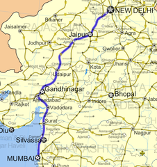
| 描述 | National Highway 8 in India |
| 日期 | (UTC) |
| 來源 | |
| 作者 |
|
| 這是一張修飾過的圖片,即本圖片是用軟體修改過後的版本。原版圖片來源:India roadway map.svg。
|
我,本作品的著作權持有者,決定用以下授權條款發佈本作品:
此檔案採用創用CC 姓名標示-相同方式分享 3.0 未在地化版本授權條款。
- 您可以自由:
- 分享 – 複製、發佈和傳播本作品
- 重新修改 – 創作演繹作品
- 惟需遵照下列條件:
- 姓名標示 – 您必須指名出正確的製作者,和提供授權條款的連結,以及表示是否有對內容上做出變更。您可以用任何合理的方式來行動,但不得以任何方式表明授權條款是對您許可或是由您所使用。
- 相同方式分享 – 如果您利用本素材進行再混合、轉換或創作,您必須基於如同原先的相同或兼容的條款,來分布您的貢獻成品。
原始上傳日誌
[編輯].png&action=edit§ion=1)
This image is a derivative work of the following images:
- File:India_roadway_map.svg licensed with Cc-by-sa-3.0
- 2007-04-02T06:14:09Z Gmaxwell 1639x1852 (931168 Bytes) Please do not include copyrighted fonts in your SVGs.
- 2007-04-02T06:13:22Z Gmaxwell 1639x1852 (931168 Bytes) Please do not include copyrighted fonts in your SVGs.
- 2007-01-09T07:33:51Z PlaneMad 1639x1852 (1025350 Bytes) uttaranchal>uttarkhand, minor color corrections and numbering correction
- 2006-11-13T17:04:31Z PlaneMad 1639x1852 (1042154 Bytes) designation for all highways
- 2006-11-09T10:59:17Z PlaneMad 1639x1852 (885509 Bytes) updated karnataka city spellings, added nh 110 112 113 114 116 117 119 121 123 153 154 155 224 225 226 227, corrections in north east states
- 2006-11-06T19:31:09Z PlaneMad 1639x1852 (864712 Bytes) nh designation markers on nhdp highways, rivers enabled, lightened state names, 3d locators for capitals and major cities, minor corrections north east areas
- 2006-10-15T18:01:16Z PlaneMad 1639x1852 (734840 Bytes) Included Nhdp phase IIIA, Changed stroke styles for highways, changed marker locators, added state names, included road legend, added more cities and towns, corrections
- 2006-08-01T18:38:00Z PlaneMad 1639x1852 (619927 Bytes) 100% highway coverage, more towns added, route corrections
- 2006-06-28T18:37:38Z PlaneMad 1639x1852 (1103121 Bytes) added cities and towns throughout india, all rivers added
- 2006-06-27T19:33:15Z PlaneMad 1639x1852 (953120 Bytes) first upload, includes 59000+ km of national highways + NHDP phase I II
Uploaded with derivativeFX
檔案歷史
點選日期/時間以檢視該時間的檔案版本。
| 日期/時間 | 縮圖 | 尺寸 | 使用者 | 備註 | |
|---|---|---|---|---|---|
| 目前 | 2009年5月31日 (日) 03:26 | | 662 × 702(432 KB) | Abhijitsathe(留言 | 貢獻) | Higher resolution |
| 2009年4月3日 (五) 02:06 |  | 529 × 590(302 KB) | Abhijitsathe(留言 | 貢獻) | {{Information |Description=National Highway 8 in India |Source=*File:India_roadway_map.svg |Date=2009-04-03 03:05 (UTC) |Author=*File:India_roadway_map.svg: '''Cc-by-sa-3.0''' *derivative work: ~~~ |Permission=see below |other_versions= }} {{ |
無法覆蓋此檔案。
檔案用途
下列頁面有用到此檔案:
全域檔案使用狀況
以下其他 wiki 使用了這個檔案:
- bn.wikipedia.org 的使用狀況
- de.wikipedia.org 的使用狀況
- en.wikipedia.org 的使用狀況
- en.wikivoyage.org 的使用狀況
- he.wikivoyage.org 的使用狀況
- hi.wikivoyage.org 的使用狀況
- ml.wikipedia.org 的使用狀況
- mr.wikipedia.org 的使用狀況
- or.wikipedia.org 的使用狀況
- pnb.wikipedia.org 的使用狀況
- ta.wikipedia.org 的使用狀況
- ur.wikipedia.org 的使用狀況
- www.wikidata.org 的使用狀況
- zh.wikipedia.org 的使用狀況
.png&oldid=493705337)