File:Nationalratswahl Österreich 2019.svg
Jump to navigation
Jump to search

Size of this PNG preview of this SVG file: 800 × 429 pixels. Other resolutions: 320 × 171 pixels | 640 × 343 pixels | 1,024 × 549 pixels | 1,280 × 686 pixels | 2,560 × 1,371 pixels | 1,400 × 750 pixels.
Original file (SVG file, nominally 1,400 × 750 pixels, file size: 3.01 MB)
Captions
Captions
Add a one-line explanation of what this file represents
Summary
[edit]| Description |
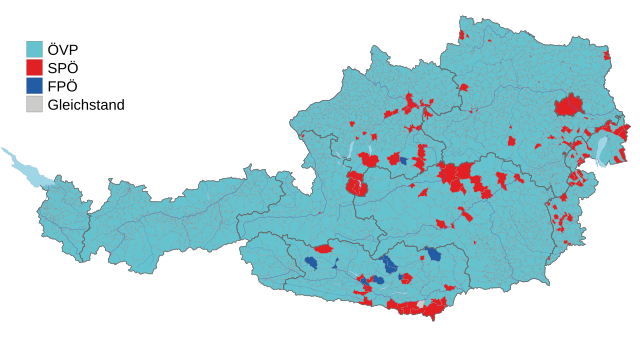
Deutsch: Stimmenstärkste Parteien bei der Nationalratswahl in Österreich 2019 nach Gemeinden.
English: Party majorities in the Austrian legislative election, 2019 according to municipalities. |
||
| Date | |||
| Source |
Gemeindekarten von Statistik Austria
|
||
| Author | Furfur | ||
| Permission (Reusing this file) |
I, the copyright holder of this work, hereby publish it under the following licenses:
This file is licensed under the Creative Commons Attribution-Share Alike 4.0 International license.
You may select the license of your choice. |
||
| SVG development | This vector image was created with Adobe Illustrator. |

File history
Click on a date/time to view the file as it appeared at that time.
| Date/Time | Thumbnail | Dimensions | User | Comment | |
|---|---|---|---|---|---|
| current | 14:56, 6 October 2019 | | 1,400 × 750 (3.01 MB) | Furfur (talk | contribs) | Korrektur Sankt Urban (Kärnten) und Detailänderungen |
| 17:27, 3 October 2019 |  | 1,400 × 750 (2.98 MB) | Chondrocladia (talk | contribs) | nicht (mehr) nötiger Legendeneintrag | |
| 16:07, 1 October 2019 |  | 1,400 × 750 (2.98 MB) | Chondrocladia (talk | contribs) | Detailkarte Wien entfernt mit folgender Begründnung: Anders als in Gemeindeergebnisse fließen in die Bezirksergebnisse auch die Wahlkarten ein, die z.B. im 2. Bezirk zu einem Wechsel der stärksten Partei geführt haben. Die Wien-Detailkarte ist wohl bei einer Darstellung der pol. Bezirke besser aufgehoben, weil dann lückenlos die Gesamtergebnisse mit Wahlkarten verwendet werden können. | |
| 21:11, 29 September 2019 |  | 1,400 × 750 (3.02 MB) | Furfur (talk | contribs) | Grenzen der Bundesländer dicker, ... dieses ÖVP-Türkis gefällt mir irgendwie nicht, eine alberne Modefarbe ... | |
| 21:05, 29 September 2019 |  | 1,400 × 750 (3.02 MB) | Furfur (talk | contribs) | == {{int:filedesc}} == {{Information |Description={{User:Medium69/Traduction}} {{de|1=Mehrheiten bei der Nationalratswahl in Österreich 2019 nach Parteien.}} {{en|1=Party majorities in the Austrian legislative election, 2019 according to municipalities.}} |Source=Gemeindekarten von Statistik Austria * data source: [https://www.derstandard.at/story/2000109126022/so-haben-die-gemeinden-bei-der-nationalratswa... |
You cannot overwrite this file.
File usage on Commons
The following 2 pages use this file:
File usage on other wikis
The following other wikis use this file:
- Usage on ar.wikipedia.org
- Usage on bs.wikipedia.org
- Usage on ca.wikipedia.org
- Usage on de.wikipedia.org
- Usage on el.wikipedia.org
- Usage on en.wikipedia.org
- Usage on fr.wikipedia.org
- Usage on it.wikipedia.org
- Usage on no.wikipedia.org
- Usage on zh.wikipedia.org