File:Naturschutzgebiet Bilstein im Höllental. (2).jpg
Jump to navigation
Jump to search

Size of this preview: 800 × 600 pixels. Other resolutions: 320 × 240 pixels | 640 × 480 pixels | 1,024 × 768 pixels | 1,280 × 960 pixels | 2,560 × 1,920 pixels | 5,184 × 3,888 pixels.
Original file (5,184 × 3,888 pixels, file size: 6.91 MB, MIME type: image/jpeg)
Captions
Captions
Add a one-line explanation of what this file represents
Summary
[edit].jpg&action=edit§ion=1)
| Description |
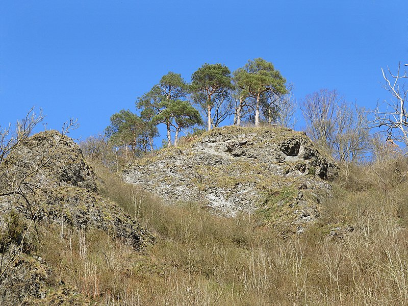
Deutsch: Die schroffen Felsen des Bilsteins liegen im östlichen Meißnervorland im Gemeindegebiet des Eschweger Stadtteils Albungen im Werra-Meißner-Kreis. Vom Tal der Berka steigt der Bilstein von 180 m auf 284,3 m über NN steil an. Das Berkatal zwischen Frankershausen und Albungen, das in diesem Teil "Höllental" genannt wird, ist hier eng und steilwandig. Beidseitig ragen steile Klippen aus hartem Diabasgestein auf.
Den ersten Schutzstatus erhielt der Bilstein schon vor über 100 Jahren, in 1914, wegen seiner geologischen und botanischen Besonderheiten. In 1960 folgte die Ausweisung zum Naturschutzgebiet mit einer Fläche von 3,19 Hektar und dem WDPA ID-Code 81402. Mit gleichen Gebietsgrenzen und Erhaltungszielen wurde der Bilstein dann in 2008 als Fauna-Flora-Habitat-Gebiet mit der Nr. 4725-303 Teil des europäischen Schutzgebietsnetzwerkes Natura 2000. Das Gebiet gehört zum Geo-Naturpark Frau-Holle-Land.
|
||
| Date | |||
| Source | Own work | ||
| Author | Heinz K. S. |
Licensing
[edit].jpg&action=edit§ion=2)
I, the copyright holder of this work, hereby publish it under the following license:
This file is licensed under the Creative Commons Attribution-Share Alike 4.0 International license.
- You are free:
- to share – to copy, distribute and transmit the work
- to remix – to adapt the work
- Under the following conditions:
- attribution – You must give appropriate credit, provide a link to the license, and indicate if changes were made. You may do so in any reasonable manner, but not in any way that suggests the licensor endorses you or your use.
- share alike – If you remix, transform, or build upon the material, you must distribute your contributions under the same or compatible license as the original.
This image was uploaded as part of Wiki Loves Earth 2018.
|
 |
File history
Click on a date/time to view the file as it appeared at that time.
| Date/Time | Thumbnail | Dimensions | User | Comment | |
|---|---|---|---|---|---|
| current | 20:42, 30 May 2018 | | 5,184 × 3,888 (6.91 MB) | Heinz K. S. (talk | contribs) | User created page with UploadWizard |
You cannot overwrite this file.
File usage on Commons
The following page uses this file:
File usage on other wikis
The following other wikis use this file:
- Usage on de.wikipedia.org
.jpg&oldid=594202034)