File:NaziGaue.png
Jump to navigation
Jump to search
Size of this preview: 698 × 600 pixels. Other resolutions: 279 × 240 pixels | 559 × 480 pixels | 894 × 768 pixels | 1,224 × 1,052 pixels.
Original file (1,224 × 1,052 pixels, file size: 431 KB, MIME type: image/png)
Captions
Captions
Add a one-line explanation of what this file represents
Summary[edit]
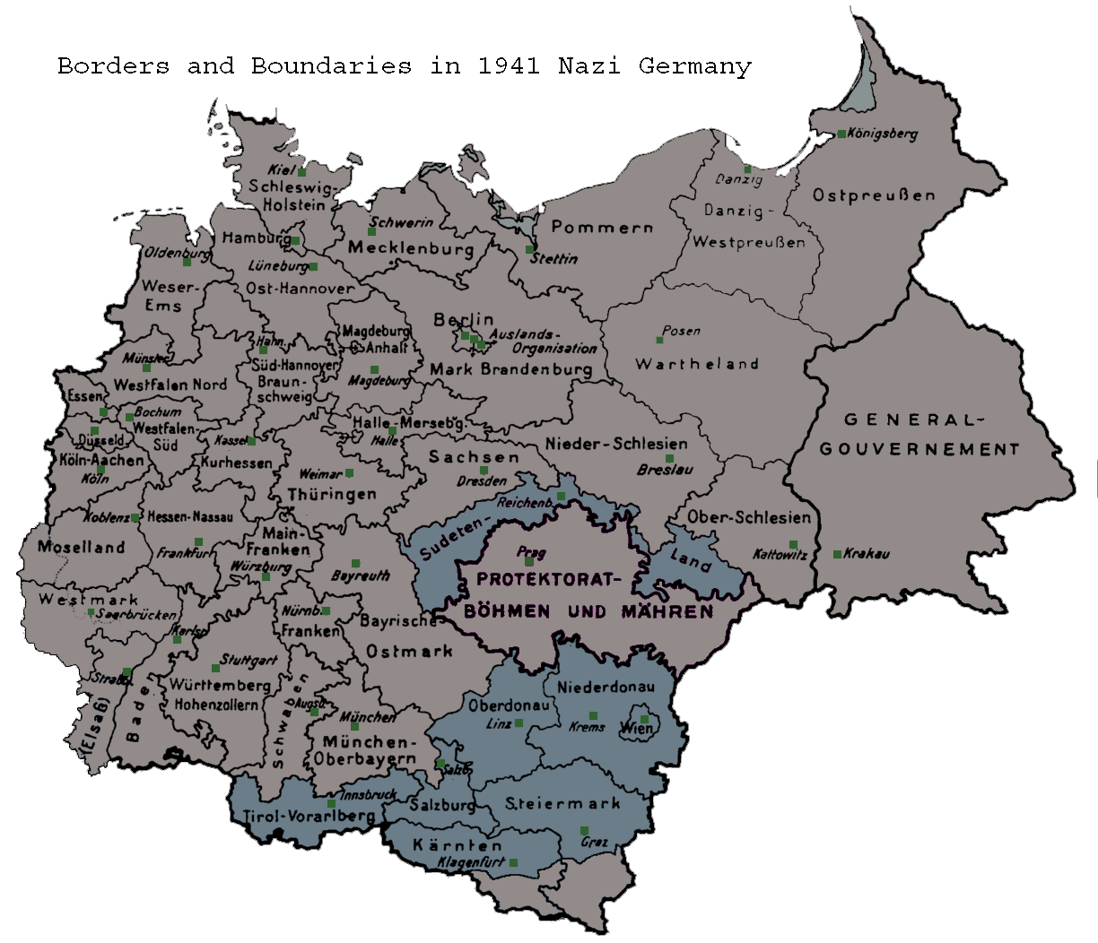
| Description | Map of the administrative districts in territories under the control of Nazi Germany in 1941. This map shows administration borders and has been retouched from the original Wiki Commons image. Specifically, German descriptions and titling have been eliminated. |
| Date | 26 May 2006 (original upload date) |
| Source | Transferred from en.wikipedia to Commons. |
| Author | Hohns3 at English Wikipedia |
Licensing[edit]
| This work has been released into the public domain by its author, Hohns3 at English Wikipedia. This applies worldwide. In some countries this may not be legally possible; if so: Hohns3 grants anyone the right to use this work for any purpose, without any conditions, unless such conditions are required by law. |
Original upload log[edit]
The original description page was here. All following user names refer to en.wikipedia.
- 2006-05-26 01:08 Hohns3 1224×1052×8 (441610 bytes) Map of the administrative districts in Nazi Germany in 1941. This make shows national and political borders and has been retouched from the original Wiki Commons image. Specifically, German descriptions and titling have been eliminated.
File history
Click on a date/time to view the file as it appeared at that time.
| Date/Time | Thumbnail | Dimensions | User | Comment | |
|---|---|---|---|---|---|
| current | 05:39, 21 June 2007 | | 1,224 × 1,052 (431 KB) | Moonian (talk | contribs) | {{Information |Description=Map of the administrative districts in territories under the control of Nazi Germany in 1941. This map shows administration borders and has been retouched from the original Wiki Commons image. Specifically, German descriptions |
You cannot overwrite this file.
File usage on Commons
The following page uses this file:
File usage on other wikis
The following other wikis use this file:
- Usage on an.wikipedia.org
- Usage on azb.wikipedia.org
- Usage on hr.wikipedia.org
- Usage on ka.wikipedia.org
- Usage on lt.wikipedia.org
- Usage on sh.wikipedia.org
- Usage on sl.wikipedia.org