File:Near east lrg.jpg

Fichièr d'origina (2 987 × 3 967 pixèl, talha del fichièr: 2,62 Mo, tipe MIME: image/jpeg)
Llegendes
Llegendes
| Descripcion |
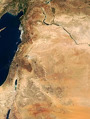
This true-color image of the region was taken on September 10, 2000, by the MODerate-resolution Imaging Spectroradiometer (MODIS) flying aboard NASA's Terra spacecraft. The image shows the lands of Israel along the eastern shore of the Mediterranean Sea, with the countries of Jordan to the southeast and Syria to the Northeast. The region known as the West Bank lies between the two countries. Running from north to south, the Jordan River links the Sea of Galilee to the Dead Sea. Click the image to enlarge it, and to see the borders drawn in. Image courtesy Jacques Descloitres, MODIS Land Group, NASA GSFC |
| Data | image taken on 10. Sep. 2000 |
| Font | http://earthobservatory.nasa.gov/Newsroom/NewImages/Images/modis_near_east_lrg.jpg |
| Autor | NASA, earthobservatory, http://earthobservatory.nasa.gov/ |
| Permission (Reütilizacion d'aqueste fichièr) |
PD-USGov-NASA |
| Aquest fitxer és en el domini públic perquè ha estat creat per la NASA. L'avís legal de la NASA diu que «el material de la NASA no està protegit per copyright si no es diu el contrari». (NASA copyright policy page o JPL Image Use Policy). | ||
 |
Atenció:
|
Istoric del fichièr
Clicar sus una data e una ora per veire lo fichièr tal coma èra a aqueste moment
| Data e ora | Miniatura | Dimensions | Utilizaire | Comentari | |
|---|---|---|---|---|---|
| actual | 5 febrièr de 2015 a 20.27 | | 2 987 × 3 967 (2,62 Mo) | Capricorn4049 (discussion | contribucions) | Cropped < 1 % horizontally and 1 % vertically using CropTool with precise mode. |
| 5 junh de 2005 a 09.29 |  | 3 002 × 4 002 (1,96 Mo) | Prolineserver (discussion | contribucions) | near east, PD-USGov-NASA |
Podètz pas remplaçar aqueste fichièr.
Paginas que contenon lo fichièr
Las paginas çaijós compòrtan aqueste imatge :
Usatge global del fichièr
Los autres wikis seguents utilizan aqueste imatge :
- Utilizacion sus ar.wikipedia.org
- Utilizacion sus arz.wikipedia.org
- Utilizacion sus ast.wikipedia.org
- Utilizacion sus ba.wikipedia.org
- Utilizacion sus ca.wikipedia.org
- Utilizacion sus ckb.wikipedia.org
- Utilizacion sus el.wikipedia.org
- Utilizacion sus en.wikipedia.org
- Utilizacion sus eo.wikipedia.org
- Utilizacion sus eo.wikiquote.org
- Utilizacion sus es.wikipedia.org
- Utilizacion sus eu.wikipedia.org
- Utilizacion sus fa.wikipedia.org
- Utilizacion sus fr.wikipedia.org
- Utilizacion sus gl.wikipedia.org
- Utilizacion sus he.wikipedia.org
- Utilizacion sus id.wikipedia.org
- Utilizacion sus is.wikipedia.org
- Utilizacion sus it.wikipedia.org
- Utilizacion sus ja.wikipedia.org
- Utilizacion sus kbp.wikipedia.org
- Utilizacion sus ko.wikipedia.org
Veire l'utilizacion globala d'aqueste fichièr.
Metadonadas
- Near East
- Photos of Asia by the Terra (satellite) MODIS
- Satellite pictures of Iraq
- Satellite pictures of Israel
- Satellite pictures of the State of Palestine
- Satellite pictures of the Palestinian territories
- Satellite pictures of Jordan
- Satellite pictures of Saudi Arabia
- Maps of Iraq
- Maps of Israel
- Maps of the Levant
- Maps of Jordan
- Maps of Saudi Arabia
- Geography of Syria
- Maps of Syria
- Satellite pictures of Syria
- Greater Israel