File:Nearctic-Eastern Canada.svg
Jump to navigation
Jump to search

Size of this PNG preview of this SVG file: 755 × 599 pixels. Other resolutions: 302 × 240 pixels | 605 × 480 pixels | 968 × 768 pixels | 1,280 × 1,016 pixels | 2,560 × 2,032 pixels.
Original file (SVG file, nominally 800 × 635 pixels, file size: 64 KB)
Captions
Captions
Add a one-line explanation of what this file represents
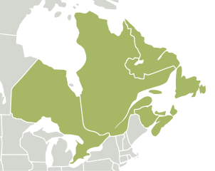
| Description | Map of Nearctic ecozone highlighting Eastern Canada as described by Plant Taxonomic Database Standards No. 2 [1] | ||||||||
| Date | |||||||||
| Source |
Selected from Ecozones and Image:North America second level political division 2 and Greenland.svgImage:BlankMap-World6, compact.svg by several people |
||||||||
| Author | carol | ||||||||
| Permission (Reusing this file) |
|

File history
Click on a date/time to view the file as it appeared at that time.
| Date/Time | Thumbnail | Dimensions | User | Comment | |
|---|---|---|---|---|---|
| current | 03:41, 2 May 2008 | | 800 × 635 (64 KB) | CarolSpears (talk | contribs) | |
| 11:29, 29 April 2008 |  | 1,789 × 2,154 (402 KB) | CarolSpears (talk | contribs) | {{Information |Description=Map of Nearctic ecozone highlighting Eastern Canada as described by Plant Taxonomic Database Standards No. 2 [http://www.tdwg.org/TDWG_geo2.pdf] |Source=Selected from [[:w:Ecozones| |
You cannot overwrite this file.
File usage on Commons
The following 2 pages use this file:
File usage on other wikis
The following other wikis use this file:
- Usage on ar.wikipedia.org
- Usage on azb.wikipedia.org
- Usage on be-tarask.wikipedia.org
- Usage on en.wikipedia.org
- Usage on tr.wikipedia.org
- Usage on ur.wikipedia.org