File:Neckar-Enz-Stellung Ende 2. WK.png
Jump to navigation
Jump to search

Size of this preview: 493 × 599 pixels. Other resolutions: 197 × 240 pixels | 395 × 480 pixels | 631 × 768 pixels | 842 × 1,024 pixels | 2,000 × 2,432 pixels.
Original file (2,000 × 2,432 pixels, file size: 2.39 MB, MIME type: image/png)
Captions
Captions
Add a one-line explanation of what this file represents
Summary[edit]
| Description |
|
|||
| Date | ||||
| Source | PNG conversion of Image:Neckar-Enz-Stellung_Ende 2. WK.svg | |||
| Author | K. Jähne, Ssch | |||
| Other versions |
|


Licensing[edit]
| This work is ineligible for copyright and therefore in the public domain because it consists entirely of information that is common property and contains no original authorship. |
File history
Click on a date/time to view the file as it appeared at that time.
| Date/Time | Thumbnail | Dimensions | User | Comment | |
|---|---|---|---|---|---|
| current | 12:46, 1 February 2009 | | 2,000 × 2,432 (2.39 MB) | Kjunix (talk | contribs) | fix front line of 1945-04-11 with data by Blumenstock: "Der Einmarsch der Amerikaner und Franzosen im nördlichen Württemberg im April 1945" |
| 20:09, 19 October 2008 |  | 2,000 × 2,432 (2.39 MB) | Kjunix (talk | contribs) | adding details, provided by Ssch | |
| 11:22, 12 October 2008 |  | 2,000 × 2,432 (633 KB) | Kjunix (talk | contribs) | typo, design improvements | |
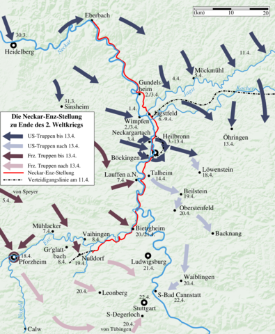
| 22:23, 23 May 2008 |  | 2,000 × 2,432 (614 KB) | Kjunix (talk | contribs) | == Description == {{Information| |Description = *{{de|Karte des Alliierten Einmarschs zu Ende des Zweiten Weltkriegs entlang der Neckar-Enz-Stellung.}} *{{en|map of end of 2nd wolrd war at Neckar-Enz bunker line.}} |Source = PNG conversion of [[:Image:Nec |
You cannot overwrite this file.
File usage on Commons
The following page uses this file:
File usage on other wikis
The following other wikis use this file:
- Usage on de.wikipedia.org