File:Neckar Fluss.jpg
Original file (3,512 × 1,976 pixels, file size: 1.45 MB, MIME type: image/jpeg)
Captions
Summary
[edit]DescriptionNeckar Fluss.jpg |
العربية: نهر النيكر هو أحد روافد نهر الراين في ألمانيا بطول 362 كم، معه أطول منبع في منطقة إيشاخ حتى 380 كم، والذي يصرف ما يقرب من 14000 كيلومتر مربع منطقة مستجمعات المياه ، الجزء المركزي من بادن-فورتيمبرغ.
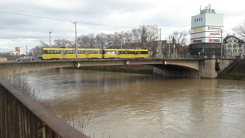
Deutsch: Rosensteinbrücke über den Neckar im Stuttgarter Stadtteil Bad Cannstadt |
Date | |
Source | Own work |
Author | Moayad Abuawad |
Camera location | 48° 48′ 18″ N, 9° 12′ 36″ E | View this and other nearby images on: OpenStreetMap | 48.805000; 9.210000 |
---|
Licensing
[edit]- You are free:
- to share – to copy, distribute and transmit the work
- to remix – to adapt the work
- Under the following conditions:
- attribution – You must give appropriate credit, provide a link to the license, and indicate if changes were made. You may do so in any reasonable manner, but not in any way that suggests the licensor endorses you or your use.
- share alike – If you remix, transform, or build upon the material, you must distribute your contributions under the same or compatible license as the original.
This image was uploaded as part of Wiki Loves Monuments 2018.
Afrikaans ∙ Alemannisch ∙ العربية ∙ جازايرية ∙ azərbaycanca ∙ Bikol Central ∙ беларуская ∙ беларуская (тарашкевіца) ∙ български ∙ বাংলা ∙ brezhoneg ∙ bosanski ∙ català ∙ čeština ∙ Cymraeg ∙ dansk ∙ Deutsch ∙ Zazaki ∙ Ελληνικά ∙ English ∙ Esperanto ∙ español ∙ eesti ∙ euskara ∙ فارسی ∙ suomi ∙ français ∙ Frysk ∙ Gaeilge ∙ galego ∙ עברית ∙ हिन्दी ∙ hrvatski ∙ magyar ∙ հայերեն ∙ Bahasa Indonesia ∙ Ido ∙ italiano ∙ 日本語 ∙ ქართული ∙ 한국어 ∙ кыргызча ∙ Lëtzebuergesch ∙ latviešu ∙ Malagasy ∙ македонски ∙ മലയാളം ∙ Bahasa Melayu ∙ Malti ∙ norsk bokmål ∙ नेपाली ∙ Nederlands ∙ norsk nynorsk ∙ norsk ∙ polski ∙ português ∙ português do Brasil ∙ română ∙ русский ∙ sicilianu ∙ davvisámegiella ∙ slovenčina ∙ slovenščina ∙ shqip ∙ српски / srpski ∙ svenska ∙ ไทย ∙ Tagalog ∙ Türkçe ∙ українська ∙ اردو ∙ oʻzbekcha / ўзбекча ∙ Yorùbá ∙ 中文 ∙ 中文(中国大陆) ∙ 中文(简体) ∙ 中文(繁體) ∙ 中文(香港) ∙ 中文(臺灣) ∙ +/− |
File history
Click on a date/time to view the file as it appeared at that time.
Date/Time | Thumbnail | Dimensions | User | Comment | |
---|---|---|---|---|---|
current | 16:01, 29 April 2023 | 3,512 × 1,976 (1.45 MB) | Jomarius (talk | contribs) | Ausschnitt | |
13:22, 8 September 2018 | 4,128 × 2,322 (3.7 MB) | Moayad Abuawad (talk | contribs) | User created page with UploadWizard |
You cannot overwrite this file.
File usage on Commons
The following page uses this file:
File usage on other wikis
The following other wikis use this file:
- Usage on de.wikipedia.org
- Usage on en.wikipedia.org
- Usage on www.wikidata.org
Metadata
This file contains additional information such as Exif metadata which may have been added by the digital camera, scanner, or software program used to create or digitize it. If the file has been modified from its original state, some details such as the timestamp may not fully reflect those of the original file. The timestamp is only as accurate as the clock in the camera, and it may be completely wrong.
Camera manufacturer | samsung |
---|---|
Camera model | SM-A510F |
Exposure time | 1/243 sec (0.0041152263374486) |
F-number | f/1.9 |
ISO speed rating | 40 |
Date and time of data generation | 14:50, 6 January 2018 |
Lens focal length | 3.7 mm |
User comments | IICSA |
Latitude | 48° 48′ 18″ N |
Longitude | 9° 12′ 36″ E |
Altitude | 266 meters above sea level |
Width | 4,128 px |
Height | 2,322 px |
Orientation | Normal |
Horizontal resolution | 72 dpi |
Vertical resolution | 72 dpi |
Software used | Windows Photo Editor 10.0.10011.16384 |
File change date and time | 18:01, 29 April 2023 |
Y and C positioning | Centered |
Exposure Program | Normal program |
Exif version | 2.2 |
Date and time of digitizing | 14:50, 6 January 2018 |
APEX shutter speed | 7.92 |
APEX aperture | 1.85 |
APEX brightness | 5.76 |
APEX exposure bias | 0 |
Maximum land aperture | 1.85 APEX (f/1.9) |
Metering mode | Center weighted average |
Flash | Flash did not fire |
Supported Flashpix version | 1 |
Color space | sRGB |
Exposure mode | Auto exposure |
White balance | Auto white balance |
Focal length in 35 mm film | 28 mm |
Scene capture type | Standard |
Unique image ID | U13LLIA00PM U13LLJC02SA |
GPS time (atomic clock) | 13:50 |
GPS date | 6 January 2018 |
GPS tag version | 2.2.0.0 |
Structured data
Items portrayed in this file
depicts
6 January 2018
48°48'18"N, 9°12'36"E
0.00411522633744855967 second
1.9
3.7 millimetre
image/jpeg
- Files with coordinates missing SDC location of creation (48° N, 9° E)
- CC-BY-SA-4.0
- Self-published work
- Images from Wiki Loves Monuments 2018
- Images from Wiki Loves Monuments 2018 in Germany
- Images from Wiki Loves Monuments missing SDC depicts
- Images from Wiki Loves Monuments missing SDC location of creation
- Images from Wiki Loves Monuments 2018, DE-BW
- Uploaded via Campaign:wlm-de-bw