File:Nemegtomaia maps.png
跳至導覽
跳至搜尋

預覽大小:800 × 407 像素。 其他解析度:320 × 163 像素 | 640 × 326 像素 | 1,024 × 521 像素 | 1,280 × 651 像素 | 3,397 × 1,729 像素。
原始檔案 (3,397 × 1,729 像素,檔案大小:4.66 MB,MIME 類型:image/png)
說明
說明
添加單行說明來描述出檔案所代表的內容
摘要
[編輯]
| 描述 |
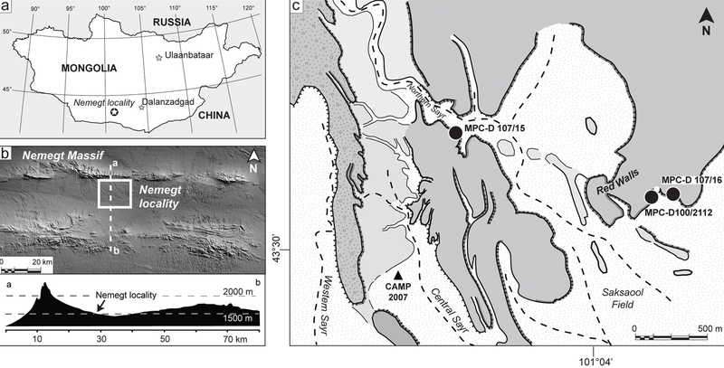
The Nemegt locality the Gobi Desert, southern Mongolia. A, map showing the location of the study area within southern Mongolia; B, the Nemegt area is located a few kilometers south of the massif of the same name; C, a detail of the Nemegt locality (sensu 5), showing the exact locations of Nemegtomaia specimens described in this study. |
| 日期 | |
| 來源 | http://www.plosone.org/article/info%3Adoi%2F10.1371%2Fjournal.pone.0031330 |
| 作者 | Federico Fanti, Philip J. Currie, Demchig Badamgarav |
授權條款
[編輯]
|
此檔案採用創用CC 姓名標示 2.5 通用版授權條款。
|
圖片審查員Dyolf77,確認本圖片於2016年3月30日可在下列站點找到並符合所選許可證:
http://www.plosone.org/article/info%3Adoi%2F10.1371%2Fjournal.pone.0031330 |
檔案歷史
點選日期/時間以檢視該時間的檔案版本。
| 日期/時間 | 縮圖 | 尺寸 | 使用者 | 備註 | |
|---|---|---|---|---|---|
| 目前 | 2018年10月24日 (三) 21:53 | | 3,397 × 1,729(4.66 MB) | FunkMonk(留言 | 貢獻) | Cropped 1 % horizontally, 1 % vertically using CropTool with precise mode. |
| 2016年9月8日 (四) 22:35 |  | 3,446 × 1,753(4.72 MB) | FunkMonk(留言 | 貢獻) | == {{int:filedesc}} == {{Information |Description=The Nemegt locality the Gobi Desert, southern Mongolia. A, map showing the location of the study area within southern Mongolia; B, the Nemegt area is located a few kilometers south of the massif of the... |
無法覆蓋此檔案。
檔案用途
沒有使用此檔案的頁面。
全域檔案使用狀況
以下其他 wiki 使用了這個檔案:
- de.wikipedia.org 的使用狀況
- en.wikipedia.org 的使用狀況
- es.wikipedia.org 的使用狀況
- fa.wikipedia.org 的使用狀況
- nl.wikipedia.org 的使用狀況
- pl.wikipedia.org 的使用狀況
- zh.wikipedia.org 的使用狀況