File:NeoHittiteStates.gif
Salta a la navegació
Salta a la cerca
No hi ha cap versió amb una resolució més gran.
NeoHittiteStates.gif (380 × 380 píxels, mida del fitxer: 16 Ko, tipus MIME: image/gif)
Llegendes
Llegendes
Afegeix una explicació d'una línia del que representa aquest fitxer
| Descripció |
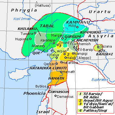
English: Historical map of the Neo-Hittite states (ca. 800 BCE). Based on data from Tübinger Bibelatlas (Tübinger Bible Atlas), S. Mittmann & G. Schmitt (eds.), maps B IV 13-14, and O.R. Gurney, The Hittites, Harmondsworth: Penguin (Pelican Books), 2nd ed., 1976 (=1954) pp. 39-46. "State borders" are approximate only. |
||||||||
| Data | |||||||||
| Font | http://en.wikipedia.org/wiki/Image:NeoHittiteStates.gif | ||||||||
| Autor | Hans van Deukeren (talk) | ||||||||
| Permís (Com reutilitzar aquest fitxer) |
|

Historial del fitxer
Cliqueu una data/hora per veure el fitxer tal com era aleshores.
| Data/hora | Miniatura | Dimensions | Usuari/a | Comentari | |
|---|---|---|---|---|---|
| actual | 10:15, 25 jul 2008 | | 380 × 380 (16 Ko) | Zunkir (discussió | contribucions) | {{Information |Description=Historical map of the Neo-Hittite states (ca. 800 BCE). Based on data from Tübinger Bibelatlas (Tübinger Bible Atlas), S. Mittmann & G. Schmitt (eds.), maps B IV 13-14, and O.R. Gurney, The Hittites, Harmondsworth: Penguin (Pe |
No podeu sobreescriure aquest fitxer.
Ús del fitxer
La pàgina següent utilitza aquest fitxer:
Ús global del fitxer
Utilització d'aquest fitxer en altres wikis:
- Utilització a als.wikipedia.org
- Utilització a ar.wikipedia.org
- Utilització a arz.wikipedia.org
- Utilització a azb.wikipedia.org
- Utilització a az.wikipedia.org
- Utilització a bg.wikipedia.org
- Utilització a bn.wikipedia.org
- Utilització a ca.wikipedia.org
- Utilització a de.wikipedia.org
- Utilització a el.wikipedia.org
- Utilització a en.wikipedia.org
Vegeu més usos globals d'aquest fitxer.