File:Neolithic central anatolia map 1.png

Original file (2,247 × 1,669 pixels, file size: 4.83 MB, MIME type: image/png)
Captions
Captions
Summary
[edit]
| Description |
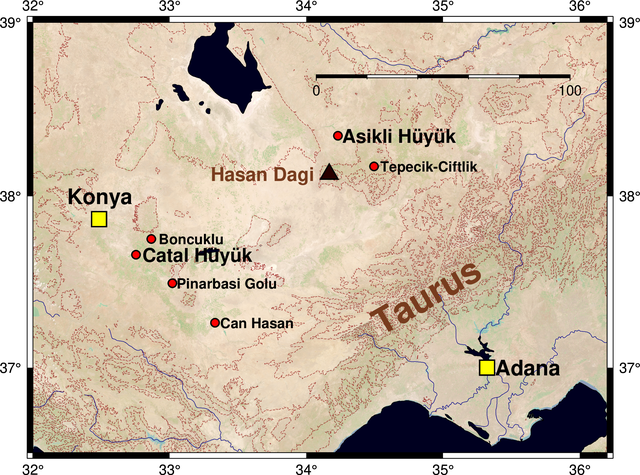
English: Some famous neolithic sites in Central Anatolia. |
| Date | |
| Source | Own work |
| Author | Merikanto |
Sources of locations wiki, geohack
Map data: Merit 250 m
World Imagery 150 m with QGIS capture
World_Imagery (MapServer) https://services.arcgisonline.com/ArcGIS/rest/services/World_Imagery/MapServer
https://zenodo.org/record/1447210 NASA Worldview NDVI data
GMT 6 code
rem
rem anatolia neolithic sites
rem gmt 6 script
rem 17.1.2021 v 0000.0001
rem rasters
rem merit 250 m dem
rem satellite images froom earthview
rem
gmt gmtset BASEMAP_TYPE = fancy
gmt grdcut ./grids/merit.nc -G./process/ahar2.nc -R32/36.2/36.5/39
gmt grdgradient ./process/ahar2.nc -G./process/hillshade-grad2.nc -A345 -Ne0.6 -V
gmt grdhisteq ./process/hillshade-grad2.nc -G./process/hillshade-hist2.nc -N -V
gmt grdmath ./process/hillshade-hist2.nc 5 DIV = ./process/hillshade-int2.nc
gmt makecpt -Crelief -T-7500/7500/500 -Z > topo.cpt
rem gmt grdimage ./process/ahar2.nc -R32/36.2/36/39 -Jm1.6i -B1 -Cpaletti.cpt -I./process/hillshade-int2.nc -P -K  > ./out/kartta.ps
rem
rem gmt grdimage ./grids/central_anatolia_image_1.tiff -I0.4 -R32/36.2/36.5/39 -Jm1.6i -B1  -P  -K > ./out/kartta.ps
rem gmt grdimage ./grids/ndvi2.tiff -I0.7 -R32/36.2/36.5/39 -Jm1.6i -B1  -P  -K > ./out/kartta.ps
gmt grdimage ./grids/karttadata1.tif -I0.7 -R32/36.2/36.5/39 -Jm1.6i -B1  -P  -K > ./out/kartta.ps
gmt grdcontour ./process/ahar2.nc -C500 -Wcthinnest,darkred@30,- -R -J -V -P -O -K >> ./out/kartta.ps
gmt pscoast -R -J -B -Df -Lf35/38.7/38.9/100km --LABEL_FONT_SIZE=18 -W1 -I1/1p,darkblue -N1/0.25p,- -I2/0.25p,darkblue -I3/0.25p,darkblue -I4/0.25p,darkblue -I5/0.25p,darkblue -I6/0.25p,darkblue -W0.25p,black -S0/0/32 -P -O -K >> ./out/kartta.ps
gmt psxy sites.txt -R -J -W1 -Sc0.25 -G255/0/0 -V -P -O -K >> ./out/kartta.ps
gmt pstext sitenames.txt -R -J -V -P -O -K >> ./out/kartta.ps
gmt psxy mountains.txt -R -J -St0.6 -W1 -G40/0/0 -V -P -O -K >> ./out/kartta.ps
gmt pstext mountainames.txt -F+f14,Helvetica-Bold,darkbrown -R -J -V -P -O -K >> ./out/kartta.ps
gmt psxy cities.txt -R -J -W1 -SS0.5 -G255/255/0 -V -P -O -K >> ./out/kartta.ps
gmt pstext citynames.txt -F+f14,,black@30  -R -J -V -P -O  >> ./out/kartta.ps
gmt psconvert ./out/kartta.ps -A -Tg
gmt psconvert ./out/kartta.ps -A -Tf
Paletti.cpt
-9000         100/100/200 	00     100/200/255
0          80/200/100 	100     100/200/100
100         100/200/100 	200     150/255/150
200 	150/255/150 	500 	255/255/150
500 	255/255/150 	1000 	255/200/80
1000 	255/200/80 	2000 	200/180/70
2000 	200/180/70 	4000 	185/130/55
4000 	185/130/55 	8000 	185/130/55
B	black
F	white
N	128
sitest.txt
32.7533 37.6600 14 0 1 LM Catal Hüyük
34.2300 38.3489 14 0 1 LM Asikli Hüyük
33.0192 37.4939 14 0 1 LM Pınarbası Gölü
32.8649 37.7517 14 0 1 LM Boncuklu
34.4942 38.1719 14 0 1 LM Tepecik-Ciftlik
33.3313 37.2630 12 0 1 LM Can Hasan
sitenames.txt
32.80 37.6600 16 0 1 LM Catal Hüyük
34.26 38.3489 16 0 1 LM Asikli Hüyük
33.05 37.4939 12 0 1 LM Pinarbasi Golu
32.92 37.7517 12 0 1 LM Boncuklu
34.54 38.1719 12 0 1 LM Tepecik-Ciftlik
33.37 37.2630 12 0 1 LM Can Hasan
mountains.txt
34.1667 38.1275 12 0 1 LM Hasan Dagi
mountainames.txt
33.3 38.1275 16 0 1 LM Hasan Dagi
34.5 37.25 30 30 1 LM Taurus
cities.txt
32.4833 37.8667 0 1 LM Konya
35.3213 37.0000 0 1 LM Adana
32.8644 39.9272 0 1 LM Ankara
30.6833 30.9000 0 1 LM Antalya
citynames.txt
32.2500 38.0 18 0 1 LM Konya
35.3800 37.0000 18 0 1 LM Adana
32.8644 39.9272 18 0 1 LM Ankara
30.6833 30.9000 18 0 1 LM Antalya
rectangle of map in csv
lon,lat
32,36.5
32,39
36.2,39
36.2,36.5
32,36.5
rectangle of map geojson, for qgis
{
"type": "FeatureCollection",
"name": "leikkuri0",
"crs": { "type": "name", "properties": { "name": "urn:ogc:def:crs:OGC:1.3:CRS84" } },
"features": [
{ "type": "Feature", "properties": { "lon": 32.0, "lat": 36.5, "area": 10.5, "perimeter": 13.4 }, "geometry": { "type": "Polygon", "coordinates": [ [ [ 32.0, 36.5 ], [ 32.0, 39.0 ], [ 36.2, 39.0 ], [ 36.2, 36.5 ], [ 32.0, 36.5 ] ] ] } }
]
}
Licensing
[edit]
- You are free:
- to share – to copy, distribute and transmit the work
- to remix – to adapt the work
- Under the following conditions:
- attribution – You must give appropriate credit, provide a link to the license, and indicate if changes were made. You may do so in any reasonable manner, but not in any way that suggests the licensor endorses you or your use.
- share alike – If you remix, transform, or build upon the material, you must distribute your contributions under the same or compatible license as the original.
File history
Click on a date/time to view the file as it appeared at that time.
| Date/Time | Thumbnail | Dimensions | User | Comment | |
|---|---|---|---|---|---|
| current | 13:28, 17 January 2021 | | 2,247 × 1,669 (4.83 MB) | Merikanto (talk | contribs) | Update of base image |
| 11:06, 16 January 2021 |  | 2,247 × 1,669 (2.05 MB) | Merikanto (talk | contribs) | Upload | |
| 13:05, 15 January 2021 |  | 2,247 × 1,965 (4.08 MB) | Merikanto (talk | contribs) | Uploaded own work with UploadWizard |
You cannot overwrite this file.
File usage on Commons
There are no pages that use this file.
File usage on other wikis
The following other wikis use this file:
- Usage on fi.wikipedia.org