File:NepalSindhupalchokDistrictmap.png
Alkuperäinen tiedosto (3 508 × 2 479 kuvapistettä, 370 KiB, MIME-tyyppi: image/png)
Kuvatekstit
Kuvatekstit
| Kuvaus |
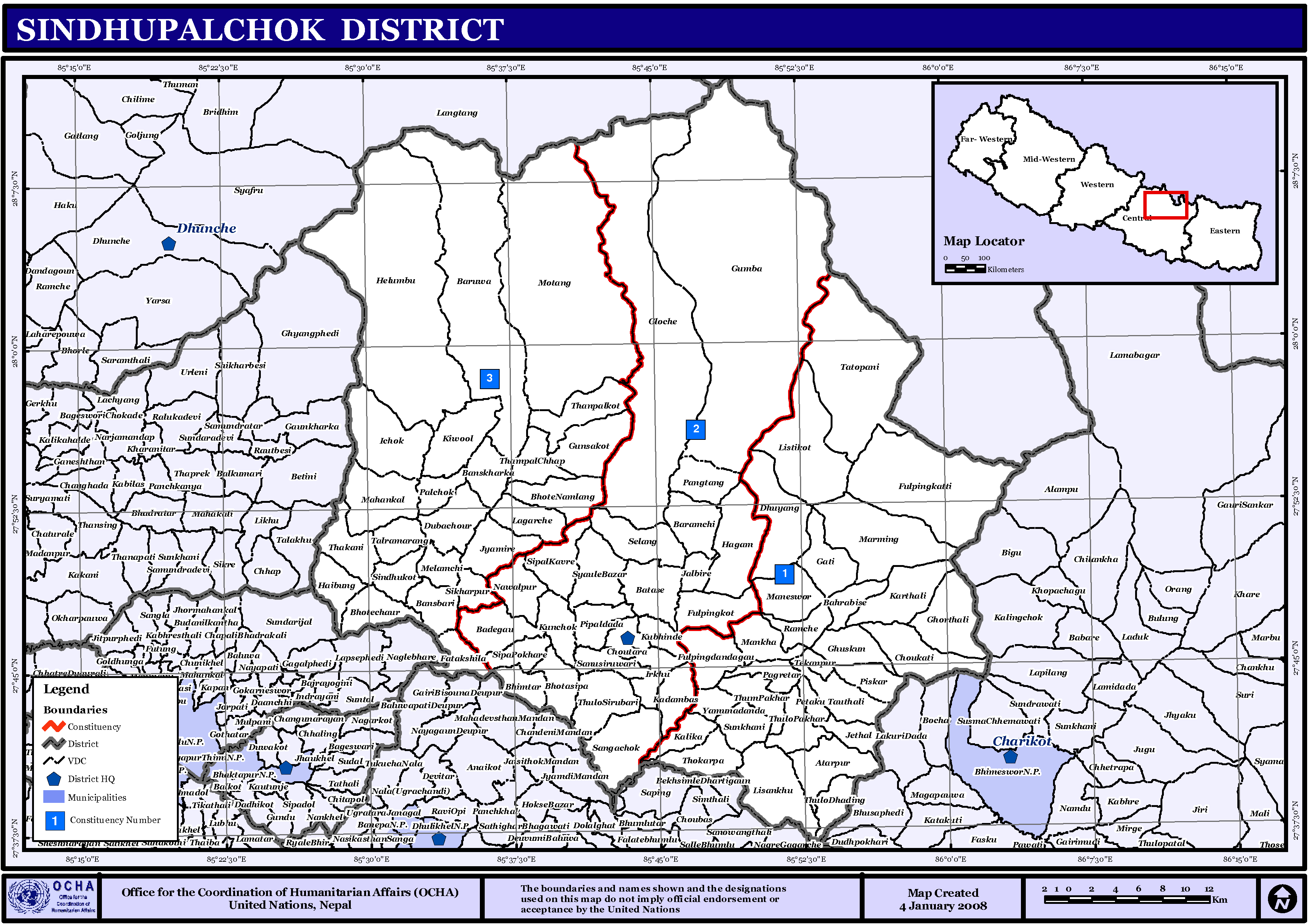
English: Map displaying Village Development Committees in Sindhupalchok District, Nepal |
| Päiväys | |
| Lähde | http://www.un.org.np/maps/district-maps/central/Sindhupalchok.pdf |
| Tekijä | United Nations |
Lisenssi
[muokkaa]
| This image is a map derived from a United Nations map.
Unless stated otherwise, UN maps are to be considered in the public domain. This applies worldwide. UN maps are, in principle, open source material and you can use them in your work or for making your own map. UN requests however that you delete the UN name, logo and reference number upon any modification to the map. Content of your map will be your responsibility. You can state in your publication, if you wish, something like: based on UN map … (map name, map number, revision number and date). See: Geospatial Information Section. And: Geospatial, location data for a better world. |
 |
Tiedoston historia
Päiväystä napsauttamalla näet, millainen tiedosto oli kyseisellä hetkellä.
| Päiväys | Pienoiskuva | Koko | Käyttäjä | Kommentti | |
|---|---|---|---|---|---|
| nykyinen | 15. marraskuuta 2008 kello 18.55 | | 3 508 × 2 479 (370 KiB) | Sadalmelik (keskustelu | muokkaukset) | {{Information |Description={{en|1=Map displaying Village Development Committees in Sindhupalchok District, Nepal}} |Source=http://www.un.org.np/maps/district-maps/central/Sindhupalchok.pdf |Date=January 4, 2008 |Author=United Nations |Permission= |ot |
Et voi tallentaa uutta tiedostoa tämän tilalle.
Tiedoston käyttö
Seuraava sivu käyttää tätä tiedostoa:
Tiedoston järjestelmänlaajuinen käyttö
Seuraavat muut wikit käyttävät tätä tiedostoa:
- Käyttö kohteessa bn.wikipedia.org
- Käyttö kohteessa de.wikipedia.org
- Käyttö kohteessa en.wikipedia.org
- Käyttö kohteessa fa.wikipedia.org
- Käyttö kohteessa fi.wikipedia.org
- Käyttö kohteessa fr.wikipedia.org
- Käyttö kohteessa it.wikipedia.org
- Käyttö kohteessa mai.wikipedia.org
- सिन्धुपाल्चोक जिला
- आकृति:सिन्धुपाल्चोक जिलाक गाविससभ
- चौतारा नगरपालिका
- मेलम्ची नगरपालिका
- अत्तरपुर
- इचोक
- इर्खु
- कदमबास
- कर्थली
- कालिका
- किउल
- कुन्चोक
- गाती
- गुन्साकोट
- गुम्बा
- गोल्चे
- घुमथाङ
- घोर्थली
- चोकटी
- जलबिरे
- जेठल
- टेकनपुर
- ठूलो धादिङ
- ठोकर्पा
- ठूलोपाखर
- तातोपानी
- तौथली
- थकनी
- थाम्पालकोट
- थाम्पालधाप
- थुम्पाखर
- ठूलोसिरुबारी
- दुबाचौर
- धुस्कुन
- पाङताङ
- नवलपुर
- पाल्चोक
- पांग्रेटार
- पिस्कर
- पेड्कु
Näytä lisää tämän tiedoston järjestelmänlaajuista käyttöä.