File:Nesenbach Verlauf.png
Jump to navigation
Jump to search
No higher resolution available.
Nesenbach_Verlauf.png (780 × 509 pixels, file size: 830 KB, MIME type: image/png)
Captions
Captions
Add a one-line explanation of what this file represents
| Description |
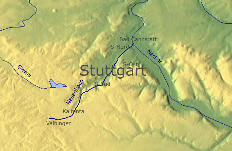
Deutsch: Relief-Karte im Raum Stuttgart , Nesenbach zentriert. |
||
| Date | |||
| Source | Relief aus Maps For Free, Openstreetmap | ||
| Author | Own work, Openstreetmap | ||
| Permission (Reusing this file) |
I, the copyright holder of this work, hereby publish it under the following licenses:
This file is licensed under the Creative Commons Attribution 3.0 Unported license.
You may select the license of your choice. |

File history
Click on a date/time to view the file as it appeared at that time.
| Date/Time | Thumbnail | Dimensions | User | Comment | |
|---|---|---|---|---|---|
| current | 12:49, 27 February 2017 | | 780 × 509 (830 KB) | Bigbossfarin (talk | contribs) | {{Information |Description ={{de|1=Relief-Karte im Raum Stuttgart , Nesenbach zentriert.}} |Source =Relief aus [http://www.maps-for-free.com/ Maps For Free], Openstreetmap |Author ={{own}} |Date =2017-02-27 |Permission... |
You cannot overwrite this file.
File usage on Commons
The following page uses this file:
File usage on other wikis
The following other wikis use this file:
- Usage on arz.wikipedia.org
- Usage on da.wikipedia.org
- Usage on de.wikipedia.org
- Usage on www.wikidata.org