File:Neufrankreich.svg
跳转到导航
跳转到搜索

此SVG文件的PNG预览的大小:800 × 570像素。 其他分辨率:320 × 228像素 | 640 × 456像素 | 1,024 × 730像素 | 1,280 × 912像素 | 2,560 × 1,824像素 | 1,530 × 1,090像素。
原始文件 (SVG文件,尺寸为1,530 × 1,090像素,文件大小:694 KB)
说明
说明
添加一行文字以描述该文件所表现的内容
摘要
[编辑]| 描述 |
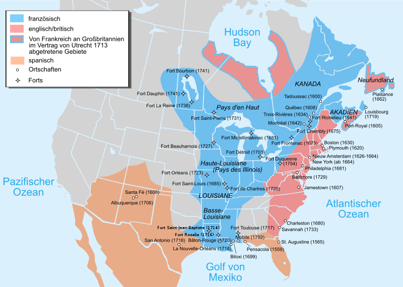
Català: Mapa de la Nova França sobre 1754-1755 English: Map of New France about 1750 using modern political boundaries Español: Mapa de la Nueva Francia cerca de 1750. Français : Carte de la Nouvelle-France vers 1754-1755 Norsk nynorsk: Kart over Ny Frankrike (ca 1754-1755) Русский: Карта Французских колоний в Америке 1750 中文(中国大陆): 1750年左右的新法兰西地图,附现代边界。 العربية : خريطة فرنسا الجديدة حوالي عام 1750 باستخدام الحدود السياسية الحديثة |
||
| 日期 | (UTC) | ||
| 来源 |
本檔案衍生自:
EquiDistantConicProjection : Central parallel : * N: 37.0° N Central meridian : * E: 96.0° W Standard parallels: * 1: 32.0° N * 2: 42.0° N Made with Natural Earth. Free vector and raster map data @ naturalearthdata.com. Formulas for x and y: x = 50.0 + 124.03149777329222 * ((1.9694462586094064-({{{2}}}* pi / 180)) * sin(0.6010514667026994 * ({{{3}}} + 96) * pi / 180)) y = 50.0 + 1.6155950752393982 * 124.03149777329222 * 0.02613325650382181 - 1.6155950752393982 * 124.03149777329222 * (1.3236744353715044 - (1.9694462586094064-({{{2}}}* pi / 180)) * cos(0.6010514667026994 * ({{{3}}} + 96) * pi / 180))
|
||
| 作者 |
|
||
| 其他版本 |
[]
|


| 这是一张修改过的图片,这意味着它已在原版本的基础上通过软件进行了编辑,改动内容:added Mexico, translated to German。其原始版本为:Usa edcp location map.svg。修改者:Bamse。
|
许可协议
[编辑]
本文件采用知识共享署名-相同方式共享 3.0 未本地化版本许可协议授权。
- 您可以自由地:
- 共享 – 复制、发行并传播本作品
- 修改 – 改编作品
- 惟须遵守下列条件:
- 署名 – 您必须对作品进行署名,提供授权条款的链接,并说明是否对原始内容进行了更改。您可以用任何合理的方式来署名,但不得以任何方式表明许可人认可您或您的使用。
- 相同方式共享 – 如果您再混合、转换或者基于本作品进行创作,您必须以与原先许可协议相同或相兼容的许可协议分发您贡献的作品。
原始上传日志
[编辑]
This image is a derivative work of the following images:
- File:Nouvelle-France_map-fr.svg licensed with Cc-by-sa-3.0,2.5,2.0,1.0, GFDL
- 2011-12-03T22:43:05Z JF Lepage 1530x1090 (333614 Bytes) Reverted to version as of 18:04, 13 November 2007
- 2011-12-01T12:21:39Z Hypersite 1550x1100 (348037 Bytes) Agrandie
- 2011-12-01T12:19:24Z Hypersite 1530x1090 (348037 Bytes) Agrandie
- 2011-12-01T12:15:49Z Hypersite 744x1052 (347994 Bytes) Vraie taille de la Nouvelle-France, Version améliorée,Ajout de 80 sources pour un délimitation des frontière la plus exacte possible. (Quand a la polémique disant que sont territoire s'étendait jusque en Oregon et Oc�
- 2011-12-01T12:12:54Z Hypersite 744x1052 (347978 Bytes) Vraie taille de la Nouvelle-France, Version améliorée,Ajout de 80 sources pour un délimitation des frontière la plus exacte possible. (Quand a la polémique disant que sont territoire s'étendait jusque en Oregon et Oc�
- 2007-11-13T18:04:41Z Pinpin 1530x1090 (333614 Bytes) illinois=>Illinois
- 2007-10-20T08:10:28Z Pinpin 1530x1090 (333613 Bytes)
- 2007-10-10T18:59:28Z Pinpin 1530x1090 (333619 Bytes)
- 2007-10-10T07:48:33Z Pinpin 1530x1090 (333620 Bytes)
- 2007-10-05T06:26:34Z Pinpin 1530x1090 (333485 Bytes)
- 2007-10-04T23:51:17Z Pinpin 1530x1090 (334013 Bytes)
- 2007-10-04T23:49:21Z Pinpin 1530x1090 (334112 Bytes) + legend
- 2007-10-04T23:38:23Z Pinpin 1530x1090 (326455 Bytes) {{Information |Description={{fr|Carte de la Nouvelle-France vers 1750}} {{en|Map of the New-France about 1750.}} |Source=travail personnel from [[:Image:Nouvelle-France1750.png]] 1)Les Villes françaises du Nouveau Monde : de
- File:Usa_edcp_location_map.svg licensed with Cc-by-sa-3.0, GFDL
- 2010-08-24T17:56:50Z Uwe Dedering 1181x731 (2691477 Bytes) coastline was to thin and bahamas pulled out of the atlantic
- 2010-08-24T10:35:14Z Uwe Dedering 1181x731 (3648408 Bytes) {{Information |Description={{en|1=Location map of the USA (without Hawaii and Alaska). EquiDistantConicProjection : Central parallel : * N: 37.0° N Central meridian : * E: 96.0° W Standard parallels: * 1: 32.0° N * 2:
Uploaded with derivativeFX
文件历史
点击某个日期/时间查看对应时刻的文件。
| 日期/时间 | 缩略图 | 大小 | 用户 | 备注 | |
|---|---|---|---|---|---|
| 当前 | 2022年12月14日 (三) 16:12 | | 1,530 × 1,090(694 KB) | Tcr25(留言 | 贡献) | Fort Rosaile in wrong location; add Fort St-Jean-Baptiste |
| 2013年10月9日 (三) 00:20 |  | 1,530 × 1,090(924 KB) | Furfur(留言 | 贡献) | Schraffur ist verlorengegangen, stattdessen vielleicht Umrandung ? | |
| 2013年10月8日 (二) 23:31 |  | 1,530 × 1,090(902 KB) | Furfur(留言 | 贡献) | kosmetische Änderungen (Diskussion Kartenwerkstatt) | |
| 2012年1月31日 (二) 14:14 |  | 1,530 × 1,090(316 KB) | Bamse(留言 | 贡献) | update per comments in Kartenwerkstatt | |
| 2012年1月29日 (日) 20:40 |  | 1,530 × 1,090(316 KB) | Bamse(留言 | 贡献) | error fixes per discussion in Kartenwerkstatt | |
| 2012年1月28日 (六) 21:05 |  | 1,530 × 1,090(316 KB) | Bamse(留言 | 贡献) | extended Spain to Mexico, added some towns and fixed some errors | |
| 2012年1月28日 (六) 10:54 |  | 1,530 × 1,090(307 KB) | Bamse(留言 | 贡献) | == {{int:filedesc}} == {{Information |Description={{fr|Carte de la Nouvelle-France vers 1750 - version française}} {{en|Map of the New-France about 1750 - French Version}} {{en|1=Location map of the USA (without Hawaii and Alaska). EquiDistantConicProjec |
您不可以覆盖此文件。
文件用途
以下12个页面使用本文件:
- File:Neufrankreich.svg
- File:Nouvelle-France map-ar.svg
- File:Nouvelle-France map-ca.svg
- File:Nouvelle-France map-en.svg
- File:Nouvelle-France map-es.svg
- File:Nouvelle-France map-fr.svg
- File:Nouvelle-France map-he.svg
- File:Nouvelle-France map-ru.svg
- File:Nouvelle-France map-zh-hans.svg
- File:USA edcp location map lite.svg
- File:Usa edcp location map.svg
- Template:Other versions/Nouvelle-France map
全域文件用途
以下其他wiki使用此文件:
- de.wikipedia.org上的用途
- Shawnee
- Neufrankreich
- Louisiana (Kolonie)
- Miami (Volk)
- Indianerkriege
- Siebenjähriger Krieg in Nordamerika
- Onondaga
- Fort Michilimackinac
- Winnebago (Volk)
- Geschichte Québecs
- Wirtschaftsgeschichte Kanadas
- Geschichte Louisianas
- Wikipedia:Kartenwerkstatt/Archiv/2012-02
- Menominee (Volk)
- Wikipedia:Kartenwerkstatt/Archiv/2013-10
- Schweizer Truppen in französischen Diensten für das Königshaus der Bourbonen 1589–1792
- The Jesuit Relations and Allied Documents
- Beziehungen zwischen Kanada und den Vereinigten Staaten
- en.wikipedia.org上的用途
- it.wikipedia.org上的用途
元数据
分类:
- Maps of New France
- Maps of colonial North America
- Maps of the history of Canada
- Maps of the history of the United States
- Maps of the Viceroyalty of New Spain
- SVG maps of the history of Mexico
- Locator maps of former territories
- North America in the 1750s
- Canada in the 1750s
- United States in the 1750s
- New Mexico in the 1750s
- French and Indian War
- Treaty of Utrecht