Userboxes
This user has been on Commons for 18 years, 10 months, and 3 days .
This user's timezone is UTC−5
{{Wiki}} This user can write in the MediaWiki language.
<html > This user can write HTML .
I guess the easiest thing to do is to look at my description on w:en ...
The Robert N. Broadbent
Las Vegas Monorail , Sahara Station
North Sea oil rigs in Cromarty Firth (
Scotland )
Gingerbread House, 2003
Assassin Bug (Zelus spp. )
The Strathpeffer Eagle Stone (Clach an Tiompain) (
Scotland )
Loch an Eilein castle ruins (
Scotland )
The Smithsonian Castle (
Washington, DC )
Loch Lochy (
Scotland ) as viewed from the A82
The Hammond Oak in Hammond,
Louisiana (2004)
The Hammond Oak in Hammond,
Louisiana (2023)
The Lake Pontchartrain Causeway (
Louisiana ), heading south toward
New Orleans
1924 Berliner Helicopter
Sangfroid Maryland Rye whiskey
Santa Muerte votive candles at a grocery store in suburban
Washington, D.C.
Accelerated loading truck at the National Center for Asphalt Technology
A scenario from the Metagaming version of The Fantasy Trip Death Test
Stone Cottage C at Spring Grove Hospital Center in Catonsville, Maryland
Robert "King" Hooper (1769) by John Singleton Copley
Scarlet-chested parrot at the Las Vegas Zoo
Old Dunfierth Chapel Ruins
Her name is Lucy
His name is Pistachio
[ edit ] Many of these are vector (SVG) file updates to preëxisting JPG or PNG files or other derivative works, as well as some experimenting with going from KML map files to SVG graphics.
U.S. population growth by state and territory from 1970 to 2020
2022 U.S. Gubernatorial Elections
2021 U.S. Gubernatorial Elections
2021 U.S. House Special Elections
2020 Wyoming State Senate Elections
New Orleans–Metairie–Hammond, LA–MS Combined Statistical Area (2012–July 2023)
New Orleans–Metairie–Slidell, LA–MS Combined Statistical Area (from July 2023)
Boundaries of the Five Tribes in 1866
Oklahoma Tribal Statistical Areas
Seminole OSTA
Muscogee (Creek) OSTA
Choctaw OSTA
Chickasaw OSTA
Cherokee OSTA
Louisiana Redbone cultural area
Jurisdictions under Section 5 oversight at time of Shelby v. Holder decision (2013)
Digital Television in South America
Kingdom of Hejaz and Nejd (1926–1932)
A megahex map polygon
Flag of the City of Hyattsville, Maryland
Flag of the Northern Ireland Assembly
Natchitoches Tribe of Louisiana flag
United Houma Nation flag
Flag-map of Antarctica (True South Flag)
Flag-map of the French Overseas Territory Kerguelen Islands
Shape map of Northern Ireland
Shape map of Germany with the länder in various colors
Flag-map of U.S. Minor Outlying Island Wake Island
Flag-map of U.S. Minor Outlying Island Midway Atoll
Updated Wikiproject logo to better represent a diverse community of editors
Logo for a new barnstar to recognize work improving articles about Louisiana
Updated Wikiproject Editor Retention barnstar to reflect new logo
[ edit ] Most of these are vector (SVG) file updates to preëxisting JPG or PNG files.
Combining signs for Cyrillic thousands
Cyrillic thousands marker
Cyrillic ten thousands marker
Cyrillic hundred thousands marker
Cyrillic millions marker
Cyrillic ten millions marker
Cyrillic hundred millions marker
Cyrillic billions marker
The year 1706 in Cyrillic numerals
The year 1280 in Glagolitic numerals
pIqaD, the Klingon script
Pentimal Runes 1 through 10
Cherokee numerals 2 and 10
Cherokee numeral 20
The number 504 written in Cherokee numerals
The number 64 written in Cherokee numerals
Ki-ka-ku in Mende Kikakui script
Mɛnde yia in Mende Kikakui script
[ edit ]
Comet Rosa (1460) from the 1587 Kometenbuch
Diceño de Mulata (1711) by Manuel de Arellano
Portrait of Francisco Bouligny (c. 1775) by unknown
Francisco Bouligny's signature
Andrés Almonaster y Roxas de Estrada (1796) by José Francisco Xavier de Salazar y Mendoza
Sebastián Calvo de la Puerta y O'Farrill (c. 1800) by José Francisco Xavier de Salazar y Mendoza
Haitian royal children: Victor Henry, Améthyste, Athénaïre (c. 1811) by unknown
Van Perkins Winder (c. 1830) by unknown
Judah Philip Benjamin (1835) by Adolph Rinck
Portrait of a Creole Woman with Madras Tignon (c. 1837) attributed to Jacques Amans
Chief Rabbi of Denmark A.A. Wolff (1854) by Edvard Fortling & David Monies
Uncle Tom: A Study from Life (c. 1856) by Thomas Uwins
Catherine Norton Nicholas Brune (1856) by Thomas Waterman Wood
Watercolor portrait of Mary Elizabeth Parker Bouligny (1860) by Henry Ulke
Guano Miners at Chincha, Peru (bef. 1865)
The Strangers’ Room, Bell Rock (1865) by R. M. Ballantyne
Navassa Island (c. 1870) by unknown
Engraving of The Louise Home in Washington, D.C.
Engraving of The Corcoran Gallery of Art
Engraving of W.W. Corcoran
Marie Laveau (1885) by E. W. Kemble
Engraving of
Postcard (c. 1890) of the Mexican Wild Man (George Stull) by Frank Wendt
Postcard (1892) of Lady Aama (Emma Bataillard), Josepha, and an unidentified woman by Frank Wendt
La Comtesse Mathieu de Noailles (1899) by Antonio de la Gandara
Sketch of Clipperton Rock (c. 1899), after a photograph
Charles Philippe Aubry (c. 1905) by Isnard Osicran
War of the Triple Alliance battle painting (before 1909) by Adolf Methfessel
Pierre-Clément de Laussat (c. 1911) by Andreas Molinary after a 1786 painting by Jean-François Gilles Colson.
Mills Thompson posing as Dante for Violet Oakley
Josephine the Bear
Don Carlos de Hault de Lassus (1916) by Charles Wellington Boyle
Neaderthal Flintworkers, Le Moustier (1920) by Charles R. Knight
Bluebeard's Last Wife (1921) by Harry Clarke
Gone is the Ancient Alchemist (1925) by Harry Clarke
The Two Distilleries on the Same Hill (1925) by Harry Clarke
Chief Rabbi of Denmark Dr. T. Lewenstein
Navassa Island (1930) by Alexander Wetmore
The trapeze-and-hoist system on the USS Macon
AP artist's conception of the crash of the USS Macon (1935) by Noel Sickles
Manuel Gayoso de Lemos (1942) by Pedro J. de Lemos
Pan Am Executive Bill Mullahey
Soviet poets Fatix Xösni, Äxmät İsxaq, and Mustai Karim
FERC fish ladder safety sign
U.S. Geological Survey map of the Chesapeake Bay watershed
Denil fishway on Salmon Creek (
Montana )
U.S. government Historical Building Survey Photo of KEAD radio on Wake Island
U.S. Army Corps of Engineers map of the Anacostia River watershed
U.S. Airforce Photo of Wilkes Island, Wake Atoll
Dick Spottswood
The Story of the Golden Fleece (1903) by Andrew Lang
A Tribute to W.W. Corcoran, of Washington City (1874) by Mary Elizabeth Parker Bouligny
What Is Unconditional Unionism? (1863) by Michael Hahn
Lassat's 1803 letter to The Cabildo
Laussat's 1803 proclamation regarding the restoration of Louisiana to the French Republic
1868 Advertisement for Alta Vela Guano Co. Fertilizer
Ticket from Bill Clinton's first inauguration
Library card from DC Public Library
5,000,000 Mark Reichsbank note (1923, obverse)
5,000,000 Mark Reichsbank note (1923, reverse)
5 krónur note (1928, obverse)
5 krónur note (1928, reverse)
See also User:Tcr25/Sleuthing
Found better sourcing/licensing information for the images sufficient to save them from deletion.
These images were updated to improve their quality, information, and/or licensing.

 North Sea oil rigs in Cromarty Firth (Scotland)
 Gingerbread House, 2003
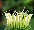 Assassin Bug (Zelus spp.)
 The Strathpeffer Eagle Stone (Clach an Tiompain) (Scotland)
 Loch an Eilein castle ruins (Scotland)
 The Smithsonian Castle (Washington, DC)
 Loch Lochy (Scotland) as viewed from the A82
 The Hammond Oak in Hammond, Louisiana (2004)
 The Hammond Oak in Hammond, Louisiana (2023)
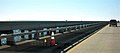 The Lake Pontchartrain Causeway (Louisiana), heading south toward New Orleans
 1924 Berliner Helicopter
 Sangfroid Maryland Rye whiskey
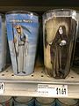 Santa Muerte votive candles at a grocery store in suburban Washington, D.C.
 Accelerated loading truck at the National Center for Asphalt Technology
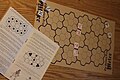 A scenario from the Metagaming version of The Fantasy Trip Death Test
 Stone Cottage C at Spring Grove Hospital Center in Catonsville, Maryland
 Robert "King" Hooper (1769) by John Singleton Copley
 Scarlet-chested parrot at the Las Vegas Zoo
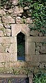 Old Dunfierth Chapel Ruins
 Her name is Lucy
 His name is Pistachio


.jpg)


 U.S. population growth by state and territory from 1970 to 2020
 2022 U.S. Gubernatorial Elections
 2021 U.S. Gubernatorial Elections
 2021 U.S. House Special Elections
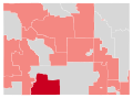 2020 Wyoming State Senate Elections
 New Orleans–Metairie–Hammond, LA–MS Combined Statistical Area (2012–July 2023)
 New Orleans–Metairie–Slidell, LA–MS Combined Statistical Area (from July 2023)
 Boundaries of the Five Tribes in 1866
 Oklahoma Tribal Statistical Areas
 Seminole OSTA
 Muscogee (Creek) OSTA
 Choctaw OSTA
 Chickasaw OSTA
 Cherokee OSTA
 Louisiana Redbone cultural area
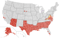 Jurisdictions under Section 5 oversight at time of Shelby v. Holder decision (2013)
 Digital Television in South America
 Kingdom of Hejaz and Nejd (1926–1932)
 A megahex map polygon
 Flag of the City of Hyattsville, Maryland
 Flag of the Northern Ireland Assembly
 Natchitoches Tribe of Louisiana flag
 United Houma Nation flag
 Flag-map of Antarctica (True South Flag)
 Flag-map of the French Overseas Territory Kerguelen Islands
 Shape map of Northern Ireland
 Shape map of Germany with the länder in various colors
 Flag-map of U.S. Minor Outlying Island Wake Island
 Flag-map of U.S. Minor Outlying Island Midway Atoll
 Updated Wikiproject logo to better represent a diverse community of editors
 Logo for a new barnstar to recognize work improving articles about Louisiana
 Updated Wikiproject Editor Retention barnstar to reflect new logo


.svg)


 Combining signs for Cyrillic thousands
 Cyrillic thousands marker
 Cyrillic ten thousands marker
 Cyrillic hundred thousands marker
 Cyrillic millions marker
 Cyrillic ten millions marker
 Cyrillic hundred millions marker
 Cyrillic billions marker
 The year 1706 in Cyrillic numerals
 The year 1280 in Glagolitic numerals
 pIqaD, the Klingon script
 Pentimal Runes 1 through 10
 Cherokee numerals 2 and 10
 Cherokee numeral 20
 The number 504 written in Cherokee numerals
 The number 64 written in Cherokee numerals
 Ki-ka-ku in Mende Kikakui script
 Mɛnde yia in Mende Kikakui script


 Comet Rosa (1460) from the 1587 Kometenbuch
 Diceño de Mulata (1711) by Manuel de Arellano
 Portrait of Francisco Bouligny (c. 1775) by unknown
 Francisco Bouligny's signature
 Andrés Almonaster y Roxas de Estrada (1796) by José Francisco Xavier de Salazar y Mendoza
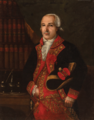 Sebastián Calvo de la Puerta y O'Farrill (c. 1800) by José Francisco Xavier de Salazar y Mendoza
 Haitian royal children: Victor Henry, Améthyste, Athénaïre (c. 1811) by unknown
 Van Perkins Winder (c. 1830) by unknown
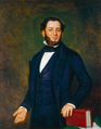 Judah Philip Benjamin (1835) by Adolph Rinck
 Portrait of a Creole Woman with Madras Tignon (c. 1837) attributed to Jacques Amans
 Chief Rabbi of Denmark A.A. Wolff (1854) by Edvard Fortling & David Monies
 Uncle Tom: A Study from Life (c. 1856) by Thomas Uwins
 Catherine Norton Nicholas Brune (1856) by Thomas Waterman Wood
 Watercolor portrait of Mary Elizabeth Parker Bouligny (1860) by Henry Ulke
 Guano Miners at Chincha, Peru (bef. 1865)
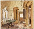 The Strangers’ Room, Bell Rock (1865) by R. M. Ballantyne
 Navassa Island (c. 1870) by unknown
 Engraving of The Louise Home in Washington, D.C.
 Engraving of The Corcoran Gallery of Art
 Engraving of W.W. Corcoran
 Marie Laveau (1885) by E. W. Kemble
 Engraving of
 Postcard (c. 1890) of the Mexican Wild Man (George Stull) by Frank Wendt
 Postcard (1892) of Lady Aama (Emma Bataillard), Josepha, and an unidentified woman by Frank Wendt
 La Comtesse Mathieu de Noailles (1899) by Antonio de la Gandara
 Sketch of Clipperton Rock (c. 1899), after a photograph
 Charles Philippe Aubry (c. 1905) by Isnard Osicran
 War of the Triple Alliance battle painting (before 1909) by Adolf Methfessel
 Pierre-Clément de Laussat (c. 1911) by Andreas Molinary after a 1786 painting by Jean-François Gilles Colson.
 Mills Thompson posing as Dante for Violet Oakley
 Josephine the Bear
 Don Carlos de Hault de Lassus (1916) by Charles Wellington Boyle
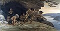 Neaderthal Flintworkers, Le Moustier (1920) by Charles R. Knight
 Bluebeard's Last Wife (1921) by Harry Clarke
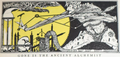 Gone is the Ancient Alchemist (1925) by Harry Clarke
 The Two Distilleries on the Same Hill (1925) by Harry Clarke
 Chief Rabbi of Denmark Dr. T. Lewenstein
 Navassa Island (1930) by Alexander Wetmore
 The trapeze-and-hoist system on the USS Macon
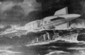 AP artist's conception of the crash of the USS Macon (1935) by Noel Sickles
 Manuel Gayoso de Lemos (1942) by Pedro J. de Lemos
 Pan Am Executive Bill Mullahey
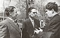 Soviet poets Fatix Xösni, Äxmät İsxaq, and Mustai Karim
 FERC fish ladder safety sign
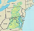 U.S. Geological Survey map of the Chesapeake Bay watershed
 Denil fishway on Salmon Creek (Montana)
 U.S. government Historical Building Survey Photo of KEAD radio on Wake Island
 U.S. Army Corps of Engineers map of the Anacostia River watershed
 U.S. Airforce Photo of Wilkes Island, Wake Atoll
 Dick Spottswood
.png)
_Arellano.jpg)


.png)

_by_Thomas_Uwins.jpg)


_Moulton.jpg)
.jpg)


.png)
.jpg)
.jpg)
.jpg)


_by_Andres_Molinary.jpg)


_by_Boyle_(1916).jpg)
.jpg)
_Harry_Clarke.jpg)
.png)
.png)


.jpg)

 The Story of the Golden Fleece (1903) by Andrew Lang
 A Tribute to W.W. Corcoran, of Washington City (1874) by Mary Elizabeth Parker Bouligny
 What Is Unconditional Unionism? (1863) by Michael Hahn
 Lassat's 1803 letter to The Cabildo
 Laussat's 1803 proclamation regarding the restoration of Louisiana to the French Republic
 1868 Advertisement for Alta Vela Guano Co. Fertilizer
 Ticket from Bill Clinton's first inauguration
 Library card from DC Public Library
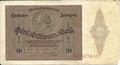 5,000,000 Mark Reichsbank note (1923, obverse)
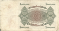 5,000,000 Mark Reichsbank note (1923, reverse)
 5 krónur note (1928, obverse)
 5 krónur note (1928, reverse)
.jpg)

.jpg)


_from_1928.png)
_from_1928.png)


.jpg)


.jpg)
_Carte_de_l%27attaque_du_fort_des_Natchez_par_les_Fran%C3%A7ais_en_1731,_lev%C3%A9e_g%C3%A9om%C3%A9triquement_sur_les_lieux_lors_de_la_destruction._(Bas)_Route_emprunt%C3%A9e_pour_l%27attaque,_lev%C3%A9e_%C3%A0_la_boussole_et_%C3%A0_l%27estime.jpg)


.jpg)


.jpg)


.jpg)


.jpg)
.png)


.jpg)


.png)


