File:New Brunswick-map.png
Pāriet uz navigāciju
Pāriet uz meklēšanu
Augstāka izšķirtspēja nav pieejama.
New_Brunswick-map.png (280 × 230 pikseļi, faila izmērs: 14 KB, MIME tips: image/png)
Captions
Captions
Pievieno vienas rindiņas aprakstu, ko šis fails attēlo
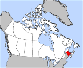
Map of New Brunswick
Projection: Wideload azimuthal equal-area
Geospatial data from: The Atlas of Canada, The National Atlas of the United States and U.S. Geological Survey
Cartographer: John Fowler
| I, the copyright holder of this work, release this work into the public domain. This applies worldwide. In some countries this may not be legally possible; if so: I grant anyone the right to use this work for any purpose, without any conditions, unless such conditions are required by law. |
Faila hronoloģija
Uzklikšķini uz datums/laiks kolonnā esošās saites, lai apskatītos, kā šis fails izskatījās tad.
| Datums/Laiks | Attēls | Izmēri | Dalībnieks | Komentārs | |
|---|---|---|---|---|---|
| tagadējais | 2005. gada 24. marts, plkst. 12.13 | | 280 × 230 (14 KB) | Voyager (diskusija | devums) | Map of New Brunswick Projection: Lambert azimuthal equal-area Geospatial data from: [http://atlas.gc.ca/ The Atlas of Canada], [http://www.nationalatlas.gov/ The National Atlas of the United States] and [http://www.usgs.gov U.S. Geological Survey] Cart |
Šo failu nevar pārrakstīt.
Faila lietojums
Šo failu izmanto šajās 2 lapās:
Globālais faila lietojums
Šīs Vikipēdijas izmanto šo failu:
- Izmantojums bat-smg.wikipedia.org
- Izmantojums br.wikipedia.org
- Izmantojums cy.wikipedia.org
- Izmantojums de.wikipedia.org
- Izmantojums en.wiktionary.org
- Izmantojums eo.wikipedia.org
- Izmantojums es.wikipedia.org
- Izmantojums frr.wikipedia.org
- Izmantojums fr.wikinews.org
- Izmantojums gd.wikipedia.org
- Izmantojums hr.wikipedia.org
- Izmantojums hu.wikipedia.org
- Izmantojums hu.wiktionary.org
- Izmantojums io.wikipedia.org
- Izmantojums ko.wikipedia.org
- Izmantojums kw.wikipedia.org
- Izmantojums lij.wikipedia.org
- Izmantojums mk.wikipedia.org
- Izmantojums ms.wikipedia.org
- Izmantojums oc.wikipedia.org
- Izmantojums pam.wikipedia.org
- Izmantojums pl.wikipedia.org
- Izmantojums pms.wikipedia.org
- Izmantojums sc.wikipedia.org
- Izmantojums sh.wikipedia.org
- Izmantojums ta.wikipedia.org
- Izmantojums uk.wikipedia.org
- Izmantojums vo.wikipedia.org
- Izmantojums xmf.wikipedia.org
- Izmantojums zh-min-nan.wikipedia.org