File:New York Harbor Nautical Chart.jpg

Original file (906 × 595 pixels, file size: 172 KB, MIME type: image/jpeg)
Captions
Captions
Summary
[edit]
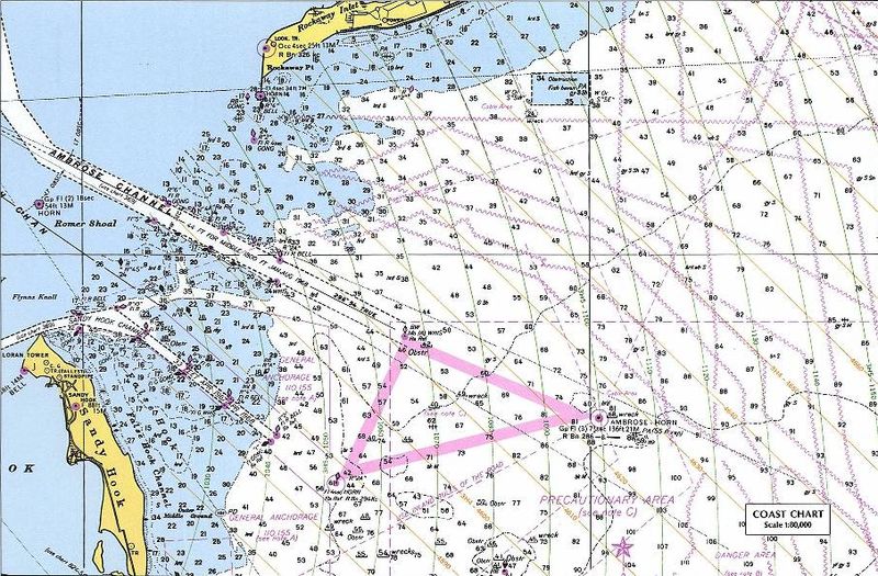
| Description |
Nautical chart including LORAN TD lines for ocean approaches to New York Harbor. The chart shows TD lines, apparently for LORAN-A, which would make it the Nantucket-Chatam-Montuck-Sandy Hook-Fenwick-Bodie Is-Cape Hatteras chain. Note that the printed TD lines do not extend into inland waterway areas, as LORAN propagates poorly over land. The green 1000 lines curve heavily in this area. Note the "LORAN TR" mark at the tip of Sandy Hook near the focus of the curves. This would be Station "J" (3H5). The ochre 4000 lines (3H4) would correspond to the TD between the master and Station "H" at Cape Hatteras. The master station of this chain was at Sankaty Head on Nantucket, Massachussets. [1] The sharp angle between these sets of TD rings, especially to the east and north, would make it a poor pair for precise navigation. This is a detail of the original at:
|
| Date | 18 December 2004 (original upload date) |
| Source |
Perry-Castañeda Map Collection, University of Texas at Austin - Original URL (detail) - Copyright statement Originally uploaded on en.wikipedia; the description page was written by User:KeithTyler, and imported from here. |
| Author | Unknown author |
| Permission (Reusing this file) |
PD-LAYOUT; PD-USGOV. |
![[2]](http://www.lib.utexas.edu/maps/national_atlas_1970/ca000219.jpg)
Licensing
[edit]
This work is in the public domain in the United States because it is a work prepared by an officer or employee of the United States Government as part of that person’s official duties under the terms of Title 17, Chapter 1, Section 105 of the US Code.
Note: This only applies to original works of the Federal Government and not to the work of any individual U.S. state, territory, commonwealth, county, municipality, or any other subdivision. This template also does not apply to postage stamp designs published by the United States Postal Service since 1978. (See § 313.6(C)(1) of Compendium of U.S. Copyright Office Practices). It also does not apply to certain US coins; see The US Mint Terms of Use.
|
 | |
| This file has been identified as being free of known restrictions under copyright law, including all related and neighboring rights. | ||
File history
Click on a date/time to view the file as it appeared at that time.
| Date/Time | Thumbnail | Dimensions | User | Comment | |
|---|---|---|---|---|---|
| current | 10:12, 14 July 2007 | | 906 × 595 (172 KB) | Massimiliano Lincetto (talk | contribs) | {{Information |Description=Nautical chart including en:LORAN TD lines for ocean approaches to New York Harbor. The chart shows TD lines, apparently for LORAN-A, which would make it the NANTUCKET-CHATHAM-MONTUCK-SANDY HOOK-FENWICK-BODIE IS-CAPE HATTE |
You cannot overwrite this file.
File usage on Commons
There are no pages that use this file.
File usage on other wikis
The following other wikis use this file:
- Usage on en.wikipedia.org
- Usage on fr.wikipedia.org
- Usage on it.wikipedia.org
- Usage on lv.wikipedia.org
- Usage on nl.wikipedia.org
- Usage on ru.wikipedia.org
- Usage on sl.wikipedia.org
- Usage on vi.wikipedia.org