File:Ngari map.svg
跳至導覽
跳至搜尋

此 SVG 檔案的 PNG 預覽的大小:800 × 557 像素。 其他解析度:320 × 223 像素 | 640 × 446 像素 | 1,024 × 713 像素 | 1,280 × 892 像素 | 2,560 × 1,784 像素 | 1,520 × 1,059 像素。
原始檔案 (SVG 檔案,表面大小:1,520 × 1,059 像素,檔案大小:189 KB)
說明
說明
添加單行說明來描述出檔案所代表的內容
摘要[編輯]
| 描述 |
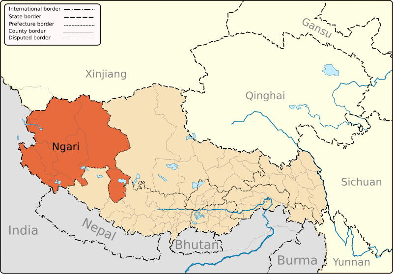
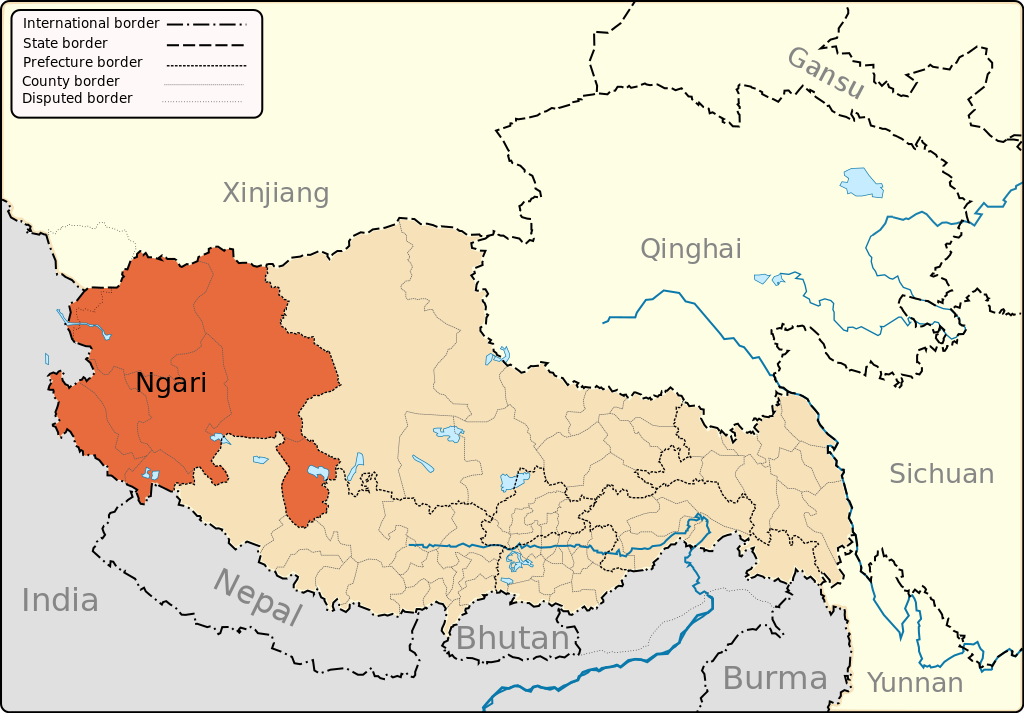
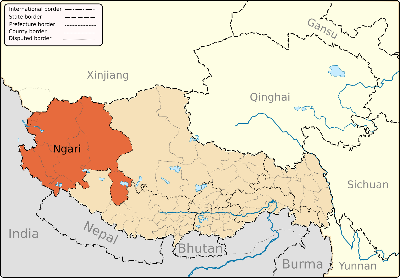
English: A map of the administrative boundaries of The Tibet Autonomous Region with Ngari (aka Ali) Prefecture highlighted. |
| 日期 | |
| 來源 | 自己的作品 |
| 作者 | Keithonearth |
| 其他版本 |
|
| SVG開發 |


授權條款[編輯]
我,本作品的著作權持有者,決定用以下授權條款發佈本作品:
此檔案採用共享創意 姓名標示-相同方式分享 3.0 未在地化版本授權條款。
- 您可以自由:
- 分享 – 複製、發佈和傳播本作品
- 重新修改 – 創作演繹作品
- 惟需遵照下列條件:
- 姓名標示 – 您必須指名出正確的製作者,和提供授權條款的連結,以及表示是否有對內容上做出變更。您可以用任何合理的方式來行動,但不得以任何方式表明授權條款是對您許可或是由您所使用。
- 相同方式分享 – 如果您利用本素材進行再混合、轉換或創作,您必須基於如同原先的相同或兼容的條款,來分布您的貢獻成品。

|
已授權您依據自由軟體基金會發行的無固定段落、封面文字和封底文字GNU自由文件授權條款1.2版或任意後續版本,對本檔進行複製、傳播和/或修改。該協議的副本列在GNU自由文件授權條款中。 |
您可以選擇您需要的授權條款。
檔案歷史
點選日期/時間以檢視該時間的檔案版本。
| 日期/時間 | 縮圖 | 尺寸 | 用戶 | 備註 | |
|---|---|---|---|---|---|
| 目前 | 2013年3月12日 (二) 20:14 | | 1,520 × 1,059(189 KB) | Keithonearth(對話 | 貢獻) | fixing Ngari/Shigatse prefecture boundary as pointed out by user:Fhah4 [http://en.wikipedia.org/w/index.php?title=Wikipedia:Graphics_Lab/Map_workshop&diff=541288793&oldid=541266575 here] |
| 2008年12月31日 (三) 05:04 |  | 1,520 × 1,059(212 KB) | Keithonearth(對話 | 貢獻) | Changing colour scheme to make more sense, progression from non-highlighted to most highlighted. Category:Tibet | |
| 2008年12月30日 (二) 02:17 |  | 1,520 × 1,059(212 KB) | Keithonearth(對話 | 貢獻) | {{Information |Description={{en|1=A map of the administrative boundaries of The Tibetan Autonomous Region with Nari (aka Ali) Prefecture highlighted.}} |Source=Own work by uploader |Author=Keithonearth |Date=2008-12-29 |Permission= | |
無法覆蓋此檔案。
檔案用途
下列10個頁面有用到此檔案:
全域檔案使用狀況
以下其他 wiki 使用了這個檔案:
- bn.wikipedia.org 的使用狀況
- bo.wikipedia.org 的使用狀況
- cdo.wikipedia.org 的使用狀況
- da.wikipedia.org 的使用狀況
- en.wikipedia.org 的使用狀況
- Ngari Prefecture
- Shiquanhe
- Rutog County
- Purang County
- Lumajangdong Co
- Template:Ngari Prefecture
- Coqên County
- Gar County
- Gê'gyai County
- Gertse County
- Zanda County
- Purang Town
- Coqên Town
- Rutog Town
- Demchok, Ngari Prefecture
- Tholing
- Minsar
- Zoco, Tibet
- Tsaparang
- Tholing Monastery
- Ngari Gunsa Airport
- Tegla Kar
- Orba Co
- Zhari Namco
- Dawa Lake
- Bangda Lake
- Guozha Lake
- Longmu Lake
- Chepzi
- Risum Township
- Tong Tso
- Wikipedia:Graphics Lab/Map workshop/Archive/Mar 2013
- Jaggang
- Tsosib Sumkyil Township
- es.wikipedia.org 的使用狀況
- eu.wikipedia.org 的使用狀況
- fa.wikipedia.org 的使用狀況
- fi.wikipedia.org 的使用狀況
- fr.wikipedia.org 的使用狀況
- hi.wikipedia.org 的使用狀況
- it.wikipedia.org 的使用狀況
- it.wikivoyage.org 的使用狀況
- pnb.wikipedia.org 的使用狀況
- pt.wikipedia.org 的使用狀況
- ru.wikipedia.org 的使用狀況
- sv.wikipedia.org 的使用狀況
檢視此檔案的更多全域使用狀況。