File:Niederösterreich Parteien 2018.svg
Jump to navigation
Jump to search

Size of this PNG preview of this SVG file: 800 × 549 pixels. Other resolutions: 320 × 220 pixels | 640 × 439 pixels | 1,024 × 703 pixels | 1,280 × 879 pixels | 2,560 × 1,758 pixels | 935 × 642 pixels.
Original file (SVG file, nominally 935 × 642 pixels, file size: 1.92 MB)
Captions
Captions
Add a one-line explanation of what this file represents
Summary
[edit]
| Description |
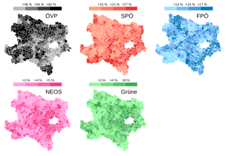
Deutsch: Ergebnis der Landtagswahl in Niederösterreich 2018 nach Gemeinden und Parteien. |
| Date | |
| Source |
Hochrechnung und Landtagswahl NÖ: Ergebnis auf Gemeindeebene, Gemeindedaten ohne Berücksichtigung der Wahlkarten., derStandard.at, 28. Jänner 2018
|
| Author | Furfur |
| Permission (Reusing this file) |
I, the copyright holder of this work, hereby publish it under the following license: This file is licensed under the Creative Commons Attribution-Share Alike 4.0 International license.
|
| SVG development |
File history
Click on a date/time to view the file as it appeared at that time.
| Date/Time | Thumbnail | Dimensions | User | Comment | |
|---|---|---|---|---|---|
| current | 18:35, 20 March 2018 | | 935 × 642 (1.92 MB) | Furfur (talk | contribs) | == {{int:filedesc}} == {{Information |description={{de|1=Ergebnis der Landtagswahl in Niederösterreich 2018 nach Gemeinden und Parteien.}} |date=2018-03-20 |source=[https://derstandard.at/2000073084482/Landtagswahl-Niederoesterreich-Hochrechnungen-und-Ergebnisse Hochrechnung und Landtagswahl NÖ: Ergebnis auf Gemeindeebene, Gemeindedaten ohne Berücksichtigung der Wahlkarten.], derStandard.at, 28. Jänner 2018 * Karten von Statistik Austria |author={{U|Furfur}} |permission={{self|cc-by-sa-4.0}} |other fields={{Igen|A|+|%v|s=m}} }} Category:SVG maps of Lower Austria Category:Election maps of Lower Austria |
You cannot overwrite this file.
File usage on Commons
The following page uses this file:
File usage on other wikis
The following other wikis use this file:
- Usage on de.wikipedia.org