File:Niederbauen-Pano.jpg
Jump to navigation
Jump to search

Size of this preview: 799 × 85 pixels. Other resolutions: 320 × 34 pixels | 640 × 68 pixels | 1,024 × 109 pixels | 1,280 × 136 pixels | 10,000 × 1,064 pixels.
Original file (10,000 × 1,064 pixels, file size: 3.62 MB, MIME type: image/jpeg)
Captions
Captions
Add a one-line explanation of what this file represents
Summary[edit]
| Description |
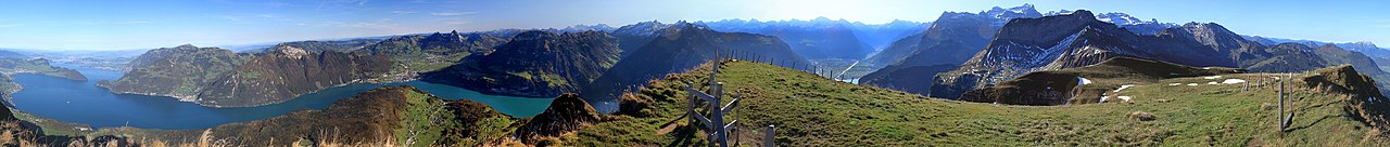
Deutsch: Panorama auf Niederbauen Kulm von Nordwest bis Südwest. |
| Date | Taken on 18 October 2011, 10:45:25 |
| Source | Panoramio 60793074 |
| Author | Iwan Schrackmann |
| Permission (Reusing this file) |
E-Mail vom 30. April 2022 an FkMohr. |
| Camera location | | View this and other nearby images on: OpenStreetMap |
|---|
Licensing[edit]
Iwan Schrackmann, the copyright holder of this work, hereby publishes it under the following license:
This file is licensed under the Creative Commons Attribution-Share Alike 3.0 Switzerland license.
Attribution: Iwan Schrackmann
- You are free:
- to share – to copy, distribute and transmit the work
- to remix – to adapt the work
- Under the following conditions:
- attribution – You must give appropriate credit, provide a link to the license, and indicate if changes were made. You may do so in any reasonable manner, but not in any way that suggests the licensor endorses you or your use.
- share alike – If you remix, transform, or build upon the material, you must distribute your contributions under the same or compatible license as the original.

File history
Click on a date/time to view the file as it appeared at that time.
| Date/Time | Thumbnail | Dimensions | User | Comment | |
|---|---|---|---|---|---|
| current | 11:35, 2 May 2022 | 10,000 × 1,064 (3.62 MB) | FkMohr (talk | contribs) | Uploaded a work by Iwan Schrackmann from Panoramio 60793074 with UploadWizard |
You cannot overwrite this file.
File usage on Commons
There are no pages that use this file.
File usage on other wikis
The following other wikis use this file:
- Usage on de.wikipedia.org