File:Niger, Settoré (1).jpg
Jump to navigation
Jump to search

Size of this preview: 800 × 450 pixels. Other resolutions: 320 × 180 pixels | 640 × 360 pixels | 1,024 × 576 pixels | 1,280 × 720 pixels | 2,560 × 1,440 pixels | 3,999 × 2,249 pixels.
Original file (3,999 × 2,249 pixels, file size: 2.63 MB, MIME type: image/jpeg)
Captions
Captions
Add a one-line explanation of what this file represents
Summary
[edit].jpg&action=edit§ion=1)
| Description |
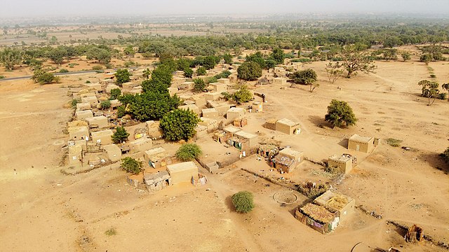
English: View of Settoré, a village in Niger along the Route Nationale 4 (RN No.4), some 15 km to the Northwest of Niamey on the right bank of the river Niger (Tillaberi region, Kollo department, Bitinkodji commune). The "Dunes of Niamey"-area is near the village.
Français : Vue de Settoré, village du Niger situé le long de la Route Nationale 4 (RN n°4), à environ 15 km au nord-ouest de Niamey sur la rive droite du fleuve Niger (région de Tillaberi, département de Kollo, commune de Bitinkodji). La zone "Dunes de Niamey" est proche du village. |
| Date | |
| Source | Own work |
| Author | Vincent van Zeijst |
Looking to the Northeast from here:
| Camera location | | View this and other nearby images on: OpenStreetMap |
|---|
.jpg¶ms=013.559717_N_0001.982525_E_globe:Earth_type:camera__&language=en)
Licensing
[edit].jpg&action=edit§ion=2)
I, the copyright holder of this work, hereby publish it under the following licenses:
This file is licensed under the Creative Commons Attribution-Share Alike 4.0 International license.
- You are free:
- to share – to copy, distribute and transmit the work
- to remix – to adapt the work
- Under the following conditions:
- attribution – You must give appropriate credit, provide a link to the license, and indicate if changes were made. You may do so in any reasonable manner, but not in any way that suggests the licensor endorses you or your use.
- share alike – If you remix, transform, or build upon the material, you must distribute your contributions under the same or compatible license as the original.

|
Permission is granted to copy, distribute and/or modify this document under the terms of the GNU Free Documentation License, Version 1.2 or any later version published by the Free Software Foundation; with no Invariant Sections, no Front-Cover Texts, and no Back-Cover Texts. A copy of the license is included in the section entitled GNU Free Documentation License. |
You may select the license of your choice.
Licensing
[edit].jpg&action=edit§ion=3)
I, the copyright holder of this work, hereby publish it under the following licenses:
|
|
Permission is granted to copy, distribute and/or modify this document under the terms of the GNU Free Documentation License, Version 1.2 or any later version published by the Free Software Foundation; with no Invariant Sections, no Front-Cover Texts, and no Back-Cover Texts. A copy of the license is included in the section entitled GNU Free Documentation License. |
This file is licensed under the Creative Commons Attribution-Share Alike 4.0 International license.
- You are free:
- to share – to copy, distribute and transmit the work
- to remix – to adapt the work
- Under the following conditions:
- attribution – You must give appropriate credit, provide a link to the license, and indicate if changes were made. You may do so in any reasonable manner, but not in any way that suggests the licensor endorses you or your use.
- share alike – If you remix, transform, or build upon the material, you must distribute your contributions under the same or compatible license as the original.
You may select the license of your choice.
File history
Click on a date/time to view the file as it appeared at that time.
| Date/Time | Thumbnail | Dimensions | User | Comment | |
|---|---|---|---|---|---|
| current | 21:33, 2 March 2021 | | 3,999 × 2,249 (2.63 MB) | NigerTZai (talk | contribs) | == {{int:filedesc}} == {{Information |description ={{en|1=View of Settoré, a village in Niger along the Route Nationale 4 (RN No.4), some 15 km to the Northwest of Niamey on the right bank of the river Niger (Tillaberi region, Kollo department, Bitinkodji commune). The "Dunes of Niamey"-area is near the village.}} {{fr|1=Vue de Settoré, village du Niger situé le long de la Route Nationale 4 (RN n°4), à environ 15 km au nord-ouest de Niamey sur la rive droite du fleuve Niger (région de Tilla... |
You cannot overwrite this file.
File usage on Commons
There are no pages that use this file.
File usage on other wikis
The following other wikis use this file:
- Usage on de.wikipedia.org
.jpg&oldid=868351749)