File:Niger river map.svg
跳转到导航
跳转到搜索

此SVG文件的PNG预览的大小:800 × 503像素。 其他分辨率:320 × 201像素 | 640 × 402像素 | 1,024 × 644像素 | 1,280 × 805像素 | 2,560 × 1,610像素 | 900 × 566像素。
原始文件 (SVG文件,尺寸为900 × 566像素,文件大小:56 KB)
说明
说明
添加一行文字以描述该文件所表现的内容
| 描述 |
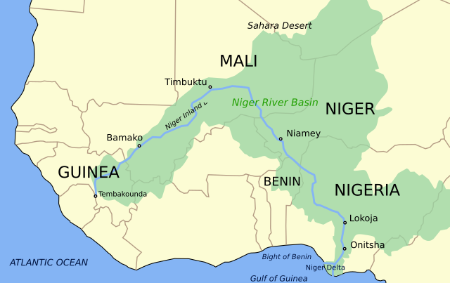
Català: Mapa del riu Níger i la seva conca English: Niger River map (basin included). Retraced into SVG. |
| 日期 | (UTC) |
| 来源 | |
| 作者 |
|
| 其他版本 |
[]
|


本文件采用知识共享署名-相同方式共享 3.0 未本地化版本许可协议授权。
- 您可以自由地:
- 共享 – 复制、发行并传播本作品
- 修改 – 改编作品
- 惟须遵守下列条件:
- 署名 – 您必须对作品进行署名,提供授权条款的链接,并说明是否对原始内容进行了更改。您可以用任何合理的方式来署名,但不得以任何方式表明许可人认可您或您的使用。
- 相同方式共享 – 如果您再混合、转换或者基于本作品进行创作,您必须以与原先许可协议相同或相兼容的许可协议分发您贡献的作品。
原始上传日志
[编辑]
This image is a derivative work of the following images:
- File:Niger_river_map.PNG licensed with Cc-by-sa-3.0-migrated, GFDL
- 2006-02-04T08:29:03Z Roke 900x566 (49542 Bytes) Map of the [[w:Niger River]], made by [[User:Astrokey44]] in Corel Painter IX from several sources. [[Category:Maps of Africa]]
Uploaded with derivativeFX
文件历史
点击某个日期/时间查看对应时刻的文件。
| 日期/时间 | 缩略图 | 大小 | 用户 | 备注 | |
|---|---|---|---|---|---|
| 当前 | 2023年9月16日 (六) 18:45 | | 900 × 566(56 KB) | Oihanguren(留言 | 贡献) | File uploaded using svgtranslate tool (https://svgtranslate.toolforge.org/). Added translation for eu. |
| 2023年9月15日 (五) 11:17 |  | 900 × 566(47 KB) | KajenCAT(留言 | 贡献) | File uploaded using svgtranslate tool (https://svgtranslate.toolforge.org/). Added translation for ca. | |
| 2010年1月20日 (三) 21:37 |  | 900 × 566(41 KB) | Wizardist(留言 | 贡献) | Smoothless desert label | |
| 2010年1月20日 (三) 21:33 |  | 900 × 566(34 KB) | Wizardist(留言 | 贡献) | {{Information |Description=Niger River map (basin included). Retraced into SVG. |Source=*File:Niger_river_map.PNG |Date=2010-01-20 21:32 (UTC) |Author=*author of File:Niger_river_map.PNG *derivative work: ~~~ |Permission=see below |other_versi |
您不可以覆盖此文件。
文件用途
以下12个页面使用本文件:
- User:Magog the Ogre/Multilingual legend/2023 September 11-15
- User:Magog the Ogre/Multilingual legend/2023 September 16-20
- File:Niger river map-es.svg
- File:Niger river map-uk.svg
- File:Niger river map.PNG
- File:Niger river map.svg
- File:Niger river map hr.svg
- File:Niger river map ka.svg
- File:Niger river map mk.svg
- Template:Other versions/Niger river map
- Category:Niger River
- Category:Tributaries of the Niger River
全域文件用途
以下其他wiki使用此文件:
- af.wikipedia.org上的用途
- ar.wikipedia.org上的用途
- arz.wikipedia.org上的用途
- ast.wikipedia.org上的用途
- be-tarask.wikipedia.org上的用途
- be.wikipedia.org上的用途
- ca.wikipedia.org上的用途
- de.wikipedia.org上的用途
- en.wikipedia.org上的用途
- Niger River
- Bamako
- Niamey
- Timbuktu
- Onitsha
- Bani River
- Mopti
- National Park of Upper Niger
- Gao
- Ségou
- Kaduna River
- Siguiri
- Lokoja
- Inner Niger Delta
- Tinkisso River
- Escravos River
- Forçados River
- Niger Delta
- Nun River
- Markala
- Kainji Lake
- Sokoto River
- Kouroussa
- Lake Débo
- Niger Basin Authority
- Azawagh
- Template:Niger River
- Sankarani River
- Mékrou River
- Tembakounda
- Kennedy Bridge (Niamey)
- King Fahd Bridge
- Martyrs Bridge (Bamako)
- List of tributaries of the Niger
- River Niger Bridge
- Sota River
- Anambra River
查看此文件的更多全域用途。