File:NigeriaNumbered.png
Jump to navigation
Jump to search

Size of this preview: 732 × 599 pixels. Other resolutions: 293 × 240 pixels | 586 × 480 pixels | 938 × 768 pixels | 1,250 × 1,024 pixels | 2,320 × 1,900 pixels.
Original file (2,320 × 1,900 pixels, file size: 509 KB, MIME type: image/png)
Captions
Captions
Add a one-line explanation of what this file represents
Summary
[edit]
| Description |
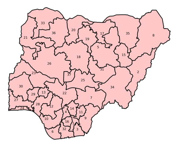
Numbered maps of the 36 en:States of Nigeria, in English (alphabetical) order with the Capital region as number 37. Drawn by en:User:Morwen. |
| Date | 20 July 2005 (original upload date) |
| Source | Transferred from en.wikipedia to Commons. |
| Author | The original uploader was Morwen at English Wikipedia. |
Licensing
[edit]

|
Permission is granted to copy, distribute and/or modify this document under the terms of the GNU Free Documentation License, Version 1.2 or any later version published by the Free Software Foundation; with no Invariant Sections, no Front-Cover Texts, and no Back-Cover Texts. A copy of the license is included in the section entitled GNU Free Documentation License. |
| This file is licensed under the Creative Commons Attribution-Share Alike 3.0 Unported license. | ||
| ||
| This licensing tag was added to this file as part of the GFDL licensing update. |
Original upload log
[edit]
The original description page was here. All following user names refer to en.wikipedia.
File history
Click on a date/time to view the file as it appeared at that time.
| Date/Time | Thumbnail | Dimensions | User | Comment | |
|---|---|---|---|---|---|
| current | 00:19, 7 June 2023 | | 2,320 × 1,900 (509 KB) | BlueSahelian (talk | contribs) | Black lines to look closer to original |
| 00:15, 7 June 2023 |  | 2,499 × 1,971 (514 KB) | BlueSahelian (talk | contribs) | Higher resolution | |
| 12:54, 8 August 2005 |  | 400 × 355 (70 KB) | Qurqa~commonswiki (talk | contribs) | Numbered maps of the 36 States of Nigeria, in English (alphabetical) order with the Capital region as number 37. Drawn by User:Morwen. {{GFDL}} |
You cannot overwrite this file.
File usage
The following page uses this file:
Global file usage
The following other wikis use this file:
- Usage on ar.wikipedia.org
- Usage on ast.wikipedia.org
- Usage on bg.wikipedia.org
- Usage on cs.wikipedia.org
- Usage on da.wikipedia.org
- Usage on de.wikipedia.org
- Usage on en.wikipedia.org
- States of Nigeria
- National Assembly (Nigeria)
- List of Nigerian states by population
- List of Nigerian states by area
- List of current state governors in Nigeria
- List of nicknames of Nigerian states
- List of Nigerian states by date of statehood
- House of Representatives (Nigeria)
- Template:NigerianStateLists
- List of Nigerian states by GDP
- List of Nigerian states by highest point
- List of Nigerian states by Human Development Index
- List of Nigerian states by literacy rate
- Voting rights in Nigeria
- List of Nigerian states by poverty rate
- Usage on eo.wikipedia.org
- Usage on es.wikipedia.org
- Usage on fi.wikipedia.org
- Usage on gl.wikipedia.org
- Usage on ha.wikipedia.org
- Usage on he.wikipedia.org
- Usage on hu.wikipedia.org
- Usage on igl.wikipedia.org
- Usage on ig.wikipedia.org
- Usage on incubator.wikimedia.org
- Usage on it.wikipedia.org
- Usage on ja.wikipedia.org
- Usage on lt.wikipedia.org
- Usage on nl.wikipedia.org
- Usage on pl.wikipedia.org
- Usage on pt.wikipedia.org
View more global usage of this file.