File:Nishioizumi-machi, CKT20176-C29-3.png
Jump to navigation
Jump to search

Size of this preview: 660 × 599 pixels. Other resolutions: 264 × 240 pixels | 529 × 480 pixels | 846 × 768 pixels | 1,087 × 987 pixels.
Original file (1,087 × 987 pixels, file size: 1.69 MB, MIME type: image/png)
Captions
Captions
Add a one-line explanation of what this file represents
Summary[edit]
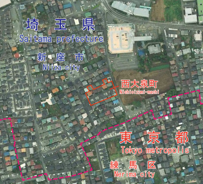
| Description |
日本語: 東京都練馬区西大泉町付近の空中写真。都県境はGoogle Mapを参照して引いたものであり、正確な境界線を必要とする場合は、公図を参照してください。
English: An aerial photo of Nishioizumi-machi, Nerima, Tokyo, Japan. I drew the boundary of Saitama pref. and Tokyo metro. by data of google map. If you need more accurate boundary line, please refer to a public map. |
| Date | Taken on 23 August 2017 |
| Source |
日本語: 国土画像情報(カラー空中写真)(整理番号:CKT20176、コース番号:C29、写真番号:3、撮影年月日:2017年8月23日、撮影地域:東京、撮影高度:2197m、数値写真レベル:10000、カメラ名称:DMC2e-230、焦点距離:92.020mm、カラー種別:カラー、写真種別:デジタル、撮影計画機関:国土地理院、市区町村名:練馬区)https://mapps.gsi.go.jp/contentsImageDisplay.do?specificationId=1821347&isDetail=true
English: National Land Image Information (Color Aerial Photographs) (Reference number: CKT20176; Course Number: C29; Photo Number: 3; Date: August 23, 2017; Area: Tokyo; Height: 2197 metre; Numeric Photo Level: 10000; Camera Name: DMC2e-230; Focal distance: 92.020 millimetre; Color Type: Color; Photo Type: Digital; Agency: Geographical Survey Institute of Japan; Municipality: Nerima City) https://mapps.gsi.go.jp/contentsImageDisplay.do?specificationId=1821347&isDetail=true |
| Author |
English: Geographical Survey Institute of Japan 日本語: 国土地理院 |
Licensing[edit]

|
The copyright holder of this file, Ministry of Land, Infrastructure, Transport and Tourism, allows anyone to use it for any purpose, provided that the copyright holder is properly attributed. Redistribution, derivative work, commercial use, and all other use is permitted. |
Attribution:
National Land Image Information (Color Aerial Photographs), created by Ministry of Land, Infrastructure, Transport and Tourism, distributed by Geospatial Information Authority of Japan
|

File history
Click on a date/time to view the file as it appeared at that time.
| Date/Time | Thumbnail | Dimensions | User | Comment | |
|---|---|---|---|---|---|
| current | 13:29, 5 June 2021 | | 1,087 × 987 (1.69 MB) | Miyuki Meinaka (talk | contribs) | Uploaded a work by {{en|1=Geographical Survey Institute of Japan}}{{ja|1=国土地理院}} from {{ja|1=国土画像情報(カラー空中写真)(整理番号:CKT20176、コース番号:C29、写真番号:3、撮影年月日:2017年8月23日、撮影地域:東京、撮影高度:2197m、数値写真レベル:10000、カメラ名称:DMC2e-230、焦点距離:92.020mm、カラー種別:カラー、写真種別:デジタル、撮影計画機関:国土地理院、市区町村名:練馬区)https://mapps.gsi.go.jp/contentsImageDisplay.do?specificationId=1821347&isDetail=true}} {{en|1=National Land Image Information (Color Aerial Photographs) (Reference number: CKT20176; Course Number: C29; Photo Number: 3; Date: August 2... |
You cannot overwrite this file.
File usage on Commons
There are no pages that use this file.
File usage on other wikis
The following other wikis use this file:
- Usage on en.wikipedia.org
- Usage on ja.wikipedia.org
- Usage on th.wikipedia.org
- Usage on zh.wikipedia.org