File:North-Sea-Labels-3.jpg

Original file (1,220 × 1,678 pixels, file size: 2.12 MB, MIME type: image/jpeg)
Captions
Captions
Summary[edit]
| Description |
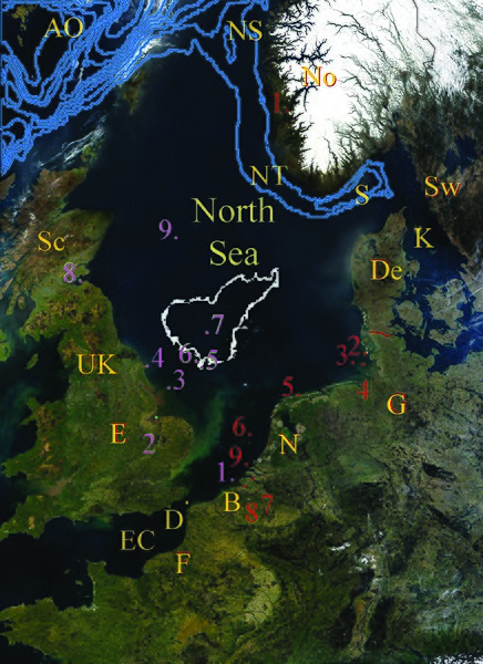
English: North Sea Map derived from NASA satellite image.
These bathymetric or topographic locations are areas. Only the Dogger Bank and Norwegian Trench show their area due to their size. They center where the dots are located by the number, and are smaller in size. The other areas which are somewhat large in size are the Broad Fourteens and Outer Silver Pit. The Outer Silver Pit is a pit by the south west edge of the Dogger Bank. The Broad Fourteens extend across the southern portion of the North Sea from approximately the area of the Inner Silver Pit and across to the red 6 following the geological terrain. Red
Purple
Yellow (These countries and neighbouring waters have no dots except for the Strait of Dover which does - as it is so tiny in comparison to the other geographic areas, and lettering would not fit in the space.)
|
| Date | |
| Source | Derivitive work from File:NASA NorthSea1 2.jpg |
| Author | SriMesh |
| Other versions |
Geography of the North Sea will have the coordinates of all points above. For the Dogger Bank location see The Dogger Bank - A Potential MPA [https://books.google.ca/books?id=BsPWhZrsYHoC&pg=PA185&lpg=PA185&dq=map+dogger+bank+location&source=web&ots=-LPOj8N5LI&sig=qhq-OZCm5Q7-4tZWDw7PJzYMB-U&hl=en&sa=X&oi=book_result&resnum=9&ct=result Guide to the Oceans By John Pernetta page 185] |
Licensing[edit]
- You are free:
- to share – to copy, distribute and transmit the work
- to remix – to adapt the work
- Under the following conditions:
- attribution – You must give appropriate credit, provide a link to the license, and indicate if changes were made. You may do so in any reasonable manner, but not in any way that suggests the licensor endorses you or your use.
- share alike – If you remix, transform, or build upon the material, you must distribute your contributions under the same or compatible license as the original.

|
Permission is granted to copy, distribute and/or modify this document under the terms of the GNU Free Documentation License, Version 1.2 or any later version published by the Free Software Foundation; with no Invariant Sections, no Front-Cover Texts, and no Back-Cover Texts. A copy of the license is included in the section entitled GNU Free Documentation License. |
File history
Click on a date/time to view the file as it appeared at that time.
| Date/Time | Thumbnail | Dimensions | User | Comment | |
|---|---|---|---|---|---|
| current | 20:28, 22 January 2009 | | 1,220 × 1,678 (2.12 MB) | SriMesh (talk | contribs) | {{Information |Description= |Source= |Date= |Author= |Permission= |other_versions= }} |
| 20:19, 22 January 2009 |  | 1,220 × 1,678 (2.12 MB) | SriMesh (talk | contribs) | {{Information |Description= |Source= |Date= |Author= |Permission= |other_versions= }} | |
| 20:13, 22 January 2009 |  | 1,220 × 1,678 (2.12 MB) | SriMesh (talk | contribs) | {{Information |Description= |Source= |Date= |Author= |Permission= |other_versions= }} | |
| 20:04, 22 January 2009 |  | 1,300 × 1,700 (1.64 MB) | SriMesh (talk | contribs) | {{Information |Description={{en|1=|Description={{en|1=North Sea Map Red *1. Hardanger Fjord *2. Wadden Sea *3. German Bight *4. Helgoland Bight *5. Frisian Islands *6. Broad Fourteens *7. Oosterchlede *8. Helgoland Bight *9. Zeeland Banks Purple * |
You cannot overwrite this file.
File usage on Commons
There are no pages that use this file.
File usage on other wikis
The following other wikis use this file:
- Usage on en.wikipedia.org