File:North America from low orbiting satellite Suomi NPP.jpg
跳转到导航
跳转到搜索

本预览的尺寸:600 × 600像素。 其他分辨率:240 × 240像素 | 480 × 480像素 | 768 × 768像素 | 1,024 × 1,024像素 | 2,048 × 2,048像素 | 8,000 × 8,000像素。
原始文件 (8,000 × 8,000像素,文件大小:16.43 MB,MIME类型:image/jpeg)
说明
说明
添加一行文字以描述该文件所表现的内容
摘要
[编辑]| 警告 | 部分浏览器在浏览此图片的完整大小时可能会遇到困难:该图片中有数量巨大的像素点,可能无法完全载入或者导致您的浏览器停止响应。 |
|---|
| 描述 |
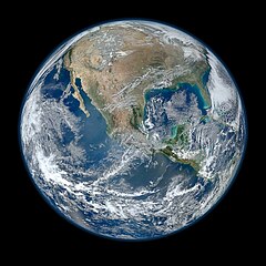
English: A view of most of North America taken from a low orbit of about 826 km altitude. The whole hemisphere is not visible owing to the low orbit, and the horizon is at a distance of about 3,300 km, while the radius of the planet is 6,371 km. The diameter seen from this height is about 125 degrees.
An image of the Earth taken from the VIIRS instrument aboard NASA's Earth-observing research satellite, Suomi NPP. This composite image uses a number of swaths of the Earth's surface taken on 4 January 2012. The NPP satellite was renamed 'Suomi NPP' on 24 January 2012 to honour the late Verner E. Suomi of the University of Wisconsin. Suomi NPP carries five instruments on board. The biggest and most important instrument is The Visible/Infrared Imager Radiometer Suite or VIIRS.
Español: Una vista de la mayor parte de América del Norte tomada desde una órbita baja. Esta vista resulta de una altura del satélite que está a unos 826 kilómetros por encima de la superficie de la Tierra. Debido a la órbita baja el hemisferio no es totalmente visible, y el horizonte se encuentra en una distancia de tan sólo aproximadamente 3300 km, mientras que el radio de nuestro planeta es 6371 kilómetros. El diámetro del horizonte visto desde esta altura es de aproximadamente 125 grados. |
||||
| 日期 | |||||
| 来源 |
http://www.nasa.gov/multimedia/imagegallery/image_feature_2159.html; SEE Also => http://solarsystem.nasa.gov/multimedia/display.cfm?IM_ID=9643 AND http://solarsystem.nasa.gov/planets/profile.cfm?Object=Earth |
||||
| 作者 | NASA/NOAA/GSFC/Suomi NPP/VIIRS/Norman Kuring | ||||
| 其他版本 |
|

.jpg)
|
本图像被选为2014年4月22日的今日图片。其说明如下: English: On Earth Day, a view of most of North America taken from a low orbit of about 826 km altitude aboard NASA's Earth-observing research satellite, Suomi NPP. 其他语言:
Bosanski: Fotografija načinjena na Dan planete Zemlje, pogled na veći dio Sjeverne Amerike iz niske orbite od oko 826 km iznad površine iz NASA-inog satelita za istraživanje Zemlje Suomi NPP. Čeština: Na dnešní den: Den Země, pohled na Severní Ameriku z nízké oběžné dráhy z výšky kolem 826 km, snímek z meteorologického satelitu Suomi NPP. English: On Earth Day, a view of most of North America taken from a low orbit of about 826 km altitude aboard NASA's Earth-observing research satellite, Suomi NPP. Italiano: L'America settentrionale fotografata in orbita bassa nella Giornata della Terra dal satellite di ricerca Suomi NPP. Magyar: A Föld napja: Észak-Amerika nagyobb részének képe, amely a NASA egyik alacsony pályán, mintegy 826 km magasságban keringő Föld-megfigyelő műholdjáról, a Suomi NPP-ről készült Nederlands: Op de Dag van de Aarde een blik op Noord-Amerika vanaf een lage baan op 826 kilometer hoogte vanuit de NASA-satelliet Suomi NPP. 中文: 世界地球日,美国宇航局的地球观测卫星在低轨道826公里处拍摄的北美洲大部分地区的照片。 |
许可协议
[编辑]
| 本文件完全由NASA创作,在美国属于公有领域。根据NASA的版权方针,NASA的材料除非另有声明否则不受版权保护。(参见Template:PD-USGov/zh、NASA版权方针页面或JPL图片使用方针。) | ||
 |
警告:
|
文件历史
点击某个日期/时间查看对应时刻的文件。
| 日期/时间 | 缩略图 | 大小 | 用户 | 备注 | |
|---|---|---|---|---|---|
| 当前 | 2012年1月26日 (四) 04:03 | | 8,000 × 8,000(16.43 MB) | Hellbus(留言 | 贡献) | {{Information |Description ={{en|1=A 'Blue Marble' image of the Earth taken from the VIIRS instrument aboard NASA's most recently launched Earth-observing satellite - Suomi NPP. This composite image uses a number of swaths of the Earth's surface taken |
您不可以覆盖此文件。
文件用途
以下46个页面使用本文件:
- Earth
- User:Hidayatsrf/Gallery
- User:May0721/Featured pictures in the public domain
- User:Miya/sandbox/FP/2013/Galleries/Table
- User:Nigreco451/FPGallery
- User:Northamerica1000
- User:Zyephyrus/2014
- User:Zyephyrus/2014/11
- User:Ö/Best/2013
- User talk:Mono/Archives/2013
- Commons:Featured picture candidates/File:Earth western hemisphere from Suomi NPP.jpg
- Commons:Featured picture candidates/File:North America from low orbiting satellite Suomi NPP.jpg
- Commons:Featured picture candidates/Log/February 2012
- Commons:Featured picture candidates/Log/November 2013
- Commons:Featured pictures/Astronomy
- Commons:Featured pictures/chronological/2013-B
- Commons:Picture of the Year/2013/Candidates
- Commons:Picture of the Year/2013/Galleries/Table
- Commons:Picture of the Year/2013/R1/Gallery/2013-B
- Commons:Picture of the Year/2013/R1/Gallery/ALL
- Commons:Picture of the Year/2013/R1/Gallery/Astronomy
- Commons:Picture of the Year/2013/R1/Gallery/M11
- Commons:Picture of the Year/2013/R1/Results/Candidates
- Commons:Picture of the Year/2013/R1/v/North America from low orbiting satellite Suomi NPP.jpg
- Commons:WikiProject Aviation/recent uploads/2012 January 21-31
- Commons talk:Picture of the Year/2013/R1/Results/Candidates
- File:Earth - Then and Now Courtesy of NASA (8281707679).jpg
- File:Earth western hemisphere from Suomi NPP.jpg(文件重定向)
- File:Image-instruments-Earth-satellite-NASA-Suomi-National-2012.webp(文件重定向)
- File:La tierra vista desde el espacio.jpg(文件重定向)
- File:Mars Earth Comparison 2.jpg
- File:Most Amazing High Definition Image of Earth - Blue Marble 2012 (6760135001).jpg(文件重定向)
- File:PIA18033-Earth-TrueColor-20120104.jpg(文件重定向)
- Template:Potd/2014-04
- Template:Potd/2014-04-22
- Template:Potd/2014-04-22 (bs)
- Template:Potd/2014-04-22 (cs)
- Template:Potd/2014-04-22 (en)
- Template:Potd/2014-04-22 (hu)
- Template:Potd/2014-04-22 (it)
- Template:Potd/2014-04-22 (nl)
- Template:Potd/2014-04-22 (zh-hans)
- Template:Potd/2014-04 (zh-hans)
.jpg&redirect=no)
全域文件用途
以下其他wiki使用此文件:
- af.wikipedia.org上的用途
- ar.wikipedia.org上的用途
- as.wikipedia.org上的用途
- az.wikiquote.org上的用途
- be-tarask.wikipedia.org上的用途
- bn.wikipedia.org上的用途
- crh.wikipedia.org上的用途
- cv.wikipedia.org上的用途
- de.wikipedia.org上的用途
- el.wikipedia.org上的用途
- en.wikipedia.org上的用途
- The Blue Marble
- Portal:Energy
- Portal:Energy/Energy topics
- User:Northamerica1000
- Portal:Society/Featured article
- User talk:Semccraw
- User talk:Jesusserrano
- User talk:Bmbrooks
- User talk:Bhaluska
- User talk:Ependell
- User talk:Mmutterperl
- User talk:Kaylaek
- User talk:Tjohns17
- User talk:BellaBeast
- User talk:JessicaSG
- User talk:Laurenm2
- User talk:Jessgutman
- User talk:Lissyh1990
- User talk:Maxsasaki
- User talk:Aebarone
- User talk:Emackin
- User talk:Lmfye
- User talk:EauroraUA
- User talk:Jaallen1
- User talk:Dkunst
- User talk:Girg45
- User talk:Cindyy1
- User talk:Aglick
- Suomi NPP
- User:Cullen328/Welcome
- Wikipedia:Featured picture candidates/February-2012
- User talk:Sdmuszyn
- User talk:Allieglock
- User talk:Cpatel623
- User talk:Darrinbrink
查看此文件的更多全域用途。