File:North East England counties 2009 map.svg
Aller à la navigation
Aller à la recherche

Taille de cet aperçu PNG pour ce fichier SVG : 482 × 599 pixels. Autres résolutions : 193 × 240 pixels | 386 × 480 pixels | 618 × 768 pixels | 824 × 1 024 pixels | 1 647 × 2 048 pixels | 1 082 × 1 345 pixels.
Fichier d’origine (Fichier SVG, nominalement de 1 082 × 1 345 pixels, taille : 723 kio)
Légendes
Légendes
Ajoutez en une ligne la description de ce que représente ce fichier
Description[modifier]
| Description |
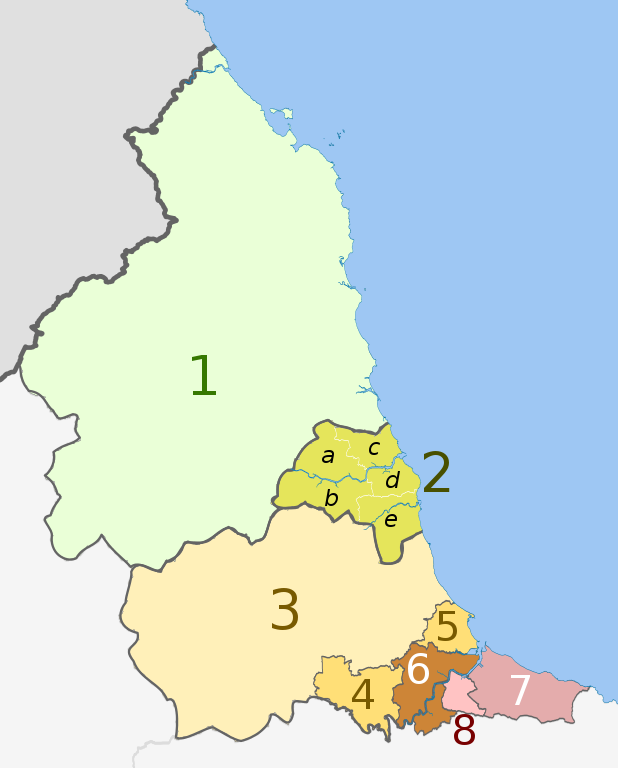
English: Map of the North East England region of England, showing its counties and administrative districts. The county colours are the same as those in File:English metropolitan and non-metropolitan counties 2009.svg.
Equirectangular map projection on WGS 84 datum, with N/S stretched 170% Geographic limits:
|
| Date | (UTC) |
| Source |
Ce fichier est dérivé de : |
| Auteur |
|
| Autres versions |
 |


| Map | Ceremonial county | Unitary authority | Metropolitan districts |
|---|---|---|---|
 |
1. Northumberland | ||
| 2. Tyne and Wear metropolitan county |
a) Newcastle upon Tyne, b) Gateshead, c) North Tyneside, d) South Tyneside, e) Sunderland | ||
| Durham | 3. Durham | ||
| 4. Darlington | |||
| 5. Hartlepool | |||
| 6. Stockton-on-Tees | |||
| North Yorkshire (part only) | |||
| 7. Redcar and Cleveland | |||
| 8. Middlesbrough | |||
Conditions d’utilisation[modifier]
Ce fichier est disponible selon les termes de la licence Creative Commons Attribution – Partage dans les Mêmes Conditions 3.0 (non transposée).
Attribution: Dr Greg and Nilfanion. Contains Ordnance Survey data © Crown copyright and database right 2011
- Vous êtes libre :
- de partager – de copier, distribuer et transmettre cette œuvre
- d’adapter – de modifier cette œuvre
- Sous les conditions suivantes :
- paternité – Vous devez donner les informations appropriées concernant l'auteur, fournir un lien vers la licence et indiquer si des modifications ont été faites. Vous pouvez faire cela par tout moyen raisonnable, mais en aucune façon suggérant que l’auteur vous soutient ou approuve l’utilisation que vous en faites.
- partage à l’identique – Si vous modifiez, transformez, ou vous basez sur cette œuvre, vous devez distribuer votre contribution sous la même licence ou une licence compatible avec celle de l’original.
Journal des téléversements d’origine[modifier]
This image is a derivative work of the following images:
- File:North_East_England__districts_2011_map.svg licensed with Cc-by-sa-3.0, GFDL
- 2011-05-01T18:56:43Z Nilfanion 1082x1345 (714062 Bytes) == Summary == {{Information |Description=Map of the [[w:North East England|North East England]] region showing the administrative districts. Equirectangular map projection on WGS 84 datum, with N/S stretched 170% Geographic
- File:English_ceremonial_counties_2010.svg licensed with Cc-by-sa-3.0, GFDL
- 2010-11-23T16:39:55Z Nilfanion 1108x1345 (308868 Bytes) thicker lines
- 2010-11-23T16:20:19Z Nilfanion 1108x1345 (301520 Bytes) tweaks
- 2010-10-26T20:34:20Z Nilfanion 817x990 (1391832 Bytes) {{Information |Description=Map showing the [[w:ceremonial counties of England]] including the City of London, in 2010. Equirectangular map projection on WGS 84 datum, with N/S stretched 170% Geographic limits: *West: 6.75W
Téléversé avec derivativeFX
Historique du fichier
Cliquer sur une date et heure pour voir le fichier tel qu'il était à ce moment-là.
| Date et heure | Vignette | Dimensions | Utilisateur | Commentaire | |
|---|---|---|---|---|---|
| actuel | 14 août 2018 à 20:16 | | 1 082 × 1 345 (723 kio) | Inops (d | contributions) | change letters labelling the boroughs of Tyne and Wearfrom white to black. Hardly intelligible when thumbnailed otherwise |
| 5 mai 2012 à 20:11 |  | 1 082 × 1 345 (723 kio) | Dr Greg (d | contributions) | lighten black boundary line | |
| 1 mai 2012 à 22:21 |  | 1 082 × 1 345 (723 kio) | Dr Greg (d | contributions) | == {{int:filedesc}} == {{Information |Description={{en|Map of the North East England region of England, showing its counties and administrative districts. The county colours are the same as those in [[:File:English metropolitan... |
Vous ne pouvez pas remplacer ce fichier.
Utilisations locales du fichier
Les 3 pages suivantes utilisent ce fichier :
Utilisations du fichier sur d’autres wikis
Les autres wikis suivants utilisent ce fichier :
- Utilisation sur ar.wikipedia.org
- Utilisation sur ca.wikipedia.org
- Utilisation sur de.wikipedia.org
- Utilisation sur en.wikipedia.org
- Utilisation sur es.wikipedia.org
- Utilisation sur fa.wikipedia.org
- Utilisation sur fr.wikipedia.org
- Utilisation sur hu.wikipedia.org
- Utilisation sur ja.wikipedia.org
- Utilisation sur mr.wikipedia.org
- Utilisation sur pl.wikipedia.org
- Utilisation sur pnb.wikipedia.org
- Utilisation sur th.wikipedia.org
- Utilisation sur ur.wikipedia.org
- Utilisation sur vi.wikipedia.org
- Utilisation sur vls.wikipedia.org
- Utilisation sur zh-yue.wikipedia.org