File:North Island Line proposal swap zh hant.svg
跳至導覽
跳至搜尋

此 SVG 檔案的 PNG 預覽的大小:800 × 237 像素。 其他解析度:320 × 95 像素 | 640 × 189 像素 | 1,024 × 303 像素 | 1,280 × 379 像素 | 2,560 × 758 像素 | 1,250 × 370 像素。
原始檔案 (SVG 檔案,表面大小:1,250 × 370 像素,檔案大小:10 KB)
說明
說明
添加單行說明來描述出檔案所代表的內容
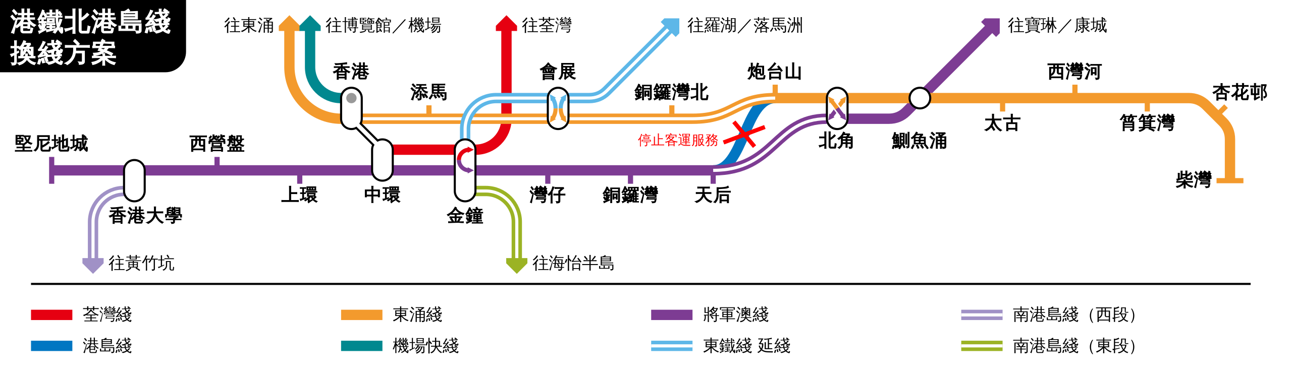
| 描述 | Hong Kong MTR proposed North Island Line original route scheme, now called the "swap" plan. In other words, this scheme divides Island Line into two sections for other two cross-harbor lines. | ||
| 日期 | |||
| 來源 | 自己的作品 | ||
| 作者 | Sameboat | ||
| 授權許可 (重用此檔案) |
|
||
| 其他版本 |
|
Please do not replace the simplified code of this file with a version created with Inkscape or any other vector graphics editor
檔案歷史
點選日期/時間以檢視該時間的檔案版本。
| 日期/時間 | 縮圖 | 尺寸 | 用戶 | 備註 | |
|---|---|---|---|---|---|
| 目前 | 2018年7月15日 (日) 15:04 | 1,250 × 370(10 KB) | Sameboat(對話 | 貢獻) | doctype and validate | |
| 2018年5月26日 (六) 00:04 | 1,250 × 370(10 KB) | Sameboat(對話 | 貢獻) | East Rail Line extension | ||
| 2015年1月24日 (六) 01:39 | 1,250 × 370(10 KB) | Sameboat(對話 | 貢獻) | |||
| 2014年12月29日 (一) 02:21 | 1,250 × 370(10 KB) | Sameboat(對話 | 貢獻) | WIL | ||
| 2014年9月19日 (五) 06:34 | 1,250 × 370(10 KB) | Sameboat(對話 | 貢獻) | minor | ||
| 2014年2月10日 (一) 15:08 | 1,250 × 370(10 KB) | Sameboat(對話 | 貢獻) | |||
| 2014年2月10日 (一) 01:19 | 1,250 × 370(10 KB) | Sameboat(對話 | 貢獻) | fix dimension | ||
| 2014年2月9日 (日) 09:47 | 1,110 × 330(10 KB) | Sameboat(對話 | 貢獻) | |||
| 2014年2月9日 (日) 07:03 | 1,110 × 330(10 KB) | Sameboat(對話 | 貢獻) | |||
| 2014年2月9日 (日) 06:58 | 1,110 × 330(10 KB) | Sameboat(對話 | 貢獻) |
無法覆蓋此檔案。
檔案用途
下列12個頁面有用到此檔案:
- MTR Hong Kong
- User:Chumwa/OgreBot/Potential transport maps/2018 July 11-20
- User:Chumwa/OgreBot/Potential transport maps/2018 May 21-31
- User:Chumwa/OgreBot/Public transport information/2018 July 11-20
- User:Chumwa/OgreBot/Public transport information/2018 May 21-31
- User:Chumwa/OgreBot/Transport Maps/2018 July 11-20
- User:Chumwa/OgreBot/Transport Maps/2018 May 21-31
- User:Chumwa/OgreBot/Travel and communication maps/2018 July 11-20
- User:Chumwa/OgreBot/Travel and communication maps/2018 May 21-31
- User:OgreBot/Watercraft/2018 July 15
- User:OgreBot/Watercraft/2018 May 26
- User:Sameboat