File:North Wales Roads & Sea.png
Jump to navigation
Jump to search

Size of this preview: 750 × 600 pixels. Other resolutions: 300 × 240 pixels | 600 × 480 pixels | 960 × 768 pixels | 1,280 × 1,024 pixels | 2,560 × 2,048 pixels | 3,300 × 2,640 pixels.
Original file (3,300 × 2,640 pixels, file size: 1.67 MB, MIME type: image/png)
Captions
Captions
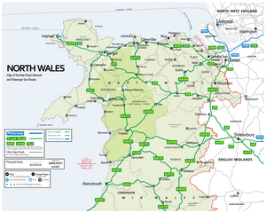
Map of the North Wales Road Network (and sea routes)
Summary[edit]
| Description |
English: Map depicting the Primary Roads and neighbouring Motorways of North Wales. E-routes, airports, ports and localities are also depicted. |
| Date | |
| Source | Own work |
| Author | Dank · Jay |
Licensing[edit]
I, the copyright holder of this work, hereby publish it under the following license:
This file is licensed under the Creative Commons Attribution-Share Alike 4.0 International license.
- You are free:
- to share – to copy, distribute and transmit the work
- to remix – to adapt the work
- Under the following conditions:
- attribution – You must give appropriate credit, provide a link to the license, and indicate if changes were made. You may do so in any reasonable manner, but not in any way that suggests the licensor endorses you or your use.
- share alike – If you remix, transform, or build upon the material, you must distribute your contributions under the same or compatible license as the original.
File history
Click on a date/time to view the file as it appeared at that time.
| Date/Time | Thumbnail | Dimensions | User | Comment | |
|---|---|---|---|---|---|
| current | 22:15, 15 December 2021 | | 3,300 × 2,640 (1.67 MB) | DankJae (talk | contribs) | higher resolution |
| 21:33, 21 September 2020 |  | 1,100 × 880 (458 KB) | DankJae (talk | contribs) | Uploaded own work with UploadWizard |
You cannot overwrite this file.
File usage on Commons
The following page uses this file:
File usage on other wikis
The following other wikis use this file:
- Usage on en.wikipedia.org