File:North end of earlier Holy Island Waggonway to a jetty on the SW of the island.png
Jump to navigation
Jump to search

Size of this preview: 799 × 342 pixels. Other resolutions: 320 × 137 pixels | 640 × 274 pixels | 1,439 × 616 pixels.
Original file (1,439 × 616 pixels, file size: 1,015 KB, MIME type: image/png)
Captions
Captions
Add a one-line explanation of what this file represents
Summary
[edit]
| Description |
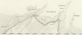
English: North end of earlier Holy Island Waggonway to a jetty on the SW of the island |
| Date | Surveyed: 1860; Published: 1866 |
| Source | 1860 6" OS map Northumberland XII (includes: Elwick; Holy Island; Kyloe; Ross) provided by National Library of Scotland |
| Author | Ordnance Survey, six-inch England and Wales, 1842-1952 |
Licensing
[edit]
|
This work is in the public domain in its country of origin and other countries and areas where the copyright term is the author's life plus 70 years or fewer. This work is in the public domain in the United States because it was published (or registered with the U.S. Copyright Office) before January 1, 1929. | |
| This file has been identified as being free of known restrictions under copyright law, including all related and neighboring rights. | |
File history
Click on a date/time to view the file as it appeared at that time.
| Date/Time | Thumbnail | Dimensions | User | Comment | |
|---|---|---|---|---|---|
| current | 12:22, 27 June 2016 | | 1,439 × 616 (1,015 KB) | NearEMPTiness (talk | contribs) | User created page with UploadWizard |
You cannot overwrite this file.
File usage on Commons
The following page uses this file: