File:Northeast Kenya ESA416349.jpg

Original file (5,490 × 5,490 pixels, file size: 6.92 MB, MIME type: image/jpeg)
Captions
Captions
Summary
[edit]| Description |
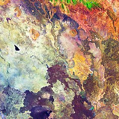
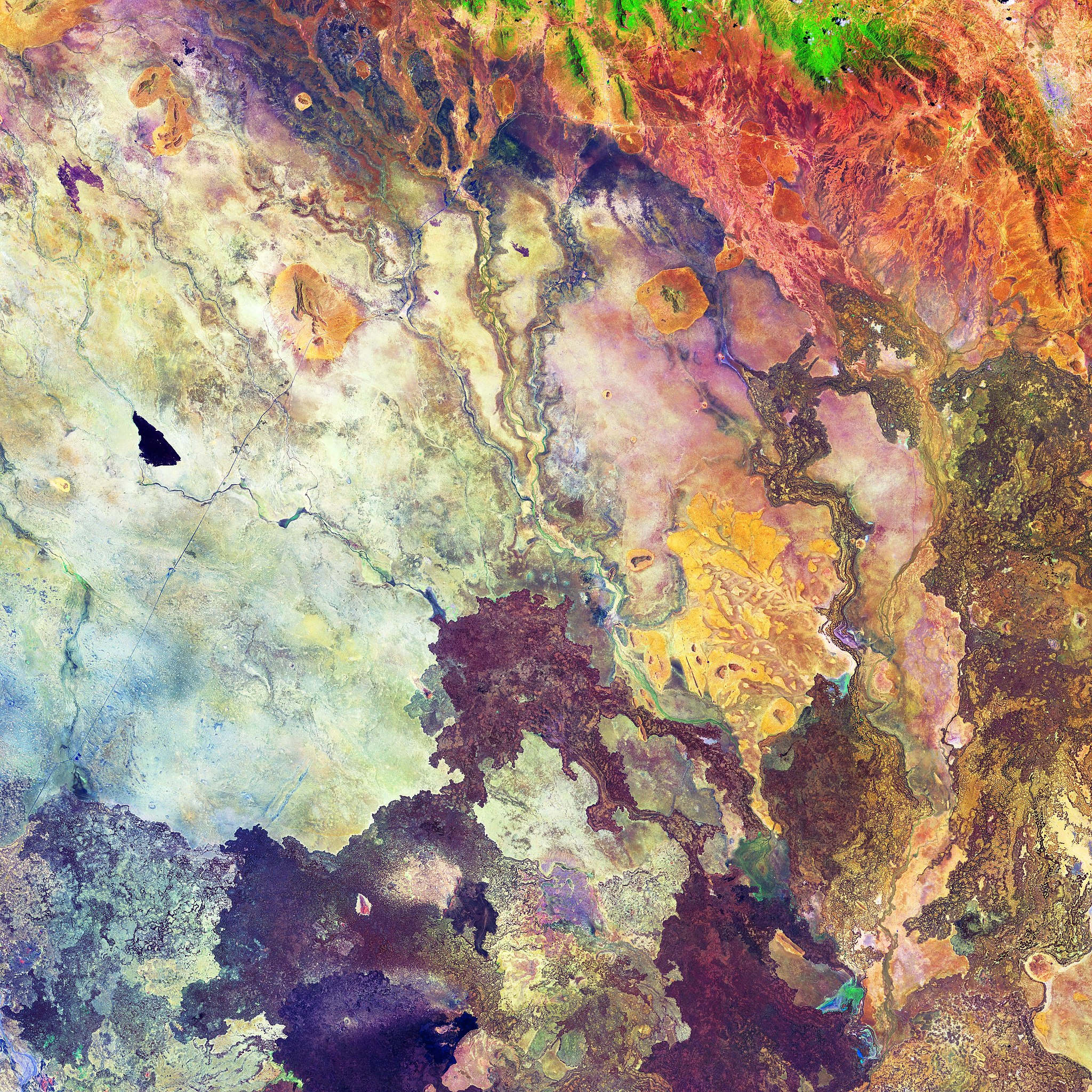
Captured on 1 October 2018 by the Copernicus Sentinel-2A satellite, this image features part of northeast Kenya – an area east of the East African Rift. The region tends to be very arid and this false-colour image has been processed to highlight different types of rock, soil and sand in pinks, purples and yellows. The bright green at the top of the image depicts vegetation, but the rest of the area appears relatively devoid of vegetation. Several dry river beds can also be seen etched into the landscape and the black shape in the middle-left appears to be an area of freshly burnt land. The lack of water has, at times, led to clashes between clans over access to water and pasture for cattle. When the rains do come, however, this dry dusty land can burst into life and turn a rich green. Part of the ‘great north road’ can also been seen running from the bottom-left to the top-right. The road is one of the best in the country, linking Nairobi in the south of the country to Ethiopia. The northern 500-km stretch from Isiolo to the Kenyan–Ethiopian border town of Moyale took about nine years to build and was completed recently, but has reduced travel time from Nairobi to Moyale from three days to about 12 hours and opened up new opportunities for trade and business. Moyale can be seen in the top-right of the image. Copernicus Sentinel-2 is a two-satellite mission. Each satellite carries a high-resolution camera that images Earth’s surface in 13 spectral bands. The mission is mostly used to track changes in the way land is being used and to monitor the health of our vegetation. This Copernicus Sentinel-2A image is also featured on the Earth from Space video programme. |
| Date | |
| Source | http://www.esa.int/spaceinimages/Images/2019/02/Northeast_Kenya |
| Author | European Space Agency |
| Permission (Reusing this file) |
contains modified Copernicus Sentinel data (2018), processed by ESA, CC BY-SA 3.0 IGO |
| Other versions |
|

Licensing
[edit]
This media was created by the European Space Agency (ESA).
Where expressly so stated, images or videos are covered by the Creative Commons Attribution-ShareAlike 3.0 IGO (CC BY-SA 3.0 IGO) licence, ESA being an Intergovernmental Organisation (IGO), as defined by the CC BY-SA 3.0 IGO licence. The user is allowed under the terms and conditions of the CC BY-SA 3.0 IGO license to Reproduce, Distribute and Publicly Perform the ESA images and videos released under CC BY-SA 3.0 IGO licence and the Adaptations thereof, without further explicit permission being necessary, for as long as the user complies with the conditions and restrictions set forth in the CC BY-SA 3.0 IGO licence, these including that:
See the ESA Creative Commons copyright notice for complete information, and this article for additional details.
|
 | |
This file is licensed under the Creative Commons Attribution-ShareAlike 3.0 IGO license. Attribution: ESA, CC BY-SA IGO 3.0
| ||

|
This image contains data from a satellite in the Copernicus Programme, such as Sentinel-1, Sentinel-2 or Sentinel-3. Attribution is required when using this image.
Attribution: Contains modified Copernicus Sentinel data 2018
The use of Copernicus Sentinel Data is regulated under EU law (Commission Delegated Regulation (EU) No 1159/2013 and Regulation (EU) No 377/2014). Relevant excerpts:
Free access shall be given to GMES dedicated data [...] made available through GMES dissemination platforms [...].
Access to GMES dedicated data [...] shall be given for the purpose of the following use in so far as it is lawful:
GMES dedicated data [...] may be used worldwide without limitations in time.
GMES dedicated data and GMES service information are provided to users without any express or implied warranty, including as regards quality and suitability for any purpose. |
File history
Click on a date/time to view the file as it appeared at that time.
| Date/Time | Thumbnail | Dimensions | User | Comment | |
|---|---|---|---|---|---|
| current | 01:00, 9 February 2019 | | 5,490 × 5,490 (6.92 MB) | Don-vip (talk | contribs) |
You cannot overwrite this file.
File usage on Commons
The following 4 pages use this file:
.jpg&redirect=no)