File:NorthernWallkillValley.png
跳至導覽
跳至搜尋

預覽大小:366 × 599 像素。 其他解析度:147 × 240 像素 | 293 × 480 像素 | 1,011 × 1,654 像素。
原始檔案 (1,011 × 1,654 像素,檔案大小:2.82 MB,MIME 類型:image/png)
說明
說明
添加單行說明來描述出檔案所代表的內容
摘要
[編輯]
| 描述 |
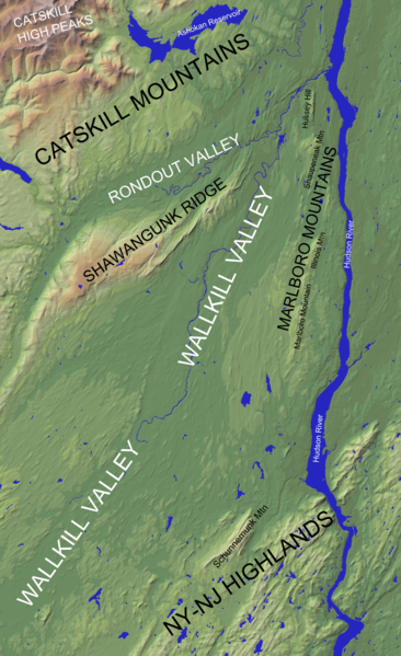
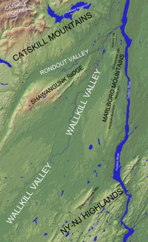
English: Section of a north-up oriented shaded relief map of the U.S. state of New York (from the United States Geological Survey) showing the extent of the northern Wallkill Valley. Geographic features have been labeled |
| 日期 | |
| 來源 | |
| 作者 |
|
| 這是一張修飾過的圖片,即本圖片是用軟體修改過後的版本,修改的方式或內容有:Cropped from original USGS work, lightened, and added labels。原版圖片來源:New York Relief 1.jpg。修改者:Lithium6ion。
|
|
|
檔案歷史
點選日期/時間以檢視該時間的檔案版本。
| 日期/時間 | 縮圖 | 尺寸 | 使用者 | 備註 | |
|---|---|---|---|---|---|
| 目前 | 2014年10月18日 (六) 04:24 | | 1,011 × 1,654(2.82 MB) | Lithium6ion(留言 | 貢獻) | {{Information |Description ={{en|1=Section of a north-up oriented shaded relief map of the U.S. state of New York (from the United States Geological Survey) showing the extent of the Wallkill Valley. Geographic features have... |
無法覆蓋此檔案。
檔案用途
沒有使用此檔案的頁面。
全域檔案使用狀況
以下其他 wiki 使用了這個檔案:
- en.wikipedia.org 的使用狀況
- zh.wikipedia.org 的使用狀況