File:Northern Ireland in the UK and Europe.svg
ナビゲーションに移動
検索に移動

この SVG ファイルのこの PNG プレビューのサイズ: 713 × 600 ピクセル. その他の解像度: 285 × 240 ピクセル | 571 × 480 ピクセル | 913 × 768 ピクセル | 1,218 × 1,024 ピクセル | 2,435 × 2,048 ピクセル | 2,045 × 1,720 ピクセル。
元のファイル (SVG ファイル、2,045 × 1,720 ピクセル、ファイルサイズ: 7.84メガバイト)
キャプション
キャプション
このファイルの内容を1行で記述してください
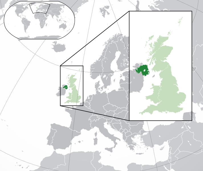
Map of Northern Ireland
概要
[編集]| 解説 |
English: A map of Northern Ireland within the United Kingdom and Europe. The map is a polar orthographic projection.
Northern Ireland
Great Britain/United Kingdom except Northern Ireland
Europe (except UK) Français : Une carte de l'Irlande du Nord au sein du Royaume-Uni et en Europe. La carte est un polair projection orthographique.
Irlande du Nord
Grande-Bretagne/Royaume-Unie sauf l'Irlande du Nord
Europe (sauf le Royaume-Unie) Deutsch: Eine Karte der Nordirland drinnen das Vereinigtes Königreich und drinnen Europa. Die Karte ist ein polare orthografische Azimutalprojektion.
Nordirland
Großbritannien/Vereinigtes Königreich außer Nordirland
Europa (außer das Vereinigtes Königreich) Cymraeg:
Gogledd Iwerddon
Y Deyrnas Unedig
Ewrop Gàidhlig:
Èirinn a Tuath
An Rìoghachd Aonaichte
An Roinn-Eòrpa Gaeilge: Tuaisceart Éireann
An Ríocht Aontaithe
An Eoraip |
| 日付 | (UTC) |
| 原典 |
このファイルの派生元: Blank map of Europe (with disputed regions).svg: |
| 作者 |
|
| その他のバージョン |
|
| SVG 開発 |


.svg)
ライセンス
[編集]
このファイルはクリエイティブ・コモンズ 表示-継承 3.0 非移植ライセンスのもとに利用を許諾されています。
- あなたは以下の条件に従う場合に限り、自由に
- 共有 – 本作品を複製、頒布、展示、実演できます。
- 再構成 – 二次的著作物を作成できます。
- あなたの従うべき条件は以下の通りです。
- 表示 – あなたは適切なクレジットを表示し、ライセンスへのリンクを提供し、変更があったらその旨を示さなければなりません。これらは合理的であればどのような方法で行っても構いませんが、許諾者があなたやあなたの利用行為を支持していると示唆するような方法は除きます。
- 継承 – もしあなたがこの作品をリミックスしたり、改変したり、加工した場合には、あなたはあなたの貢献部分を元の作品とこれと同一または互換性があるライセンスの下に頒布しなければなりません。
元のアップロードログ
[編集]
This image is a derivative work of the following images:
- File:Blank_map_of_Europe.svg licensed with Cc-by-sa-2.5
- 2012-02-21T16:27:27Z Alphathon 680x520 (614699 Bytes) Updated Metadata and the boarders/coastlines along the western coast of the Black Sea
- 2011-09-19T22:57:58Z Alphathon 680x520 (603759 Bytes) Added North/Northern Cyprus
- 2011-08-23T10:26:48Z Heb 680x520 (604212 Bytes) Added [[:en:Bornholm]] (taken from [[:File:Denmark blank map.svg]])
- 2011-04-12T00:40:40Z Alphathon 680x520 (602549 Bytes) Upgraded Sicily based on "File:Freeworldmaps-sicily.jpg". Upgraded Malta based on "File:Map of Malta 2.png". Simplified Croatian borders.
- 2011-04-10T21:43:04Z Alphathon 680x520 (607359 Bytes) Upgraded Croatia, Bosnia & Herzegovina, Slovenia and surrounding countries based on data from "File:Kroatien - Politische Gliederung (Karte).png"
- 2011-04-10T20:05:09Z Alphathon 680x520 (568373 Bytes) Improved Serbia, Montenegro and surrounding countries using data from "File:Serbia Map.png". Fixed Serbia-Montenegro border. Added Kosovo (using dashed border, since it is not a universally recognised nation, and left the lan
- 2011-04-10T15:55:02Z Alphathon 680x520 (524980 Bytes) Tweaked Ukraine and surrounding countries based on data from "File:Up-map.png"
- 2011-04-10T04:02:09Z Alphathon 680x520 (511168 Bytes) Improved Greece, Albania, F.Y.R. Macedonia and Bulgaria based on "File:Greece topo.jpg"
- 2011-04-10T02:48:52Z Alphathon 680x520 (505569 Bytes) Tweaked Germany and surrounding countries based on info from "File:Germany_general_map.png"
- 2011-04-10T01:54:05Z Alphathon 680x520 (493733 Bytes) Converted all lakes back to separate layer. Added Finish lakes and tweaked Finland shape based on "File:Finland 1996 CIA map.jpg". Added Swiss lakes based on "File:Suisse cantons.svg". Tweaked Scotland and added Lochs.
- 2011-04-10T00:07:54Z Alphathon 680x520 (450120 Bytes) Improved England outline and added Isle of Wight based on "File:England Regions - Blank.svg". Improved Denmark based on "File:2 digit postcode danmark.png". Improved Sweden based on "File:Map of Sweden, CIA, 1996.jpg"
- 2011-04-08T15:53:07Z Alphathon 680x520 (438878 Bytes) Upgraded/fixed various parts of the map. Details: *Some minor fixes to Ireland and added some of the larger lakes based on [[:File:Ireland_trad_counties_named.svg]] *Pretty major fixes to Scotland (mainly the west coast and i
- 2008-09-17T09:50:25Z F7 680x520 (531491 Bytes)
- 2008-09-17T09:42:57Z F7 680x520 (2353 Bytes)
- 2008-05-26T19:04:07Z Collard 680x520 (531491 Bytes) uploading on behalf of [[User:Checkit]], direct complaints to him plox: 'Moved countries out of the "outlines" group, removed "outlines" style class, remove separate style information for Russia'
- 2008-04-30T01:38:52Z TimothyBourke 680x520 (531767 Bytes) Changed the country code of Serbia to RS per [http://en.wikipedia.org/wiki/Serbian_country_codes] and the file [http://www.iso.org/iso/iso3166_en_code_lists.txt].
- 2008-02-08T22:44:37Z CarolSpears 680x520 (531767 Bytes) validated
- 2007-07-10T11:47:59Z MrWeeble 680x520 (533112 Bytes) Updated to include British Crown Dependencies as seperate entities and regroup them as "British Islands", with some simplifications to the XML and CSS
- 2007-05-14T17:17:34Z Zirland 680x520 (540659 Bytes) serbia and montenegro
- 2007-03-30T20:40:49Z W!B: 680x520 (538830 Bytes) minor corr: update nl:Ijsselmeer, del fi:lakes (all small), add ru:lake Oneka (all ref maps.google), glued northern irland back to ie ;)
- 2007-02-05T18:44:32Z Maix 680x520 (538295 Bytes) cropped
- 2007-02-04T15:07:29Z Maix 680x520 (538310 Bytes) {{Information |Description=A blank Map of Europe in SVG format. Every country has an id which is its ISO-3116-1-ALPHA2 code in lower case for easy coloring. |Source=Image based on [[Image:Europe_countries.svg|]] by [[User:Ti
Uploaded with derivativeFX
ファイルの履歴
過去の版のファイルを表示するには、その版の日時をクリックしてください。
| 日付と時刻 | サムネイル | 寸法 | 利用者 | コメント | |
|---|---|---|---|---|---|
| 現在の版 | 2014年8月6日 (水) 20:00 | | 2,045 × 1,720 (7.84メガバイト) | Rob984 (トーク | 投稿記録) | Improved version: More accurate coastline, borders, etc. Added Gradient and Longitude and latitude lines. Zoom insert centred on UK. |
| 2014年2月21日 (金) 14:57 |  | 680 × 520 (2.48メガバイト) | Rob984 (トーク | 投稿記録) | White background so that the edge of the map is clear. Consistency with other European countries' maps also. | |
| 2013年1月19日 (土) 18:24 |  | 680 × 520 (2.46メガバイト) | Alphathon (トーク | 投稿記録) | Added Robinson projection to top left corner. | |
| 2012年2月26日 (日) 23:38 |  | 680 × 520 (941キロバイト) | Alphathon (トーク | 投稿記録) | Fixed XML | |
| 2012年2月26日 (日) 23:34 |  | 680 × 520 (941キロバイト) | Alphathon (トーク | 投稿記録) | More detailed version of the British Isles | |
| 2012年2月26日 (日) 00:36 |  | 680 × 520 (789キロバイト) | Alphathon (トーク | 投稿記録) | Added missing parts of Belgium and the Netherlands. | |
| 2012年2月25日 (土) 22:36 |  | 680 × 520 (806キロバイト) | Alphathon (トーク | 投稿記録) | == {{int:filedesc}} == {{Information |Description={{en|A map of Northern Ireland (dark green) within the United Kingdom (dark and light green) and Europe (dark green, light green and darker grey).}} |Source={{Derived from|Blank_map_of_Europe.svg|displa... |
このファイルは上書きできません。
ファイルの使用状況
このファイルへは 100 を超える数のページで使用されています。 以下の一覧ではこのファイルを使用している最初の 100 ページのみを表示しています。 完全な一覧も参照してください。
- Northern Ireland
- Category:Academics from Northern Ireland
- Category:Agriculture in Northern Ireland
- Category:Airports in Northern Ireland
- Category:Archaeological sites in Northern Ireland
- Category:Archaeological sites in Northern Ireland by county
- Category:Architecture of Northern Ireland
- Category:Art Deco architecture in Northern Ireland
- Category:Association football clubs in Northern Ireland
- Category:Association football players from Northern Ireland
- Category:Association football venues in Northern Ireland
- Category:Augustinian monasteries in Northern Ireland
- Category:Aviation in Northern Ireland
- Category:Bridges in Northern Ireland
- Category:Canals in Northern Ireland
- Category:Castles in Northern Ireland
- Category:Caves of Northern Ireland
- Category:Cemeteries in Northern Ireland
- Category:Chefs from Northern Ireland
- Category:Churches in Northern Ireland
- Category:Cinemas in Northern Ireland
- Category:Cistercian monasteries in Northern Ireland
- Category:Cities in Northern Ireland
- Category:Companies of Northern Ireland
- Category:Disc jockeys from Northern Ireland
- Category:Dolmens in Northern Ireland
- Category:Environment of Northern Ireland
- Category:Events in Northern Ireland
- Category:Fairs in Northern Ireland
- Category:Geology of Northern Ireland
- Category:Golf in Northern Ireland
- Category:Hamlets in Northern Ireland
- Category:Heritage railways in Northern Ireland
- Category:Higher education institutions in Northern Ireland
- Category:Hotels in Northern Ireland
- Category:Houses in Northern Ireland
- Category:Industry in Northern Ireland
- Category:Islands of Northern Ireland
- Category:Libraries in Northern Ireland
- Category:Lighthouses in Northern Ireland
- Category:Lighthouses in Northern Ireland by name
- Category:Male sportspeople from Northern Ireland
- Category:Maps of Northern Ireland
- Category:Men of Northern Ireland
- Category:Mining in Northern Ireland
- Category:Monasteries in Northern Ireland
- Category:Motorcycle racers from Northern Ireland
- Category:Museums in Northern Ireland
- Category:Music of Northern Ireland
- Category:Musical groups from Northern Ireland
- Category:Musicians from Northern Ireland
- Category:Natural gas-fired power plants in Northern Ireland
- Category:Nature reserves in Northern Ireland
- Category:Northern Ireland
- Category:Northern Ireland in the 1920s
- Category:Northern Ireland in the 1930s
- Category:Northern Ireland in the 1940s
- Category:Northern Ireland in the 1960s
- Category:Northern Ireland in the 1970s
- Category:Northern Ireland in the 1980s
- Category:Northern Ireland in the 1990s
- Category:Northern Ireland in the 2000s
- Category:Northern Ireland in the 2010s
- Category:Painters from Northern Ireland
- Category:Parks in Northern Ireland
- Category:Players of Northern Ireland national association football team
- Category:Poets from Northern Ireland
- Category:Political parties in Northern Ireland
- Category:Ports and harbours in Northern Ireland
- Category:Power plants in Northern Ireland
- Category:Prisons in Northern Ireland
- Category:Public art in Northern Ireland
- Category:Racecar drivers from Northern Ireland
- Category:Rail transport in Northern Ireland
- Category:Rail transport infrastructure in Northern Ireland
- Category:Railway bridges in Northern Ireland
- Category:Railway stations in Northern Ireland
- Category:Restaurants in Northern Ireland
- Category:Rivers of Northern Ireland
- Category:Scheduled monuments in Northern Ireland
- Category:Schools in Northern Ireland
- Category:Scientists from Northern Ireland
- Category:Sculptors from Northern Ireland
- Category:Skyscrapers in Northern Ireland
- Category:Snooker players from Northern Ireland
- Category:Sports venues in Northern Ireland
- Category:Stadiums in Northern Ireland
- Category:Streets in Northern Ireland
- Category:Tower houses in Northern Ireland
- Category:Towers in Northern Ireland
- Category:Town halls in Northern Ireland
- Category:Towns in Northern Ireland
- Category:Visitor attractions in Northern Ireland by county
- Category:Walls in Northern Ireland
- Category:Water transport in Northern Ireland
- Category:Watermills in Northern Ireland
- Category:Wetlands of Northern Ireland
- Category:Wind farms in Northern Ireland
- Category:Windmills in Northern Ireland
- Category:Women of Northern Ireland
このファイルへのリンク元を更にを表示する。
グローバルなファイル使用状況
以下に挙げる他のウィキがこの画像を使っています:
- af.wikipedia.org での使用状況
- af.wiktionary.org での使用状況
- am.wikipedia.org での使用状況
- ang.wikipedia.org での使用状況
- ar.wikipedia.org での使用状況
- arz.wikipedia.org での使用状況
- az.wikipedia.org での使用状況
- be-tarask.wikipedia.org での使用状況
- be.wikipedia.org での使用状況
- bew.wikipedia.org での使用状況
- bg.wikipedia.org での使用状況
- bh.wikipedia.org での使用状況
- blk.wikipedia.org での使用状況
- bn.wikipedia.org での使用状況
- bn.wiktionary.org での使用状況
- bs.wikipedia.org での使用状況
- bxr.wikipedia.org での使用状況
- ca.wikipedia.org での使用状況
- cdo.wikipedia.org での使用状況
- chy.wikipedia.org での使用状況
- diq.wikipedia.org での使用状況
- el.wikipedia.org での使用状況
- en.wikipedia.org での使用状況
- en.wikinews.org での使用状況
- en.wiktionary.org での使用状況
- eo.wikipedia.org での使用状況
- es.wikipedia.org での使用状況
- et.wikipedia.org での使用状況
- fa.wikipedia.org での使用状況
- fa.wikivoyage.org での使用状況
- fi.wikipedia.org での使用状況
このファイルのグローバル使用状況を表示する。