File:Northwest Sardinia ESA15501900.jpeg
Original file (2,187 × 1,158 pixels, file size: 1.34 MB, MIME type: image/jpeg)
Captions
Captions
Summary
[edit]
| Description |
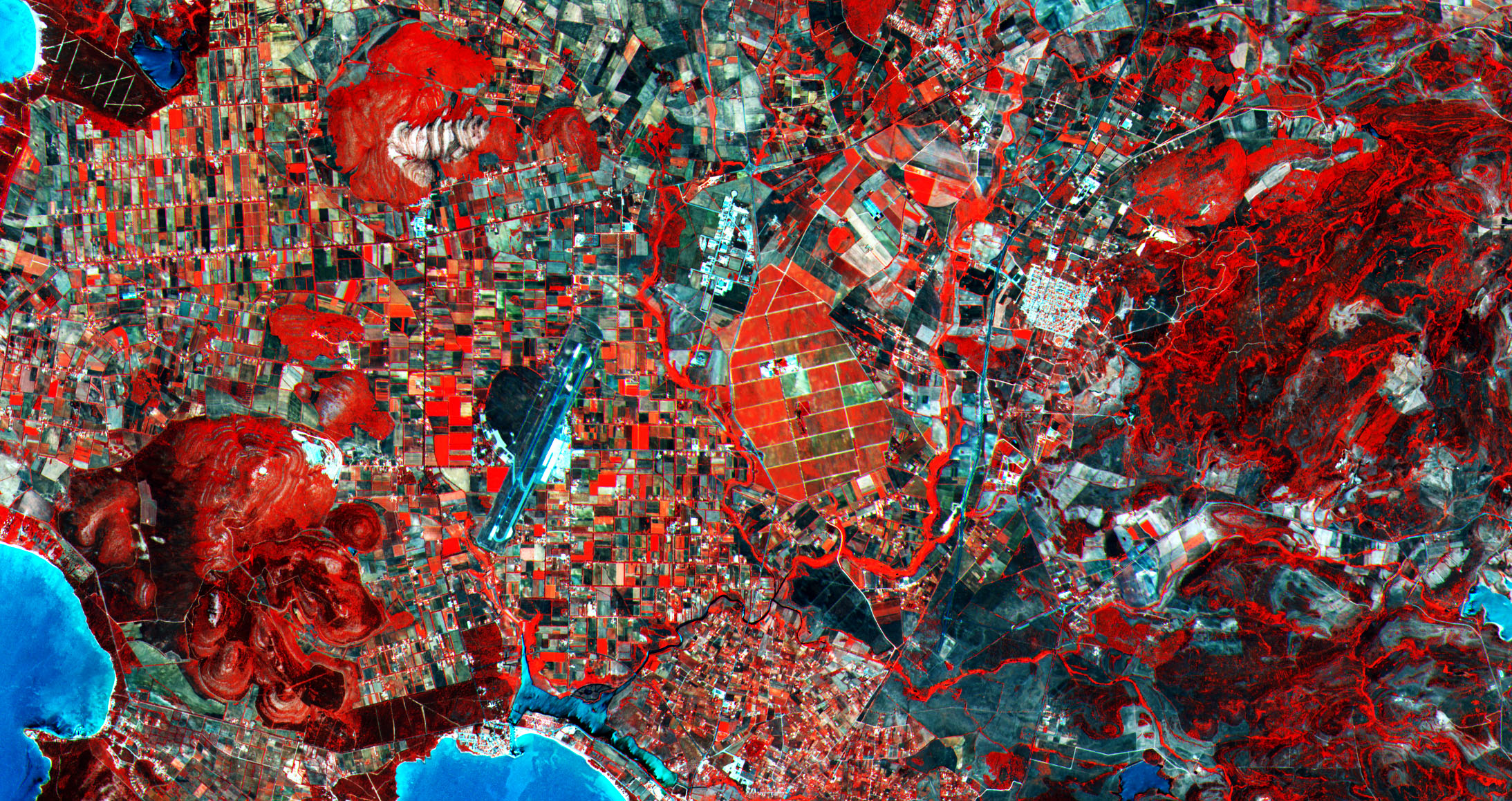
English: This image over part of the Italian island of Sardinia comes from the very first acquisition by the Sentinel-2A satellite. Launched in the early hours of 23 June, the ‘colour vision’ mission for Europe’s Copernicus programme delivered its first image of Earth on 27 June, which covered a 290 km-wide strip from Sweden down to Algeria – including part of Sardinia. The area pictured covers a section of the island’s northwestern Sassari province, with parts of the coast visible along the left side and bottom. Agricultural fields dominate the inland, with a large area of vineyards at the centre of the image. While the satellite mission will provide optical data for land monitoring, its main instrument has 13 spectral bands. This false-colour image was processed including the instrument’s near infrared spectral channel – which explains why plants in the area pictured appear red. The varying shades of red and other colours across the entire image indicate how sensitive the multispectral instrument is to differences in chlorophyll content. This is used to provide key information on plant health and, for this image, the brighter reds indicate healthier vegetation. In the lower left section, we can see a large hilly area with significant vegetation – indicated by the red colouring. However, a bright white/light-blue section of this area shows where the hills have been cut into for surface mining. In some areas, the agricultural fields appear outlined in red as well. This comes from the presence of hedges, which may have been planted to protect the crops from wind. Such hedges provide a habitat for smaller animal species and birds, so even small-scale habitat monitoring can be performed by Sentinel-2. Other visible features in this image include the Alghero-Fertilia Airport just left of the centre, and the port of Fertilia directly to its south. Near the port, the waters of a lagoon appear different compared to the waters of the sea to its south, because of the difference in chemical composition. This first acquisition by the satellite already demonstrates Sentinel-2’s application for monitoring inland and coastal waters. This image is featured on the Earth from Space video programme. |
| Date | 3 July 2015 (upload date) |
| Source | Northwest Sardinia |
| Author | European Space Agency |
| Activity | Observing the Earth |
| Keyword | Satellite image |
| Location | Italy |
| Mission | Sentinel-2 |
| Set | Earth observation image of the week |
| System | Copernicus |
Licensing
[edit]

|
This image contains data from a satellite in the Copernicus Programme, such as Sentinel-1, Sentinel-2 or Sentinel-3. Attribution is required when using this image.
Attribution: Contains modified Copernicus Sentinel data 2015
The use of Copernicus Sentinel Data is regulated under EU law (Commission Delegated Regulation (EU) No 1159/2013 and Regulation (EU) No 377/2014). Relevant excerpts:
Free access shall be given to GMES dedicated data [...] made available through GMES dissemination platforms [...].
Access to GMES dedicated data [...] shall be given for the purpose of the following use in so far as it is lawful:
GMES dedicated data [...] may be used worldwide without limitations in time.
GMES dedicated data and GMES service information are provided to users without any express or implied warranty, including as regards quality and suitability for any purpose. |
This media was created by the European Space Agency (ESA).
Where expressly so stated, images or videos are covered by the Creative Commons Attribution-ShareAlike 3.0 IGO (CC BY-SA 3.0 IGO) licence, ESA being an Intergovernmental Organisation (IGO), as defined by the CC BY-SA 3.0 IGO licence. The user is allowed under the terms and conditions of the CC BY-SA 3.0 IGO license to Reproduce, Distribute and Publicly Perform the ESA images and videos released under CC BY-SA 3.0 IGO licence and the Adaptations thereof, without further explicit permission being necessary, for as long as the user complies with the conditions and restrictions set forth in the CC BY-SA 3.0 IGO licence, these including that:
See the ESA Creative Commons copyright notice for complete information, and this article for additional details.
|
 | |
This file is licensed under the Creative Commons Attribution-ShareAlike 3.0 IGO license. Attribution: ESA, CC BY-SA IGO 3.0
| ||
File history
Click on a date/time to view the file as it appeared at that time.
| Date/Time | Thumbnail | Dimensions | User | Comment | |
|---|---|---|---|---|---|
| current | 21:05, 11 June 2020 | | 2,187 × 1,158 (1.34 MB) | OptimusPrimeBot (talk | contribs) | #Spacemedia - Upload of https://www.esa.int/var/esa/storage/images/esa_multimedia/images/2015/07/northwest_sardinia/15501891-1-eng-GB/Northwest_Sardinia.jpg via Commons:Spacemedia |
You cannot overwrite this file.
File usage on Commons
There are no pages that use this file.