File:Nouvelle Carte Hydrographique et Routière de la Suisse.jpg
Jump to navigation
Jump to search

Size of this preview: 800 × 561 pixels. Other resolutions: 320 × 224 pixels | 640 × 449 pixels | 1,024 × 718 pixels | 1,280 × 897 pixels | 2,560 × 1,794 pixels | 11,314 × 7,930 pixels.
Original file (11,314 × 7,930 pixels, file size: 14.45 MB, MIME type: image/jpeg)
Captions
Captions
Add a one-line explanation of what this file represents
Summary
[edit]
| Warning | The original file is very high-resolution. It might not load properly or could cause your browser to freeze when opened at full size. |
|---|
| Description |
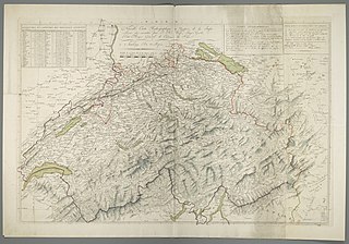
Deutsch: 1 Kt. : teilw. kolor. (85 x 54 cm) ; Koordinaten E 6°01'00"-E 11°00'00"/N 48°04'00"-N 45°48'00" ; Maßstab in graph. Form (Lieues). - Titel und Maßstab oben Mitte. - Mit Tab. mit geogr. Koordinaten oben links. - Mit Erl. oben rechts. - Relief: Bergstriche |
| Date | |
| Source | Leibniz-Institut für Länderkunde e.V., Leipzig |
| Author | Weiß, Johann Heinrich |
Altkarte ; Gewässerkarte ; Verkehrskarte
Licensing
[edit]
| This file is made available under the Creative Commons CC0 1.0 Universal Public Domain Dedication. | |
| The person who associated a work with this deed has dedicated the work to the public domain by waiving all of their rights to the work worldwide under copyright law, including all related and neighboring rights, to the extent allowed by law. You can copy, modify, distribute and perform the work, even for commercial purposes, all without asking permission.
|
File history
Click on a date/time to view the file as it appeared at that time.
| Date/Time | Thumbnail | Dimensions | User | Comment | |
|---|---|---|---|---|---|
| current | 14:05, 8 January 2019 | | 11,314 × 7,930 (14.45 MB) | Higgenhorscht (talk | contribs) | User created page with UploadWizard |
You cannot overwrite this file.
File usage on Commons
There are no pages that use this file.