File:Nova Scotia counties 2015.png
Jump to navigation
Jump to search

Size of this preview: 698 × 600 pixels. Other resolutions: 279 × 240 pixels | 559 × 480 pixels | 894 × 768 pixels | 1,192 × 1,024 pixels | 2,384 × 2,048 pixels | 3,400 × 2,921 pixels.
Original file (3,400 × 2,921 pixels, file size: 221 KB, MIME type: image/png)
Captions
Captions
Add a one-line explanation of what this file represents
Summary
[edit]
| Description |
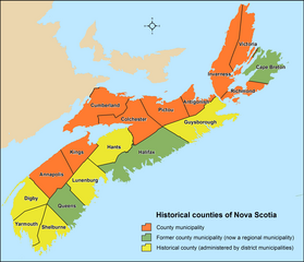
English: Distribution of Nova Scotia's 18 historical counties (census divisions) utilizing Statistics Canada's 2011 census division boundaries. |
| Date | |
| Source | Own work |
| Author | Hwy43 |
Licensing
[edit]
I, the copyright holder of this work, hereby publish it under the following license:
This file is licensed under the Creative Commons Attribution 4.0 International license.
- You are free:
- to share – to copy, distribute and transmit the work
- to remix – to adapt the work
- Under the following conditions:
- attribution – You must give appropriate credit, provide a link to the license, and indicate if changes were made. You may do so in any reasonable manner, but not in any way that suggests the licensor endorses you or your use.
File history
Click on a date/time to view the file as it appeared at that time.
| Date/Time | Thumbnail | Dimensions | User | Comment | |
|---|---|---|---|---|---|
| current | 01:43, 2 January 2016 | | 3,400 × 2,921 (221 KB) | Hwy43 (talk | contribs) | minor legend adjustments |
| 23:24, 1 January 2016 |  | 3,400 × 2,921 (220 KB) | Hwy43 (talk | contribs) | symbolize historical counties by incorporated municipal status | |
| 20:21, 1 January 2016 |  | 3,400 × 2,921 (207 KB) | Hwy43 (talk | contribs) | User created page with UploadWizard |
You cannot overwrite this file.
File usage on Commons
There are no pages that use this file.
File usage on other wikis
The following other wikis use this file:
- Usage on de.wikipedia.org
- Usage on en.wikipedia.org
- Usage on fr.wikipedia.org
- Usage on pt.wikipedia.org
- Usage on pt.wikinews.org
- Usage on zh.wikipedia.org