File:Nowa Sól (gmina wiejska) location map.png

Original file (2,298 × 1,727 pixels, file size: 473 KB, MIME type: image/png)
Captions
Captions
Summary
[edit]_location_map.png&action=edit§ion=1)
| Description |
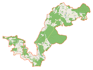
English: Location map |
| Date | |
| Source | Own work |
| Author | Smat |
| Description |
Polski: Mapa gminy wiejskiej Nowa Sól, Polska
English: Map of Nowa Sól (gmina wiejska), Poland |
|||||||||
| Date | ||||||||||
| Source | You may find a page on the OpenStreetMap wiki page for Nowa Sól (gmina wiejska) | |||||||||
| Creator |
OpenStreetMap contributors OpenStreetMap contributors |
|||||||||
| Permission (Reusing this file) |
OpenStreetMap data is available under the Open Database License (details). Map tiles are licensed under the Creative Commons Attribution-ShareAlike 2.0 license (CC-BY-SA 2.0).
This file is licensed under the Creative Commons Attribution-Share Alike 2.0 Generic license.
|
|||||||||
| Geotemporal data | ||||||||||
| Bounding box |
|
|||||||||
| Georeferencing | If inappropriate please set warp_status = skip to hide. | |||||||||
Licensing
[edit]_location_map.png&action=edit§ion=2)
| This work contains information from OpenStreetMap, which is made available under the Open Database License (ODbL).
The ODbL does not require any particular license for maps produced from ODbL data. Prior to 1 August 2020, map tiles produced by the OpenStreetMap Foundation were licensed under the CC-BY-SA-2.0 license. Maps produced by other people may be subject to other licences. |
File history
Click on a date/time to view the file as it appeared at that time.
| Date/Time | Thumbnail | Dimensions | User | Comment | |
|---|---|---|---|---|---|
| current | 09:38, 21 September 2017 | | 2,298 × 1,727 (473 KB) | Smat (talk | contribs) | new |
| 15:38, 12 May 2017 |  | 2,298 × 1,727 (1.86 MB) | Smat (talk | contribs) | User created page with UploadWizard |
You cannot overwrite this file.
File usage on Commons
There are no pages that use this file.
File usage on other wikis
The following other wikis use this file:
- Usage on pl.wikipedia.org
- Kiełcz
- Lelechów
- Lubięcin
- Nowe Żabno
- Stary Staw (województwo lubuskie)
- Wrociszów
- Buczków (województwo lubuskie)
- Chełmek (województwo lubuskie)
- Ciepielów (województwo lubuskie)
- Dąbrowno (województwo lubuskie)
- Jeziorna (województwo lubuskie)
- Jodłów (województwo lubuskie)
- Lipiny (województwo lubuskie)
- Rudno (województwo lubuskie)
- Stany (województwo lubuskie)
- Stara Wieś (województwo lubuskie)
- Lubieszów (powiat nowosolski)
- Przyborów (powiat nowosolski)
- Drogoniów
- Radosławice
- Stawy (Lubięcin)
- Józefów (Jeziorna)
- Okopiec
- Odra (województwo lubuskie)
- Porębów
- Cerkiew św. Michała Archanioła w Lipinach
- Parafia św. Michała Archanioła w Lipinach
- Most kolejowy w Stanach
- Lubięcin (przystanek kolejowy)
- Lipiny Odrzańskie
- Stany (przystanek kolejowy)
- Ciepielów (przystanek kolejowy)
- Moduł:Mapa/dane/Nowa Sól (gmina wiejska)
- Kościół Najświętszego Serca Pana Jezusa w Lubięcinie
- Parafia Matki Bożej Częstochowskiej w Przyborowie
- Parafia Świętej Rodziny w Lubieszowie
- Parafia Najświętszego Serca Jezusowego w Lubięcinie
- Dzwonnica w Stanach
- Usage on pl.wikibooks.org
_location_map.png&oldid=607600744)