File:Nunataker hg.jpg
Jump to navigation
Jump to search

Size of this preview: 800 × 472 pixels. Other resolutions: 320 × 189 pixels | 640 × 378 pixels | 1,024 × 604 pixels | 1,280 × 755 pixels | 2,560 × 1,510 pixels.
Original file (2,560 × 1,510 pixels, file size: 667 KB, MIME type: image/jpeg)
Captions
Captions
Add a one-line explanation of what this file represents
| Camera location | | View this and other nearby images on: OpenStreetMap |
|---|
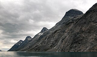
| Description | Prins Christians Sund, South Greenland with Nunataker along the coast, formed during the full glaciation of the area. |
| Date | |
| Source | Own work |
| Author | Hannes Grobe/AWI |
| Other versions |
 |
This file is licensed under the Creative Commons Attribution 3.0 Unported license.
- You are free:
- to share – to copy, distribute and transmit the work
- to remix – to adapt the work
- Under the following conditions:
- attribution – You must give appropriate credit, provide a link to the license, and indicate if changes were made. You may do so in any reasonable manner, but not in any way that suggests the licensor endorses you or your use.
File history
Click on a date/time to view the file as it appeared at that time.
| Date/Time | Thumbnail | Dimensions | User | Comment | |
|---|---|---|---|---|---|
| current | 02:12, 26 December 2008 | | 2,560 × 1,510 (667 KB) | Hgrobe (talk | contribs) | {{Information |Description= |Source=own work |Date=2008 |Author=~~~ |Permission=Attribution 2.5 |other_versions= }} {{cc-by-3.0}} |
You cannot overwrite this file.
File usage on Commons
The following 3 pages use this file:
File usage on other wikis
The following other wikis use this file:
- Usage on ca.wikipedia.org
- Usage on da.wikipedia.org
- Usage on en.wikipedia.org
- Usage on fr.wikipedia.org
- Usage on is.wikipedia.org
- Usage on it.wikibooks.org
- Usage on it.wikiversity.org