File:NyaVarvetMap01.jpg
Jump to navigation
Jump to search
Size of this preview: 457 × 600 pixels. Other resolutions: 183 × 240 pixels | 366 × 480 pixels | 762 × 1,000 pixels.
Original file (762 × 1,000 pixels, file size: 154 KB, MIME type: image/jpeg)
Captions
Captions
Add a one-line explanation of what this file represents
Summary[edit]
| Description |
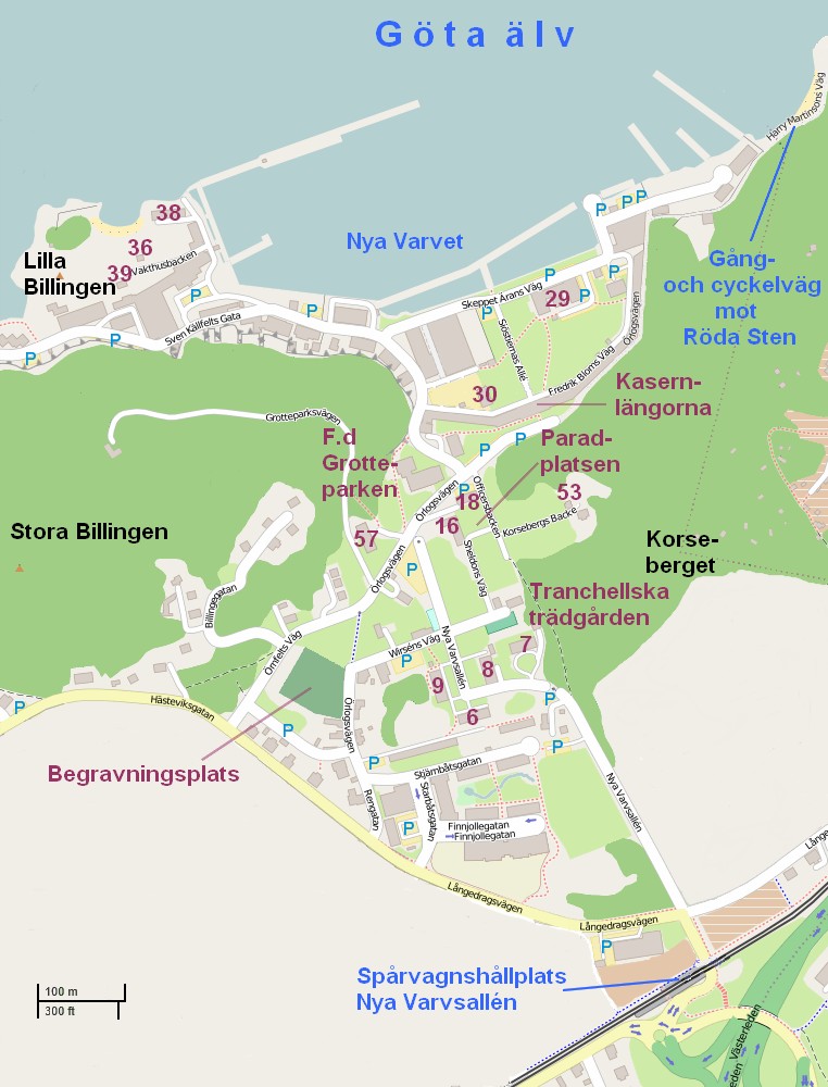
Svenska: Karta över de centrala delarna av Nya Varvet, Göteborg English: Map showing the central part of the former naval shipyard Nya Varvet, Gothenburg, Sweden. |
| Date | |
| Source | Own work |
| Author | Dagjoh |
Licensing[edit]
I, the copyright holder of this work, hereby publish it under the following license:
This file is licensed under the Creative Commons Attribution-Share Alike 4.0 International license.
- You are free:
- to share – to copy, distribute and transmit the work
- to remix – to adapt the work
- Under the following conditions:
- attribution – You must give appropriate credit, provide a link to the license, and indicate if changes were made. You may do so in any reasonable manner, but not in any way that suggests the licensor endorses you or your use.
- share alike – If you remix, transform, or build upon the material, you must distribute your contributions under the same or compatible license as the original.
File history
Click on a date/time to view the file as it appeared at that time.
| Date/Time | Thumbnail | Dimensions | User | Comment | |
|---|---|---|---|---|---|
| current | 15:32, 3 May 2015 | | 762 × 1,000 (154 KB) | Dagjoh (talk | contribs) | Scale added |
| 15:43, 22 April 2015 |  | 762 × 1,000 (153 KB) | Dagjoh (talk | contribs) | Improved text. | |
| 18:26, 20 April 2015 |  | 762 × 1,000 (149 KB) | Dagjoh (talk | contribs) | User created page with UploadWizard |
You cannot overwrite this file.
File usage on Commons
The following 3 pages use this file:
File usage on other wikis
The following other wikis use this file:
- Usage on en.wikipedia.org
- Usage on sv.wikipedia.org