File:OAK Airport Diagram.svg
Ir a la navegación
Ir a la búsqueda

Tamaño de esta previsualización PNG del archivo SVG: 378 × 545 píxeles. Otras resoluciones: 166 × 240 píxeles | 333 × 480 píxeles | 533 × 768 píxeles | 710 × 1024 píxeles | 1420 × 2048 píxeles.
Archivo original (archivo SVG, nominalmente 378 × 545 píxeles, tamaño de archivo: 749 kB)
Leyendas
Leyendas
Añade una explicación corta acerca de lo que representa este archivo
Resumen
[editar]
| Descripción |
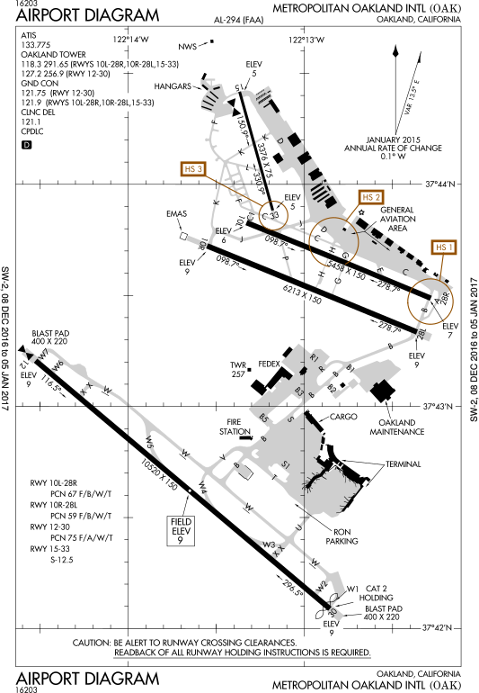
English: FAA Airport Diagram of airport: OAK |
| Fecha | |
| Fuente |
FAA Airport Diagrams; note that these change every 28 days. Taken from PDF on FAA site and converted to SVG using en:Wikipedia:How to draw SVG circuits using Xcircuit. |
| Autor | Produced by the National Aeronautical Charting Office (NACO), a department of the United States en:Federal Aviation Administration. |
| Posición de la cámara | | Ubicación de esta y otras imágenes en: OpenStreetMap |
|---|
W3C-validity not checked.
Licencia
[editar]
This image or file is a work of a Federal Aviation Administration employee, taken or made as part of that person's official duties. As a work of the U.S. federal government, the image is in the public domain in the United States.
|
 |
Historial del archivo
Haz clic sobre una fecha y hora para ver el archivo tal como apareció en ese momento.
| Fecha y hora | Miniatura | Dimensiones | Usuario | Comentario | |
|---|---|---|---|---|---|
| actual | 20:29 10 ene 2017 | | 378 × 545 (749 kB) | Grendelkhan (discusión | contribs.) | SVG version of FAA's PDF diagram. |
No puedes sobrescribir este archivo.
Usos del archivo
Las siguientes páginas usan este archivo:
- User:Chumwa/OgreBot/Potential transport maps/2017 January 1-10
- User:Chumwa/OgreBot/Transport Maps/2017 January 1-10
- User:Chumwa/OgreBot/Travel and communication maps/2017 January 1-10
- Commons:WikiProject Aviation/recent uploads/2017 January 10
- File:OAK2015.pdf
- File:OAK - FAA airport diagram 2015.svg
- Category:San Francisco Bay Oakland International Airport
Uso global del archivo
Las wikis siguientes utilizan este archivo:
- Uso en ur.wikipedia.org
- Uso en www.wikidata.org