File:OS 1896 Cement Mills Halt.png
Jump to navigation
Jump to search

Size of this preview: 622 × 600 pixels. Other resolutions: 249 × 240 pixels | 498 × 480 pixels | 797 × 768 pixels | 1,174 × 1,132 pixels.
Original file (1,174 × 1,132 pixels, file size: 1.65 MB, MIME type: image/png)
Captions
Captions
Add a one-line explanation of what this file represents
Summary
[edit]
| Description |
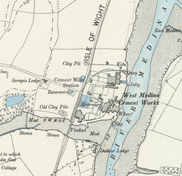
English: Six-inch to the mile map of the area around and including w:Cement Mills Halt railway station; taken from Hampshire & Isle of Wight XC.SW (includes: Cowes; Newport.). |
| Date | |
| Source | https://maps.nls.uk/view/101442237 |
| Author | Ordnance Survey |
This file is in the public domain because OS maps become public domain 50 years after first publication, and include any subsequent reprint of the original, official or otherwise. This includes any republication from the original with adaptions, additions, redrawing, manipulation or incorporation into other images.
|

|
This media file is uncategorized.
Please help improve this media file by adding it to one or more categories, so it may be associated with related media files (how?), and so that it can be more easily found.
Please notify the uploader with {{subst:Please link images|File:OS 1896 Cement Mills Halt.png}} ~~~~ |
File history
Click on a date/time to view the file as it appeared at that time.
| Date/Time | Thumbnail | Dimensions | User | Comment | |
|---|---|---|---|---|---|
| current | 03:20, 6 September 2021 | | 1,174 × 1,132 (1.65 MB) | RandomCanadian (talk | contribs) | Cropped to make details more readable at smaller resolutions |
| 02:52, 6 September 2021 |  | 1,684 × 1,335 (3.07 MB) | RandomCanadian (talk | contribs) | {{subst:Upload marker added by en.wp UW}} {{Information |Description = {{en|Six-inch to the mile map of the area around and including w:Cement Mills Halt railway station; taken from Hampshire & Isle of Wight XC.SW (includes: Cowes; Newport.).}} |Source = https://maps.nls.uk/view/101442237 |Date = 1896 |Author = Ordnance Survey }} {{PD-because|OS maps become public domain 50 years after first publication, and include any subsequent reprint of the original, official or otherwise. This in... |
You cannot overwrite this file.
File usage on Commons
There are no pages that use this file.
File usage on other wikis
The following other wikis use this file:
- Usage on en.wikipedia.org