File:OVGS Network.svg
Jump to navigation
Jump to search

Size of this PNG preview of this SVG file: 605 × 600 pixels. Other resolutions: 242 × 240 pixels | 484 × 480 pixels | 775 × 768 pixels | 1,033 × 1,024 pixels | 2,067 × 2,048 pixels | 778 × 771 pixels.
Original file (SVG file, nominally 778 × 771 pixels, file size: 155 KB)
Captions
Captions
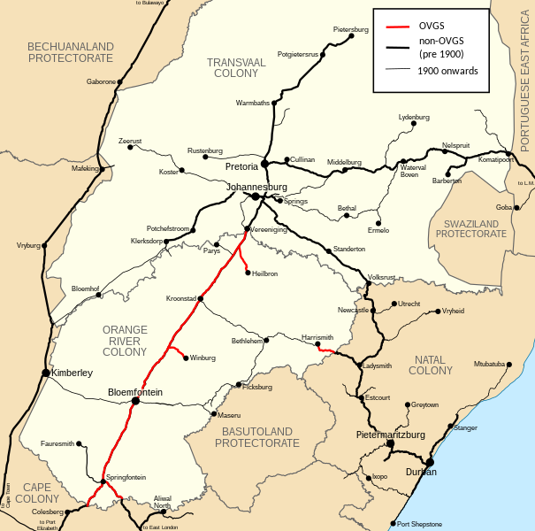
Map of Orange Free State Government Railway network
Summary[edit]
| Description |
English: Map of the Oranje-vrijstaat Gouwermentspoorwegen (Orange Free State Government Railway) network in relation to other railways of the same era.
Afrikaans: Kaart van die Oranje-vrijstaat Gouwermentspoorwegen-netwerk met betrekking tot ander spoorweë van dieselfde era. |
| Date | |
| Source | File:Central_South_African_Railways_map_1910.svg |
| Author | User:Htonl, modified by User:Martinvl |
Licensing[edit]
This file is licensed under the Creative Commons Attribution-Share Alike 3.0 Unported license.
- You are free:
- to share – to copy, distribute and transmit the work
- to remix – to adapt the work
- Under the following conditions:
- attribution – You must give appropriate credit, provide a link to the license, and indicate if changes were made. You may do so in any reasonable manner, but not in any way that suggests the licensor endorses you or your use.
- share alike – If you remix, transform, or build upon the material, you must distribute your contributions under the same or compatible license as the original.
File history
Click on a date/time to view the file as it appeared at that time.
| Date/Time | Thumbnail | Dimensions | User | Comment | |
|---|---|---|---|---|---|
| current | 16:44, 6 June 2020 | | 778 × 771 (155 KB) | Martinvl (talk | contribs) | Missing lines coloured red |
| 20:01, 5 June 2020 |  | 778 × 771 (162 KB) | Martinvl (talk | contribs) | Uploaded a work by User:Htonl, modified by User:Martinvl from https://commons.wikimedia.org/wiki/File:Central_South_African_Railways_map_1910.svg with UploadWizard |
You cannot overwrite this file.
File usage on Commons
The following 2 pages use this file:
File usage on other wikis
The following other wikis use this file:
- Usage on af.wikipedia.org
- Usage on www.wikidata.org