File:Occupation of Poland 1941.png
跳转到导航
跳转到搜索
本预览的尺寸:451 × 600像素。 其他分辨率:180 × 240像素 | 361 × 480像素 | 577 × 768像素 | 770 × 1,024像素 | 2,487 × 3,307像素。
原始文件 (2,487 × 3,307像素,文件大小:967 KB,MIME类型:image/png)
说明
说明
添加一行文字以描述该文件所表现的内容
摘要[编辑]
| 描述 |
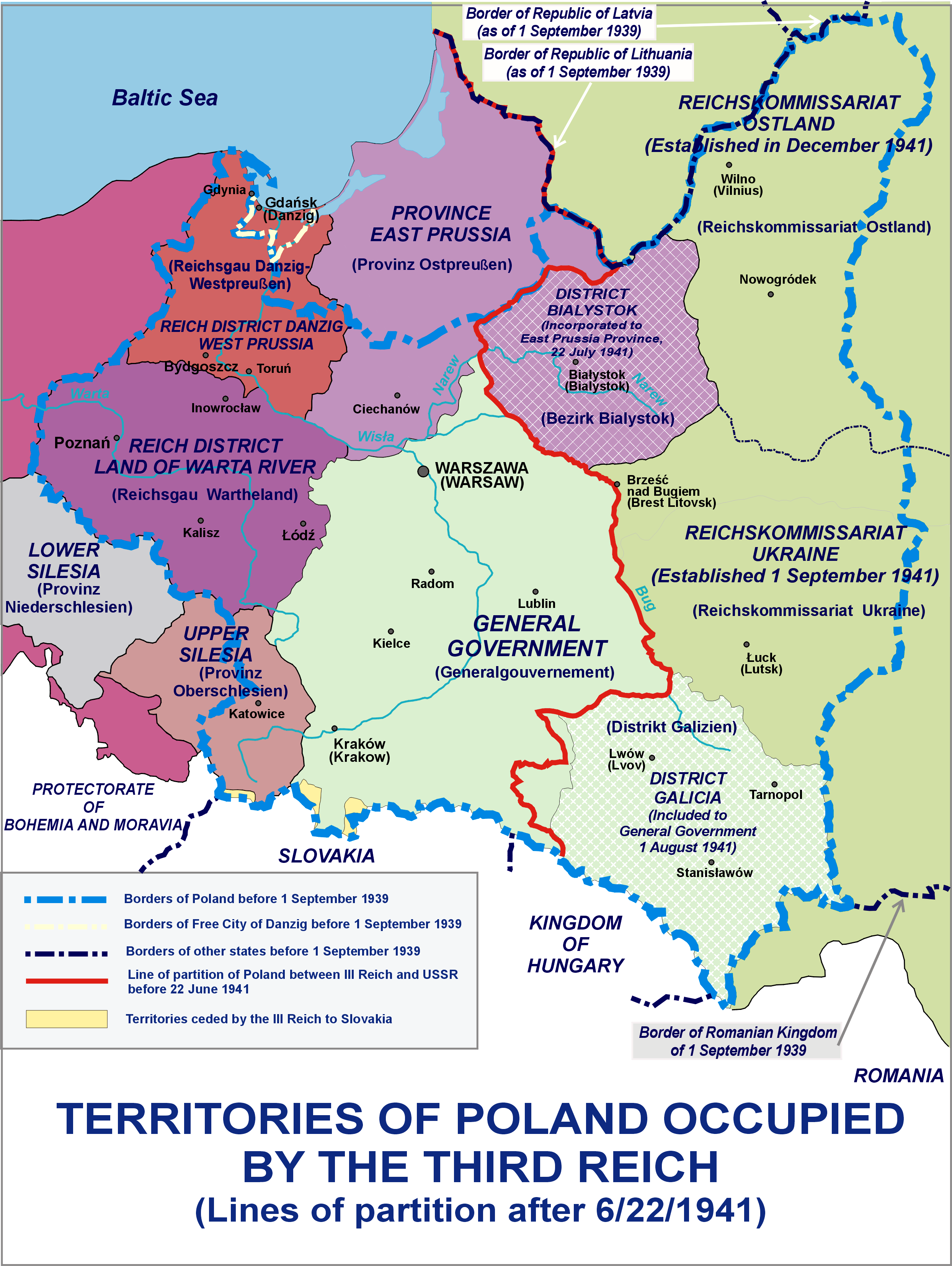
English: Territories of Poland occupied by the Third Reich - Lines of partition after 6/22/1941
Polski: Tereny Polski zajęte przez III Rzeszę - podział po 22.06.1941 |
| 日期 | |
| 来源 | 自己的作品 |
| 作者 | Lonio17 |
| 其他版本 |
[]
|


许可协议[编辑]
我,本作品著作权人,特此采用以下许可协议发表本作品:

|
已授权您依据自由软件基金会发行的无固定段落及封面封底文字(Invariant Sections, Front-Cover Texts, and Back-Cover Texts)的GNU自由文件许可协议1.2版或任意后续版本的条款,复制、传播和/或修改本文件。该协议的副本请见“GNU Free Documentation License”。 |
This file is licensed under the Creative Commons Attribution-Share Alike Attribution-Share Alike 4.0 International, 3.0 Unported, 2.5 Generic, 2.0 Generic and 1.0 Generic license.
- 您可以自由地:
- 共享 – 复制、发行并传播本作品
- 修改 – 改编作品
- 惟须遵守下列条件:
- 署名 – 您必须对作品进行署名,提供授权条款的链接,并说明是否对原始内容进行了更改。您可以用任何合理的方式来署名,但不得以任何方式表明许可人认可您或您的使用。
- 相同方式共享 – 如果您再混合、转换或者基于本作品进行创作,您必须以与原先许可协议相同或相兼容的许可协议分发您贡献的作品。
您可以选择您需要的许可协议。
文件历史
点击某个日期/时间查看对应时刻的文件。
| 日期/时间 | 缩略图 | 大小 | 用户 | 备注 | |
|---|---|---|---|---|---|
| 当前 | 2021年10月8日 (五) 12:15 | | 2,487 × 3,307(967 KB) | Kamilhrub(留言 | 贡献) | Corrected border of Lublin and Galicia districts, which didn't change after 1941 (source: Amtliches Gemeinde- und Dorfverzeichnis für das Generalgouvernement auf Grund der Summarischen Bevölkerungsbestandsaufnahme am 1. März 1943) |
| 2015年7月26日 (日) 19:55 |  | 2,487 × 3,307(959 KB) | Poeticbent(留言 | 贡献) | restored contrast experimentally | |
| 2014年4月5日 (六) 08:06 |  | 2,487 × 3,307(964 KB) | Poeticbent(留言 | 贡献) | same with the burgundy | |
| 2014年4月5日 (六) 07:43 |  | 2,487 × 3,307(964 KB) | Poeticbent(留言 | 贡献) | lighter background on the right, easier to read text | |
| 2014年4月5日 (六) 07:39 |  | 2,487 × 3,307(965 KB) | Poeticbent(留言 | 贡献) | toned down very bright green, no longer USSR, different reality | |
| 2014年4月5日 (六) 01:46 |  | 2,487 × 3,307(835 KB) | Lonio17(留言 | 贡献) | {{Information |Description={{en|1=Territories of Poland occupied by the Third Reich - Lines of partition after 6/22/1941}} {{pl|1=Tereny Polski zajęte przez III Rzeszę - podział po 22.06.1941}} |Source={{own}} |Author=Lonio17 |Date=... |
您不可以覆盖此文件。
文件用途
以下8个页面使用本文件:
- User:Lonio17
- User:Magog the Ogre/Maps of conflicts/2015 July
- User:Magog the Ogre/Maps of conflicts/2021 October
- File:Occupation of Poland 1941-es.svg
- File:Occupation of Poland 1941.png
- File:Polska okupacja 1944.png
- File:Polska okupacja 1944E.PNG(文件重定向)
- Template:Other versions/Occupation of Poland 1941
全域文件用途
以下其他wiki使用此文件:
- ar.wikipedia.org上的用途
- az.wikipedia.org上的用途
- bn.wikipedia.org上的用途
- el.wikipedia.org上的用途
- en.wikipedia.org上的用途
- fa.wikipedia.org上的用途
- fr.wikipedia.org上的用途
- he.wikipedia.org上的用途
- hy.wikipedia.org上的用途
- id.wikipedia.org上的用途
- it.wikipedia.org上的用途
- ms.wikipedia.org上的用途
- pl.wikipedia.org上的用途
- pt.wikipedia.org上的用途
- ru.wikipedia.org上的用途
- si.wikipedia.org上的用途
- sl.wikipedia.org上的用途
- sr.wikipedia.org上的用途
- th.wikipedia.org上的用途
- tr.wikipedia.org上的用途
- zh.wikipedia.org上的用途