File:Occupation of Poland 1941.png
跳至導覽
跳至搜尋
預覽大小:451 × 600 像素。 其他解析度:180 × 240 像素 | 361 × 480 像素 | 577 × 768 像素 | 770 × 1,024 像素 | 2,487 × 3,307 像素。
原始檔案 (2,487 × 3,307 像素,檔案大小:967 KB,MIME 類型:image/png)
說明
說明
添加單行說明來描述出檔案所代表的內容
The German Reich's Occupation Areas Of The Second Polish Republic.
摘要
[編輯]| 描述 |
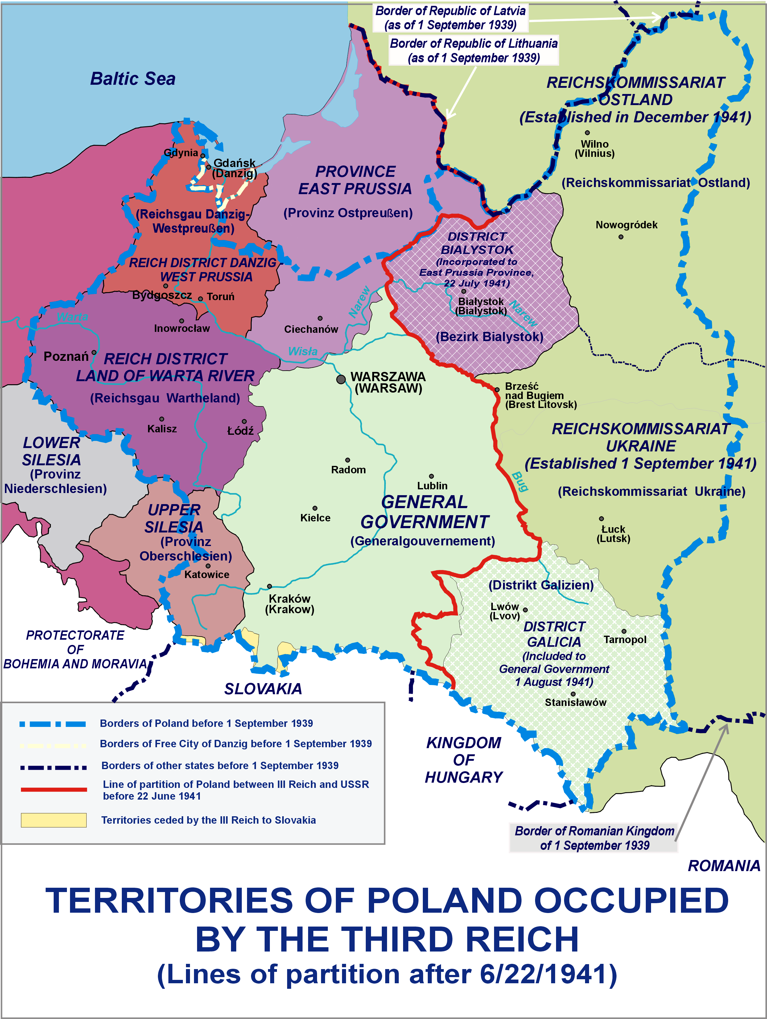
English: Territories of Poland occupied by the Third Reich - Lines of partition after 6/22/1941
Polski: Tereny Polski zajęte przez III Rzeszę - podział po 22.06.1941 |
| 日期 | |
| 來源 | 自己的作品 |
| 作者 | Lonio17 |
| 其他版本 |
[]
|


授權條款
[編輯]
我,本作品的著作權持有者,決定用以下授權條款發佈本作品:

|
已授權您依據自由軟體基金會發行的無固定段落、封面文字和封底文字GNU自由文件授權條款1.2版或任意後續版本,對本檔進行複製、傳播和/或修改。該協議的副本列在GNU自由文件授權條款中。 |
您可以選擇您需要的授權條款。
檔案歷史
點選日期/時間以檢視該時間的檔案版本。
| 日期/時間 | 縮圖 | 尺寸 | 使用者 | 備註 | |
|---|---|---|---|---|---|
| 目前 | 2021年10月8日 (五) 12:15 | | 2,487 × 3,307(967 KB) | Kamilhrub(留言 | 貢獻) | Corrected border of Lublin and Galicia districts, which didn't change after 1941 (source: Amtliches Gemeinde- und Dorfverzeichnis für das Generalgouvernement auf Grund der Summarischen Bevölkerungsbestandsaufnahme am 1. März 1943) |
| 2015年7月26日 (日) 19:55 |  | 2,487 × 3,307(959 KB) | Poeticbent(留言 | 貢獻) | restored contrast experimentally | |
| 2014年4月5日 (六) 08:06 |  | 2,487 × 3,307(964 KB) | Poeticbent(留言 | 貢獻) | same with the burgundy | |
| 2014年4月5日 (六) 07:43 |  | 2,487 × 3,307(964 KB) | Poeticbent(留言 | 貢獻) | lighter background on the right, easier to read text | |
| 2014年4月5日 (六) 07:39 |  | 2,487 × 3,307(965 KB) | Poeticbent(留言 | 貢獻) | toned down very bright green, no longer USSR, different reality | |
| 2014年4月5日 (六) 01:46 |  | 2,487 × 3,307(835 KB) | Lonio17(留言 | 貢獻) | {{Information |Description={{en|1=Territories of Poland occupied by the Third Reich - Lines of partition after 6/22/1941}} {{pl|1=Tereny Polski zajęte przez III Rzeszę - podział po 22.06.1941}} |Source={{own}} |Author=Lonio17 |Date=... |
無法覆蓋此檔案。
檔案用途
下列8個頁面有用到此檔案:
- User:Lonio17
- User:Magog the Ogre/Maps of conflicts/2015 July
- User:Magog the Ogre/Maps of conflicts/2021 October
- File:Occupation of Poland 1941-es.svg
- File:Occupation of Poland 1941.png
- File:Polska okupacja 1944.png
- File:Polska okupacja 1944E.PNG (檔案重新導向)
- Template:Other versions/Occupation of Poland 1941
全域檔案使用狀況
以下其他 wiki 使用了這個檔案:
- ar.wikipedia.org 的使用狀況
- az.wikipedia.org 的使用狀況
- bn.wikipedia.org 的使用狀況
- el.wikipedia.org 的使用狀況
- en.wikipedia.org 的使用狀況
- History of Poland (1939–1945)
- Reichsgau Wartheland
- Territories of Poland annexed by the Soviet Union
- "Polish death camp" controversy
- Belastok Region
- Subdivisions of Polish territories during World War II
- Rape during the Soviet occupation of Poland
- Occupation of Poland (1939–1945)
- User:Falcaorib/Poland-Lithuania
- fa.wikipedia.org 的使用狀況
- fr.wikipedia.org 的使用狀況
- he.wikipedia.org 的使用狀況
- hy.wikipedia.org 的使用狀況
- id.wikipedia.org 的使用狀況
- it.wikipedia.org 的使用狀況
- ms.wikipedia.org 的使用狀況
- pl.wikipedia.org 的使用狀況
- pt.wikipedia.org 的使用狀況
- ru.wikipedia.org 的使用狀況
- si.wikipedia.org 的使用狀況
- sl.wikipedia.org 的使用狀況
- sr.wikipedia.org 的使用狀況
- th.wikipedia.org 的使用狀況
- tr.wikipedia.org 的使用狀況
- zh.wikipedia.org 的使用狀況