File:Official Rea Vaya Route Map.jpg
Jump to navigation
Jump to search

Size of this preview: 800 × 566 pixels. Other resolutions: 320 × 226 pixels | 640 × 453 pixels | 1,024 × 724 pixels | 1,280 × 906 pixels | 2,000 × 1,415 pixels.
Original file (2,000 × 1,415 pixels, file size: 1.02 MB, MIME type: image/jpeg)
Captions
Captions
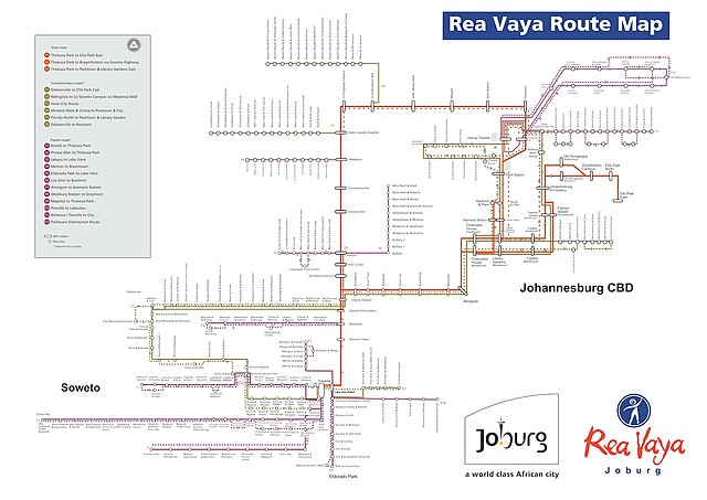
Official map of Rea Vaya routes as of September 2022.
Summary[edit]
| Description |
English: Rea Vaya's official route map as of October 2022. Shows trunk, complimentary, and feeder routes, as well as other information. |
| Date | |
| Source | https://reavaya.org.za/?_=178&&I=1 |
| Author | Official website of REA VAYA |
Licensing[edit]
This image was first published in South Africa and is in the public domain because it is an image of or from:
According to the Copyright Act, 1978 (as amended), § 12 (8) (a), "No copyright shall subsist in official texts of a legislative, administrative or legal nature, or in official translations of such texts; or in speeches of a political nature or in speeches delivered in the course of legal proceedings, or in news of the day that are mere items of press information." |
 |
File history
Click on a date/time to view the file as it appeared at that time.
| Date/Time | Thumbnail | Dimensions | User | Comment | |
|---|---|---|---|---|---|
| current | 20:08, 3 October 2022 | | 2,000 × 1,415 (1.02 MB) | A niche kale geek (talk | contribs) | Uploaded a work by Official website of REA VAYA from https://reavaya.org.za/?_=178&&I=1 with UploadWizard |
You cannot overwrite this file.
File usage on Commons
The following 2 pages use this file:
File usage on other wikis
The following other wikis use this file:
- Usage on en.wikipedia.org